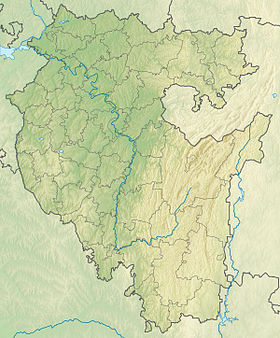
Shakhtau ( Bashk. Shantau - “shah-mountain”, “tsar-mountain” ) is a former shihan located in Ishimbay district , on the border with the Shakhtau microdistrict of the city of Sterlitamak . The name of the mountain is very varied: Shakhtau , Shah - tau , Shah - Tau , Shaketau, Shaketau, Ashak-tau, Tsar-gora.
| Shakhtau | |
|---|---|
| Location | |
| A country |
|
| The subject of the Russian Federation | Bashkortostan |
| Area | Ishimbay district |

One of the chain of four Shihan in the vicinity of the cities of Ishimbay and Sterlitamak along with Tratau , Yuraktau and Kushtau , which are selected on the short list of the project " Seven Wonders of Russia " (like Shihan).
The name Shakhtau is known among the Balkars and Karachais, as they call Elbrus .
Like the rest of the Shihan, the remainder of the Lower Permian (Late Paleozoic ) reef massif, formed over 230 million years ago in the tropical sea ( Ural Ocean ).
Currently, the mountain is completely destroyed as a result of geological work to obtain raw materials by the Bashkir soda company , a quarry is located on the site of the shihan. The fate of Shakhtau can befall several similar sheikhs [1] . In Bashkiria deployed [by whom? ] conservation campaign. Activists consider the act of the destruction of Shakhtau an example of a barbaric attitude towards nature, and the quarry formed in its place is called a scar on the face of Bashkiria .
Content
Physico-geographical characteristics
| External Images | |
|---|---|
| The place where the shihan was | |
| Blasting on the mountain | |
| Shakhtau in the 50s | |
Shakhtau is a short ridge 1.3 km long, 980 m wide, extended in a northwest direction. It rose above the level of the river. Belaya (before the start of development) at 210 m. (336 m above sea level). Located on the right bank of the Seleuk River.
The Shakhtau massif is composed of reefogenic limestones forming the Pinnacle; the eastern slope of the massif is vigorously eroded in pre-Martian time, and accordingly, on the eastern wing there is a sharp dissenting overlapping of the Upper Athenian deposits on the Assel and Sakmara. The formation of the tectono-sedimentary structure of the reef deposits of the Shakhtau massif was also influenced by the regional dislocations of the Urals and, in particular, the formation of the Shikhansky raised horst that poked out and raised the lonely mountains by 1000 m in comparison with the same-aged massifs of the western side of the marginal trough. The combination of the primary whimsical accumulation of sediments of rifogenic facies and superimposed tectonic processes led to the formation of a body that is very complex in its internal structure.
Shakhtau limestones are inherent in the usual qualities of organogenic limestone - chemical purity, light color, massiveness, lack of lamination, texture heterogeneity of different sizes (spotting), a wide variety of rock types, their frequent change. In addition to pure limestones, dolomitic limestones of obviously secondary origin are found in the massif. It should be noted that the Shakhtau limestones are extremely rich in the remains of various organisms of excellent preservation.
Shakhtau is a limestone quarry, officially the “limestone deposit”, for the Sterlitamak soda-cement plant (OJSC “Soda”). Limestone mining began in 1950. By 1975, the peak of the Tsar Mountain was reduced by development by more than 35 m. To date, nothing has remained of the mountain [2] [3] .
At the foot of the mountain is the Shakhtau microdistrict.
History
A detailed study of the mountain began in the 19th century. Wanheim von Kwalen in 1842 published the first information about the Shihan. Somewhat earlier (1841) R. Murchison and E. Verneil visited Shakhtau, who compiled a profile through Shakhtau in the form of a brachianticline fold complicated by a fault. Subsequently, paleontological materials on Shihan were processed by S. Kutorg, V. Miller, H. G. Pander and others, the most complete description of the Shakhtau brachiopods was given by F.N. Chernyshev and N.P. Gerasimov.
By the beginning of the 1930s, there were three points of view on the genesis of shihanas: a) brachiantinal folds, b) erosive remnants, c) reef massifs. The work of a number of geologists carried out in 1936-1939 allowed us to firmly substantiate the reef nature of the Shihan.
The second stage of the study of arrays began after the discovery of oil in the Urals. The similarity of Shakhtau and buried oil and gas bearing masses forced many stratigraphs to turn to it. During the war, geologists of the Bashkir oil expedition of the Academy of Sciences of the USSR repeatedly turned to the Shihan to find out the features of facies and the history of the formation of oil and gas burials in the massifs of the Ishimbay Urals .
Detailed exploration of Shakhtau with mass drilling was started in the 1950s to determine its suitability for a soda-cement plant in Sterlitamak. A large number of wells were drilled, which made it possible to compile a geological map of the massif and a series of profiles through it. At the same time, the complex structure of the massif became clear - its location, the presence of intraformational erosion, in some areas - a cloak-like bedding. It was found that the massif is reefogenic, but wrinkled and was significantly eroded, that is, as if the mutually exclusive assumptions about the genesis of the massif were all partially valid.
In 1959, a burial ground dating from the 13-14th centuries was discovered on the eastern slope.
In the 1960s and 1970s, many geologists visited Shakhtau’s quarries, mainly paleontologists to collect comparative material.
The data on Shakhtau were also used to comprehend the reservoir properties of rifogenic limestones. V.K. Gromov and R.K. Petrova identified two types of cracks, differing in length and degree of openness, which together form four intersecting crack systems.
The microcracking of the rocks was studied by A.M. Tyurikhin, who traced three different-time boundaries of microcracks - the oldest ones resemble stillolites, the middle ones have bitumen or mineral filling, and the youngest ones are open.
Mount Shachtau was the object of a tour of the VIII International Congress on Stratigraphy and Geology of Carboniferous in 1975 .
Notes
- ↑ Steppe natural monuments can be destroyed in Bashkiria / Preservation of the steppes of Russia, 09.16.2011
- ↑ History of Shihan Shakhtau
- ↑ Website of Komsomolskaya Pravda. The Bashkir Soda Company plans to create an open-air museum . KP.RU - Komsomolskaya Pravda website (August 19, 2014). Date of treatment March 23, 2019.
Literature
- Korolyuk I.K.Methods and results of the study of the Permian reefogenic massif of Shakhtau (Bashkir Urals). - M.: Science, 1985.
- Korolyuk I.K., Kirillova I.A., Melamud E.L., Rauser-Chernousova D.M.Nizhnepermsky bioherm massif Shakhtau (Bashkiria). - Bulletin MOIP. Sep. Geology., 1970.
- Report on the additional exploration of limestone from the Shah-Tau deposit in the Ishimbay district of the Republic of Bashkortostan. Report on the work for 1994-2002 with reserves calculation as of 01.01.02. Report. No. ГР 5-93-14 / 7. 38 text. adj., 15 count. adj. -Execute. Khaliullina, F.G .; Kamyshnikov, A.N .; Isaev, V.A. / Bashkirgeologiya OAO. Central Integrated Geological and Geophysical Party (TsKGGP). 2002. −73 s, -Bibliogr.: 14 titles. (Rosgeolfond, Bash. RSF, Soda OJSC, Bashkirgeology OJSC)
Links
- Shakhtau in Bashkortostan. Brief Encyclopedia (inaccessible link) . Archived July 18, 2013.
- Omut memory , blog schopine 22nd-Jun-2013