The Verkhovsky Islands are small islands in the western part of the Peter the Great Bay of the Sea of Japan , formed by two groups of pointed red-colored granite bare rocks, located respectively 4.4 and 5.5 km north-east of Reineke Island . The height of the largest of the islands is 27.3 m [1] . From long distances, Verkhovsky Island has the appearance of two groups of kekurs . Sometimes, the group of kekurs that are closest to Reynek is called Small Verkhovsky, the distant is Bolshoi Verkhovsky, since in fact it is one island with surface drying stones adjoining it. Administratively included in the city of Vladivostok [2] and belong to the Far Eastern Marine Reserve . The surface of the Big Island is covered with grassy vegetation. On the largest kekur of a small group of rocks, vegetation is found only in places, on bare granite rocks, succulent forms are common, taking moisture from sea mists, drizzle and accumulating it in fleshy leaves. Nests of gulls. Verkhovsky Islands are one of the farthest from the nearest land (sea) islands in Primorye. [3] As a result, the water off the coast is very clear. Surrounded by more than forty-meter depths, they are one of the most popular diving areas.
| Verkhovsky | |
|---|---|
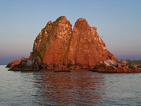 Small group of Kekurs. Peak of Voevodsky. | |
| Specifications | |
| Square | 0.0206 km² |
| Highest point | 27.3 m |
| Population | 0 people (2008) |
| Location | |
| A country |
|
| The subject of the Russian Federation | Primorsky Krai |


History
Verkhovsky Islands were first discovered by French and English sailors in the early 1850s . In 1862 - 1863, they were examined by the expedition of Lieutenant Colonel Vasily Babkin . At the same time, they were named after the crew member of the corvette Kalevala, Lieutenant Vladimir Pavlovich Verkhovsky. The expedition of the lieutenant colonel of the corps of the naval navigators Alexei Semenovich Stenin in 1886 was removed for the second time.
In Soviet times, the islands were part of the border zone and access to them was limited. In 1978, they became part of the Far Eastern Marine Reserve. In the early 1990s, they were opened to tourists. An automatic lighthouse was built in the southern part of the Big Island. In the late 90s, a memorial plaque was installed on one of the rocks in memory of the dead scuba diver [4] .
Notes
- ↑ Navigational description of Peter the Great Bay . Date of treatment May 9, 2005. Archived on May 9, 2005.
- ↑ General Plan of the Vladivostok City District (Unavailable link) . Date of treatment February 21, 2007. Archived February 21, 2007.
- ↑ On the most sea islands, or kekurnaya robinsonade | Hermit's Blog | The nature of the Primorsky Territory . The appeal date is March 13, 2013. Archived March 16, 2013.
- ↑ Khasan region: History, geography, nature