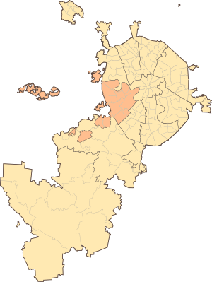
The Western Administrative District ( CJSC ) is one of the 12 administrative districts of the city of Moscow , located in the western part of the city. The company includes 13 districts . The OKATO code is 45.268 billion .
| Western Administrative District | |||||
|---|---|---|---|---|---|
| |||||
| Status | administrative District | ||||
| Included in | Moscow city | ||||
| Includes | 13 districts | ||||
| Date of formation | July 10, 1991 [1] | ||||
| Prefect | Alexey Olegovich Alexandrov [2] | ||||
| Square | 153.0343 [3] km² (14.2%, 4th place) | ||||
| Population ( 2019 ) | ↗ 1 392 993 [4] people (11.04%, 6th place) | ||||
| Density | 9102.49 people / km² (9th place) | ||||
| Metro lines | | ||||
 | |||||
| OKATO Code | |||||
| Official site | |||||


Filyovskaya , Arbatsko-Pokrovskaya , Sokolnicheskaya , Koltsevaya and Solntsevskaya metro lines and the Moscow central ring pass through the territory of the company.
The district is considered one of the most prestigious for living [5] and one of the most environmentally friendly [6] districts of Moscow. In many districts of the district, in particular on Vernadsky Prospekt, numerous institutes and a university were built during the Soviet era, which is why nearby houses served as the place of residence for their employees: university professors, scientists, students. There are many foreign embassies in the Ramenki area.
History
Ancient County History
In the second millennium BC, the lands of the modern Western district were occupied by the tribes of Fatyanovo culture [7] . Their main occupation was cattle breeding. During excavations in Krylatskoye , Dorogomilovo and on the Vorobyovy Gory , many tools were discovered [7] . According to the preserved burial mounds, it is possible to determine the places of ancient settlements. One of these burial grounds was excavated on the territory of Davydkovo . The settlers of the first settlements belonged to the Finno-Ugric group . Settlements were located [7] :
- near the mouth of the Setun river
- in the territory of Filyovsky park
From the 9th-11th centuries, Slavs appeared on this territory. Groups of mounds in Fili , Matveevsky , Ochakov , Krylatsky , Ramenki and Troparyov indicate the settlement of this territory by the Vyatichi tribes [7] . Vyatichi villages were located next to the mounds.
At the end of the XIII century , an independent Moscow principality was formed, and then the villages of Aminyevo , Volynskoye , Troparyovo , which were the fiefdoms of boyar clans, appeared. Then there are princely (and then tsarist) estates in Vorobyov and Krylatsky. The village of Troitskoye-Golenishchevo from the 16th century was the possession of the metropolitans, and later of the patriarchs of “All Russia”. The lands of the present Western district were almost completely part of the Setunsky camp of the Moscow district [7] .
The incorporation of the territory of the okrug into Moscow
Part of the territory of the Dorogomilovo district (to the Kamer-Kollezhsky shaft) was part of Moscow already by the 18th century. By the middle of the 20th century, Moscow was joined by Fili and Potylikh .
In 1960, the borders of Moscow were expanded to the Moscow Ring Road , then the city included Kuntsevo , villages and villages of Davydkovo , Mazilovo , Krylatskoye , Tatarovo , Aminevo , Volynskoye , Matveevskoye , Ochakovo , Troparevo , Nikulino and others.
The territory of the modern Solntsevo , Novo-Peredelkino and Vnukovo districts was included in Moscow only in 1984 (this is the city of Solntsevo , the village of Vnukovo Airport, the village and village of Tolstopaltsevo , the villages of Lukino, Lazenki, Chobota, Fedosino, Orlovo and other)
Creating a County
The Western Administrative District, like other administrative districts of Moscow, was established on July 10, 1991 [1] . The provisional boundaries of the district were determined on August 2, 1991 [8] .
Initially, 17 municipal districts were created as part of the Western Administrative District [9] . In 1993, the municipal districts Troparevo and Nikulino were combined, in 1994 - Kutuzovsky and Dorogomilovsky . In 1995, municipal districts were transformed into districts . In 1997, the districts Ochakovo and Matveevskoye , as well as Ramenki and Mosfilmovsky district were merged. Now in the Western administrative district 13 districts.
It is interesting to note that the Western District is the only Moscow district within the Moscow Ring Road, within which a tram does not run.
Expansion in 2012
As part of the expansion of Moscow, on July 1, 2012, three territories outside the Moscow Ring Road with a total area of about 41 sq km were transferred from the Moscow Region to the ZAO:
| Name the territory | Municipal district |
|---|---|
| separate site " Rublevo-Arkhangelskoye " | Kuntsevo municipal district |
| separate site “ Konezavod, VTB ” | |
| separate Skolkovo site | Mozhaisky municipal district |
These three territories added two exclaves to Moscow , one prominence, and another prominence was expanded .
Population
| Population | ||||||
|---|---|---|---|---|---|---|
| 2002 [10] | 2009 [11] | 2010 [12] | 2012 [13] | 2013 [14] | 2014 [15] | 2015 [16] |
| 1,029,004 | ↗ 1,090,842 | ↗ 1,285,914 | ↗ 1,298,324 | ↗ 1 316 914 | ↗ 1 333 813 | ↗ 1,344,044 |
| 2016 [17] | 2017 [18] | 2018 [19] | 2019 [4] | |||
| ↗ 1,362,701 | ↗ 1,368,731 | ↗ 1 382 516 | ↗ 1 392 993 | |||
Prefecture Guide
On November 26, 2010, Aleksandrov Aleksey Olegovich was appointed prefect [2] .
From 2003 to 2010, the prefect of the Western District was Yuri Mikhailovich Alpatov . Since September 29, 2010, after the resignation of Moscow Mayor Yuri Luzhkov, he was temporarily acting prefect, although a formal order was signed by the new mayor Sergei Sobyanin only on November 1 [20] .
Roads
Several highways pass through the territory of the district, leading mainly to the west. Below is a list of the most significant streets of CJSC.
- Vernadsky avenue
- Lobachevsky street / Aminievskoe highway / Rublevskoe highway
- Michurinsky Prospekt / Ozernaya Street / Borovskoye Shosse
- Lomonosovsky Prospekt / Minskaya Street
- University Avenue
- Kosygina street
- Berezhkovskaya embankment / Vorobyovskoe highway / Mosfilmovskaya street
- Bolshaya Dorogomilovskaya street
- Kutuzovsky Prospekt / Mozhayskoye Shosse
- Bolshaya Filyovskaya street
County Districts
| No. | Area Name [21] | Relevant municipality [22] | Area, [23] ha | Population (as of October 14, 2010) [24] , thousand people | Population density (as of October 14, 2010), people / km² | Housing Area (as of January 1, 2010) [25] , thousand m² | Living space per person (as of January 1, 2010), m² / person |
|---|---|---|---|---|---|---|---|
| one | Vnukovo | Vnukovo | 1742 | 23,367 | 1341.4 | 416.6 | 17.8 |
| 2 | Dorogomilovo | Dorogomilovo | 795 | 68,079 | 8563.4 | 1906.2 | 28.0 |
| 3 | Krylatskoe | Krylatskoe | 1204.46 | 82,606 | 6858.3 | 1850.54 | 22.4 |
| four | Kuntsevo | Kuntsevo | 1656.48 | 147,345 | 8895,1 | 2587,42 | 17.6 |
| five | Mozhaysky | Mozhaisk | 1072.6 | 132,678 | 12369.8 | 2655.9 | 20,0 |
| 6 | Novo-Peredelkino | Novo-Peredelkino | 847.82 | 115,536 | 13627.4 | 1895 | 16,4 |
| 7 | Ochakovo-Matveevskoe | Ochakovo-Matveevskoe | 1754.36 | 114,554 | 6529.7 | 2255.14 | 19.7 |
| eight | Vernadsky avenue | Vernadsky avenue | 465.14 | 61,783 | 13282.7 | 1831.03 | 29.6 |
| 9 | Ramenki | Ramenki | 1853.71 | 129,956 | 7010.6 | 3511.2 | 27.0 |
| ten | Solntsevo | Solntsevo | 1129 | 116,149 | 10287.8 | 2058.4 | 17.7 |
| eleven | Troparyovo-Nikulino | Troparyovo-Nikulino | 1126.66 | 118,556 | 10522.8 | 2895,2 | 24.4 |
| 12 | Filevsky Park | Filevsky Park | 962.43 | 80,593 | 8373.9 | 1605.9 | 19.9 |
| 13 | Fili Davydkovo | Fili Davydkovo | 695.71 | 112,135 | 16118.1 | 2388.6 | 21.3 |
- The largest population area of the Western District is Kuntsevo , the smallest is Vnukovo .
- The largest in area is Ramenki , and the smallest is Vernadsky Avenue .
- The highest population density is in the Fili-Davydkovo region , and the lowest is in Vnukovo .
Religion
- Orthodox churches
On the territory of the Western District there are more than 60 Orthodox churches, united in the Mikhailovsky and St. George Deaneries of the Moscow City Diocese of the Russian Orthodox Church . Deanery of the district - Archpriest George Studenov, rector of the Church of the Archangel Michael in Troparyov [26] .
- Temples of other faiths
On the territory of the district, in Victory Park , there is also a memorial mosque and a memorial synagogue .
Notes
- ↑ 1 2 Order of the Mayor of Moscow of July 10, 1991 No. 47-PM “On the Formation of Administrative Districts in Moscow”
- ↑ 1 2 Alexey Alexandrov appointed Prefect of the Western District of Moscow
- ↑ Decree of the Government of Moscow of No. 452-PP “On approval of the balance sheet for the use of land in the city of Moscow for 2009” (06/01/2010). Date of treatment January 2, 2012. Archived January 2, 2012.
- ↑ 1 2 Population of the Russian Federation by municipalities as of January 1, 2019 . Date of treatment July 31, 2019.
- ↑ Moscow splits into rich and poor areas
- ↑ Eco-rating of Moscow districts
- ↑ 1 2 3 4 5 Prime Reality Real Estate Agency // Western Administrative District
- ↑ Order of the Mayor of Moscow dated August 2, 1991 No. 78-PM “On Establishing the Temporary Borders of Moscow Administrative Districts” Archived copy of September 24, 2014 on Wayback Machine ( expired on January 17, 1997 )
- ↑ Order of the Mayor of Moscow dated September 12, 1991 No. 146-PM “On Establishing the Temporary Borders of Moscow Municipal Districts” ( as amended and supplemented on December 16, 1991, March 2, 1992, September 28, 1993, April 1, December 22, 1994 )
- ↑ 2002 All-Russian Population Census. Tom. 1, table 4. The population of Russia, federal districts, constituent entities of the Russian Federation, regions, urban settlements, rural settlements - district centers and rural settlements with a population of 3 thousand or more . Archived February 3, 2012.
- ↑ The number of permanent population of the Russian Federation by cities, urban-type settlements and regions as of January 1, 2009 . Date of treatment January 2, 2014. Archived January 2, 2014.
- ↑ VPN-2010. Appendix 1. Population by districts of the city of Moscow . Date of treatment August 16, 2014. Archived on August 16, 2014.
- ↑ Population of the Russian Federation by municipalities. Table 35. Estimated resident population as of January 1, 2012 . Date of treatment May 31, 2014. Archived May 31, 2014.
- ↑ The population of the Russian Federation by municipalities as of January 1, 2013. - M.: Federal State Statistics Service of Rosstat, 2013. - 528 p. (Table 33. The population of urban districts, municipalities, urban and rural settlements, urban settlements, rural settlements) . Date of treatment November 16, 2013. Archived November 16, 2013.
- ↑ Table 33. The population of the Russian Federation by municipalities as of January 1, 2014 . Date of treatment August 2, 2014. Archived on August 2, 2014.
- ↑ The population of the Russian Federation by municipalities as of January 1, 2015 . Date of treatment August 6, 2015. Archived on August 6, 2015.
- ↑ Population of the Russian Federation by municipalities as of January 1, 2016
- ↑ The population of the Russian Federation by municipalities as of January 1, 2017 (July 31, 2017). Date of treatment July 31, 2017. Archived July 31, 2017.
- ↑ The population of the Russian Federation by municipalities as of January 1, 2018 . Date of treatment July 25, 2018. Archived July 26, 2018.
- ↑ Decree of the Moscow Mayor of November 1, 2010 No. 119-UM “On Alpatov Yu. M.” (inaccessible link)
- ↑ Law No. 13-47 of July 5, 1995 on the Territorial Division of the City of Moscow ( revised December 4, 2002 )
- ↑ The Law of the City of Moscow of October 15, 2003 No. 59 “On the Names and Borders of Intracity Municipalities in the City of Moscow”
- ↑ Territorial body of the Federal State Statistics Service for Moscow // Indicators of municipalities (2010) // Section 6. Territory. Total Land Area of the Municipality Archived November 12, 2010 on Wayback Machine
- ↑ Table 2. Population of regions and urban settlements of the constituent entities of the Russian Federation // Preliminary results of the 2010 All-Russian Population Census : Stat. Sat / Rosstat .. - Moscow: IIC "Statistics of Russia", 2011. - P. 32 - 86 .
- ↑ Territorial body of state statistics in Moscow // Indicators of municipalities (2010) // Section 8. Communal sphere. Total Living Area Archived November 12, 2010 at Wayback Machine
- ↑ The official website of the Mikhail Deanery
Literature
- Versts Moscow. Western Administrative District: Historical and Cultural Heritage / Ed. Advice: Yu. M. Alpatov (previous) and others .-- M .: Grand, 2007 .-- 400 p. - 3000 copies.