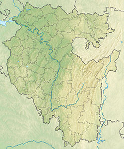
White ( tat. Agyydel , Bashk. Aғiҙel ![]() listen ) - a river in the Southern Urals and in the Urals ; the left and largest tributary of the Kama [2] . It flows through the territory of Bashkortostan and along its border with Tatarstan [3] . The river is 1430 km long, its catchment area is 142,000 km² [4] [5] , the longest river in Bashkortostan.
listen ) - a river in the Southern Urals and in the Urals ; the left and largest tributary of the Kama [2] . It flows through the territory of Bashkortostan and along its border with Tatarstan [3] . The river is 1430 km long, its catchment area is 142,000 km² [4] [5] , the longest river in Bashkortostan.
| White | |
|---|---|
| head off. Aғiҙel , tat. Agyidel | |
 Bridge over Belaya in Ishimbay city Bridge over Belaya in Ishimbay city | |
| Characteristic | |
| Length | 1430 km |
| Pool | 142,000 km² |
| Water consumption | 950 m³ / s (at the mouth) |
| Watercourse | |
| Source | |
| • Location | Mount Iremel |
| • Height | 744 m |
| • Coordinates | |
| Mouth | Nizhnekamsk reservoir |
| • Location | 177 km on the left. the bank of the Kama |
| • Height | 62 m |
| • Coordinates | |
| River slope | 0.48 m / km |
| Location | |
| Water system | Nizhnekamsk reservoir → Kama → Volga → Caspian Sea |
| A country |
|
| Regions | Bashkortostan , Tatarstan |
| HWR code | |
Content
Geography
The source is located in the swamps east of Mount Iremel , the second largest peak in the South Urals, located in the northeast of the Beloretsky district of Bashkortostan. It starts at the foot of the Avalyak ridge at an altitude of 744 meters, near the village of Novokhusainovo, Uchalinsky district . In the upper reaches of the banks of the Belaya are swampy. Below the village of Tyrlyansk, the valley narrows sharply, in some areas its slopes are steep, steep, covered with forest. Below the confluence of the right tributary of the Nugush River, as it reaches the plain, the valley gradually expands; after the confluence of the Ufa River, Belaya is a typically flat river.
Flowing along a vast floodplain teeming with old people , the river forms many bends and breaks into branches. The right bank is usually more elevated than the left.
The food of the river is mainly snowy. The average annual water discharge at Birsk is 858 m³ / s, at the mouth - 950 m³ / s. The river freezes, as a rule, in the second half of November; it opens in mid-April.
About 60% of the annual runoff occurs during the spring flood (an average of 75 days). The average start date for the flood: April 10 , end: July 23 . During floods, the turbidity reaches 900 mg / L (the rest of the time about 50 mg / L).
Tributaries with a length of more than 100 km: Ashkadar, Base, Bir, Fast Tanyp, Dema, Zilim, Karmasan, Kuganak, Nugush, Sim, Xun, Uzyan, Urshak, Ufa, Chermasan.
Flora and Fauna
Flora
Belaya shores are mainly occupied by steppe natural communities , forests (mostly broad-leaved ) are found only in places. In the middle reaches, the riverbanks are mostly covered with poplars , willows , and rose hips . Blackberries grow in large quantities along the banks of the river.
Fauna
Perch , common roach , pike , chub , bleak, catfish , burbot , ruff , bream , silver bream , sterlet , gudgeon , pike perch , trout (in the upper reaches), asp , ide , grayling , taimen (almost gone), dace , czech , podust , bruise , rudd , eye , rotan , crucian carp .
Tributaries
(km from the mouth; river lengths greater than 100 km are indicated)
- 68 km: Kun (ave)
- 77 km: Ashaesh (ave)
- 83 km: Xun (lv) (length 209 km)
- 85 km: Ministe (lv)
- 101 km: Rotten Tanyp (pr)
- 110 km: Base (BG) (length 123 km)
- 115 km: Fast Tanyp (pr) (length 345 km)
- 144 km: Kuvash (lv)
- 178 km: Evbaza (lv)
- 260 km: Tutankin (ave.)
- 262 km: Bir (pr) (length 128 km)
- 292 km: Talbaza (lv)
- 308 km: Ulanda (ave)
- 332 km: Chermasan (lv) (length 186 km)
- 342 km: Kudyshla (lv)
- 387 km: Karmasan (lv)
- 408 km: Semenovka (pr)
- 416 km: Potekha (pr)
- 420 km: Eric (lv)
- 475 km: Dema (lv) (length 535 km)
- 487 km: Ufa (pr) (length 918 km)
- 502 km: Bersianka (lv)
- 504 km: Urshak (lv) (length 193 km)
- 553 km: Karlaman (lv)
- 561 km: Sim (pr) (length 239 km)
- 585 km: Zilim (ave.)
- 635 km: Burles
- 669 km: Usolka (ave.)
- 693 km: Zigan (ave.)
- 700 km: Kuganak (lv) (length 102 km)
- 732 km: Seleuk (pr)
- 743 km: Ashkadar (lv) (length 165 km)
- 771 km: Tayruk (ave.)
- 837 km: Nugush (ave.) (Length 235 km)
- 856 km: Meleuz (lv)
- 868 km: Balsa (lv)
- 883 km: Krivilya (lv)
- 904 km: Menu (BG)
- 922 km: Uzia (inflow of Belaya) Uzia (lv)
- 923 km: Irtyubyak (lv)
- 963 km: Akavaz (lv)
- 991 km: Meleuz (lv)
- 994 km: Batran (lv)
- 1011 km: Kizylyar (pr)
- 1016 km: Vashish (ave.)
- 1026 km: Irgizla (lv)
- 1041 km: Shulgan (ave.)
- 1046 km: Yamashla (ave)
- 1048 km: Tjutjulena (lv)
- 1052 km: Taraval (lv)
- 1060 km: Kurygas (ave.)
- 1065 km: Cana (lv)
- 1067 km: Big Maygashty (ave)
- 1092 km: Alakuyan (ave)
- 1098 km: South Uzyan (lv)
- 1107 km: Bugundy (pr)
- 1129 km: Kurgashly (ave.)
- 1134 km: Kaltiagau (ave.)
- 1135 km: Big Apshak (lv)
- 1158 km: Kardyk (ave.)
- 1159 km: Terga (ave.)
- 1167 km: Ashkarka 2nd (lv)
- 1175 km: Greater Avzyan (pr)
- 1180 km: Ashkarka (ave)
- 1187 km: Irlya (ave)
- 1188 km: Kaga (lv)
- 1212 km: Black (lv)
- 1218 km: Kukhtur (ave.)
- 1238 km: Northern Uzyan (Sukhoi Uzyan) (lv)
- 1256 km: Big Yevluk (pr)
- 1269 km: Greater Sargaya (lv)
- 1271 km: Nayaza (ave.)
- 1274 km: Yandyk (ave.)
- 1277 km: Kadysh (ave.)
- 1281 km: Buganak (ave.)
- 1283 km: Ryaz (lv)
- 1288 km: Arvyak (lv)
- 1300 km: Yatva (lv)
- 1312 km: Ukshuk (lv)
- 1317 km: Nura (ave.)
- 1318 km: Mata (lv)
- 1356 km: Upper Mata (lv)
- 1363 km: Tirlyan (ave.)
- 1367 km: Cherry Dol (lv)
- 1379 km: City Key (lv)
- 1379 km: Lesser Kulbak (lv)
- 1387 km: Black (D)
- 1395 km: Big Avnyar (ave)
- 1396 km: City (lv)
- 1401 km: Itkulkin Klyuch (Ulu-Bainas Stream) (lv)
Economic Use
An important waterway of Bashkortostan . The river is accessible for navigation from Tabinsky (656 km). Regular communication is provided from Ufa . Belaya is an integral part of the Moscow - Ufa waterway, along which tourist trips are organized.
It is planned to build a cascade of three hydroelectric facilities: in 2003 the first Yumaguzinsky reservoir was built, in 2005 the last unit of the Yumaguzinsky hydroelectric station was launched. In recent years, the river has become shallow as a result of the construction of this reservoir.
Water from the river is widely used for watering gardens, and is rarely used as drinking water. Use for industrial production ( Gazprom Neftekhim Salavat , etc.) is limited, enterprises are switching to closed cycles of water use.
In the near future, it is planned to change the channel and deepen the 23-kilometer section of the river from the village of Gruzdevka, Ilishevsky district of Bashkiria, to the village of Azyakul, Aktanyshsky district of Tatarstan. This major infrastructure project has already been funded by 25 million rubles. by order of the acting Head of the Republic of Bashkortostan Radiy Khabirova . The purpose of the work is to get the opportunity to export grain to the river-sea class vessels through this waterway. [6] [7] [8]
Bridges
Numerous bridges are thrown across the river, the largest of which are automobile and railway bridges in Ufa.
Administrative Borders
The Belaya River (including the floodplain estuary) flows through the territory or along the border of the following areas:
- areas of Bashkortostan - Arkhangelsk , Aurgazinsky , Beloretsky , Birsky , Annunciation , Buraevsky , Burzyansky , Gafursky , Dyurtyulinsky , Iglinsky , Ilishevsky , Ishimbaysky , Karmaskalinsky , Krasnokamsky , Kugarchimsky , Ulitsa , Ulyufimazinsky , Kulyufazy , Ulyufazy , Ulyanovsk Agidel district , mountains. Kumertau district , mountains. Salavat district , mountains. District Sterlitamak , mountains. Ufa district ;
- Aktanyshsky district of Tatarstan;
- Karakulinsky district of Udmurtia .
Settlements
Cities on Belaya (from the source): Beloretsk , Meleuz , Salavat , Ishimbay , Sterlitamak , Ufa , Blagoveshchensk , Birsk , Dyurtyuli , Agidel .
History and Etymology
The name Volga , in ancient times Idel (Itil; Bashk. Iel ), did not coincide with modern meaning; it was believed that the Idel River begins at the confluence of the Ak-Idel and Kara-Idel rivers ( Ufa river ) [9] . Consequently, the Agidel River was considered current only until modern Ufa . Idel’s form was preserved in Bashkir folklore and colloquial speech [10] .
In the 16th – 17th centuries, the form of Belaya Volozhka was fixed in Russian historical and geographical literature [11] . In particular, a similar form is recorded in the " Book of the Big Drawing " of 1627 [12] .
The Russian name Belaya is similar to the Bashkir Aғiҙel or Tatar Agyydel - a white river that dates back to the Turkic ak - white and the ancient Turkic idel - water, river. Thus, as it were, the two rivers of this locality are contrasted, Belaya-Agizel - the White River and Ufa - Karaidel ( Bashk. Kariҙel ), which means “black river”, which is possibly due to the color orientation of the cardinal points, the Belaya River flows from the south , and Ufa - from the north [13] [14] .
In Culture
The clouds are white and white
But whiter than these clouds,
Agidel, or in Russian White, -
The river, bright as the girl.
Types of the river are presented in the paintings of the artists A. Тю. Tyulkin “In the homeland of Nesterov”, “Trunilovka”, “Ice drift” and others [15] , B. F. Domashnikov “Morning on the White”, “On the White River”.
The river is sung in the poems of the poets A. Filippov, S. Kulibay and in the song of the DDT group “Agidel (White River)”.
On pre-revolutionary postcards
Attractions
The upper reaches of the Belaya River is a popular water tourism destination.
Since the river is very long, a lot of sights are found along its banks. These are the former ironworks Beloretsk and Kagi , a large number of caves in the upper reaches (including Kapova cave ), the former salt pier of Sterlitamak and the fortress of Tabyn .
Water registry data
According to the state water register of Russia, it belongs to the Kama Basin District , the water sector of the river is Belaya from the source to the Arsky Kamer gauging station , and the river sub-basin is Belaya. The river basin of the river is Kama .
The code of the object in the state water register is 10010200112111100016731 [4] .
Gallery
The middle course of the river. Entrance to the Kapova cave
White in the middle course
White Embankment in Ufa
White in the city of Ishimbay
White in Salavat
The average course of the river
Barges on Belaya near Birsk
Barges on Belaya near Birsk
Notes
- ↑ Surface Water Resources of the USSR: Hydrological Understanding. T. 11. The Middle Urals and the Urals. Vol. 1. Kama / ed. V.V. Nikolaenko. - L .: Gidrometeoizdat, 1966 .-- 324 p.
- ↑ Belyavsky P.E. , Rudakov V.E. Kama, river // Encyclopedic Dictionary of Brockhaus and Efron : 86 volumes (82 volumes and 4 additional). - SPb. , 1890-1907.
- ↑ Belaya (river in the Bashkir Autonomous Soviet Socialist Republic) // Great Soviet Encyclopedia : [in 30 vol.] / Ch. ed. A.M. Prokhorov . - 3rd ed. - M .: Soviet Encyclopedia, 1969-1978.
- ↑ 1 2 State Water Register . White . textual.ru . Ministry of Natural Resources of Russia (March 29, 2009). Date of treatment December 20, 2018. Archived March 29, 2009.
- ↑ N.I. Alekseevsky , M.M. Antonova. White . - An article from the popular science encyclopedia Water of Russia. Date of treatment April 3, 2017.
- ↑ Bashkiria will change Belaya’s channel for grain export to Turkey and Iran . RBC. Circulation date May 18, 2019.
- ↑ Bashkiria plans to supply grain across the Belaya River to Iran, Turkey and the Baltic states . www.bashinform.ru (May 17, 2019). Circulation date May 18, 2019.
- ↑ Bashkiria plans to supply grain to Iran, Turkey and the Baltic states along the Belaya River . Bash.News (May 17, 2019). Circulation date May 18, 2019.
- ↑ Egorov V. M. The historical geography of the Golden Horde in the XIII — XIV centuries.
- ↑ Dictionary of toponyms of the Bashkir Autonomous Soviet Socialist Republic. - Ufa: Bashkir book publishing house, 1980. - 200 p. - S. 18-19.
- ↑ Dictionary of place names of the Republic of Bashkortostan. Ufa: Kitap, 2002 .-- 256 p. - S. 23.
- ↑ Matveev A.K. Geographical names of the Urals: Toponymic Dictionary. - Yekaterinburg: Socrates, 2008 .-- 352 p. - S. 35.
- ↑ Pospelov E. M. Geographical Names of the World: Toponymic Dictionary. - M: AST. 2001
- ↑ Ufa, river // Brockhaus and Efron Encyclopedic Dictionary : in 86 volumes (82 volumes and 4 additional). - SPb. , 1890-1907.
- ↑ Artist Tyulkin Alexander Erastovich - Artist Tyulkin Alexander Erastovich - life and work (inaccessible link) . Archived on November 17, 2016.
Literature
- Article in the Bashkir Encyclopedia
- Sitnikov G. G., Fedenko I. I. Moscow — Ufa: On the reaches of five rivers. - M .: Geografgiz, 1954. - S. 155-169. - 200 p. - 15,000 copies. (in per.)