Kukunor (Tsinkhai) [1] ( Kit. Ex. 湖 , Pall .: Qinghai Hu , Mong. Hөh Nuur ) is the second largest drainage mountain salt lake in Central Asia after Issyk-Kul Lake . Located in Qinghai province in the west of China . The length is about 105 km, the width is up to 65 km, the area is about 4200 km², the greatest known depth is 38 m, it is located at an altitude of 3205 m and occupies the central part of the Kukunorsky plain .
| Lake | |
| Kukunor ( Qinghai ) | |
|---|---|
| Whale. 青海 湖 , Mong. Hөhnuur | |
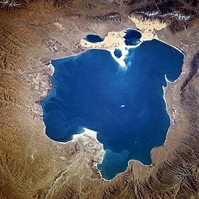 satellite photo (1994) | |
| Morphometry | |
| Absolute height | 3205 m |
| Dimensions | 110 × 80 km |
| Square | 4,200 km² |
| Deepest | 38 m |
| Location | |
| A country |
|
| Region | Qinghai |


The Chinese ( Qinghai , 青海), Mongolian ( Huh-Nur , Hөh Nuur) and Tibetan (Tso Ngonpo) names are the same and mean “blue lake”.
The shores are fragmented weakly; developed ancient lake terraces (up to 50 m). The bottom is composed mostly of silt. Several sandy islands. 23 rivers flow into Kukunor, the most aquifer of which, the Bukh-Gol River , forms the delta , which flows into Kukunor in the west; other rivers - Daotanhe . Summer flood on the rivers causes seasonal fluctuations in the level of the lake. In summer, the water warms up to 18–20 ° C, from November to March the lake freezes. Water salinity during dry periods reaches 11.3 g / l. Fish is found, mainly from the carp family. Of the Europeans, Kukunor was the first to investigate N. M. Przhevalsky in 1872.
Notes
- ↑ Kukunor // Dictionary of geographical names of foreign countries / resp. ed. A.M. Komkov . - 3rd ed., Pererab. and add. - M .: Nedra , 1986. - p. 180.