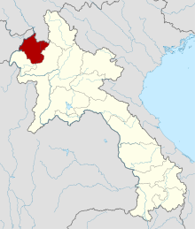
Luangnamtha ( Laos. ຫລວງ ນໍ້າ ທາ ) is a province in the north of Laos .
| Provinces | |
| Luangnamtha | |
|---|---|
| Laos. ຫລວງ ນໍ້າ ທາ | |
| A country | Laos |
| Includes | 5 districts |
| Adm. Centre | Luangnamtha |
| History and Geography | |
| Square | 9325 km² (14th place ) |
| Timezone | UTC + 7:00 |
| Population | |
| Population | 169 532 people ( 2013 ) ( 14th place ) |
| Density | 15.58 people / km² (12th place) |
| Digital identifiers | |
| ISO 3166-2 Code | LA-LM |
| Telephone code | |
 | |

Content
History
From 1966 to 1976, Luangnamtha was merged with Bokeo Province into Huakhong Province.
Geography
The area of the province is 9325 km² [1] . It borders on the Lao provinces of Bokeo (in the south-west) and Udomsai (in the southeast), as well as Myanmar (in the north-west) and China (in the north). The Mekong River forms the northwestern border of the province. The 3 major tributaries of the Mekong, the Tha, Fa, and Long rivers, flow through Luangnamtha from the northeast to the southwest.
Population
According to data for 2013, the population is 169,532 people [2] .
The dynamics of the population of the province by years:
| 1995 | 1996 | 2005 | 2013 |
|---|---|---|---|
| 115,680 | 115,200 | 145,231 | 169 532 |
Economics
The province is one of the largest producers of sugar cane and natural rubber in the country, with extensive plantations of these crops [3] . Brown coal and copper are being mined. The provincial largest mining company is Viengphoukha Coal Mine Co. Ltd , engaged in the extraction of brown coal [4] . An important role is played by agriculture; The main agricultural crops grown in the province: rice , corn , cassava , peanuts , cardamom , ginger , etc.
Administrative Division
Administratively, the province is divided into the following areas:
- Long (3-03)
- Nale (3-05)
- Namtha (3-01)
- Sing (3-02)
- Viengphukha (3-04)
Notes
- ↑ Luangnamtha Province . Lao Tourism Organization. Date of treatment December 1, 2012. Archived on May 13, 2013.
- ↑ Luang Nam Tha (English) . World Gazetteer. Date of treatment May 11, 2013. Archived May 13, 2013.
- ↑ Lao People's Democratic Republic: Second Poverty Reduction Strategy Paper (EPub) . - International Monetary Fund, October 21, 2008. - P. 54. - ISBN 978-1-4527-9182-1 .
- ↑ Geological Survey , p. 14.
Literature
- Geological Survey (US). Minerals Yearbook: Area Reports: International 2008: Asia and the Pacific . - Government Printing Office, October 25, 2010. - P. 14–. - ISBN 978-1-4113-2964-5 .