Malaya Nevka - the sleeve of the Neva Delta, extending from the Bolshaya Nevka at the arrow of Kamenny Island .
| Malaya Nevka | |
|---|---|
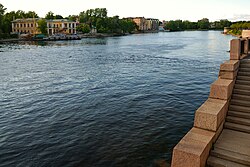 View of Malaya Nevka and Krestovsky Island from the Bolshoi Krestovsky Bridge View of Malaya Nevka and Krestovsky Island from the Bolshoi Krestovsky Bridge | |
| Characteristic | |
| Length | 5 km |
| Water consumption | 224 m³ / s |
| Watercourse | |
| Source | Big Nevka |
| • Coordinates | |
| Mouth | Neva Bay |
| • Height | 0 m |
| • Coordinates | |
| Location | |
| A country |
|
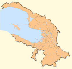
| Region | St. Petersburg |
| HWR code | |
Content
Geographic Information
Separates the Petrograd side from the Kamenny and Krestovsky islands. It flows into the Neva Bay along with Malaya Neva between the Petrovsky and Krestovsky Islands.
Length about 5 km, width 120-300 meters, depth 3.5-7 meters. The average annual flow rate is at the source of 224 m³ / s.
It has tributaries (both left) - Karpovka and Zhdanovka . In the middle part from the Malaya Nevka, the Krestovka River leaves to the right, then flows into the Middle Nevka opposite the Elagin Island .
The left bank in the upper part of the river is arranged and dressed in granite (embankments Pesochnaya and Admiral Lazarev ). The right bank in order to prevent blurring is reinforced with wooden structures.
Malaya Nevka is navigable.
Attractions
- Lopukhinsky garden with a pond
- Kamennoostrovsky Palace
- Seaside Park Victory
- Four bridges are thrown across Malaya Nevka:
- Kamennoostrovsky
- Big Krestovsky
- Lazarevsky
- Big Petrovsky
See also
- Embankment of the Malaya Nevka River
Literature
- City names today and yesterday: Petersburg toponymy / comp. S.V. Alekseeva, A.G. Vladimirovich , A.D. Erofeev et al. - 2nd ed., Revised. and add. - SPb. : Lick , 1997 .-- S. 84. - 288 p. - (Three centuries of Northern Palmyra). - ISBN 5-86038-023-2 .
Links
- Malaya Nevka in the Encyclopedia of St. Petersburg . encspb.ru . Date of treatment January 11, 2019.
- ↑ Surface Water Resources of the USSR: Hydrological Understanding. T. 2. Karelia and the North-West / ed. E.N. Tarakanova. - L .: Gidrometeoizdat, 1965 .-- 700 p.