Kuibyshev Reservoir - a reservoir on the Volga River , the largest in Eurasia and the third largest in the world by area, after Volta and Smallwood [3] [4] . It was formed in 1955 - 1957 after the completion of the construction of the dam of the Volga Hydroelectric Power Station named after V.I. Lenin (now Zhigulevskaya Hydroelectric Power Station ), which blocked the river valley near the city of Stavropol (now Togliatti ). The name is given for the city of Kuibyshev (now Samara ), located downstream. The lower part of the reservoir is often called the Zhiguli Sea [5] .
| Kuibyshev reservoir | |
|---|---|
 Kuibyshev reservoir near Ulyanovsk | |
| Morphometry | |
| Height above sea level | 53 m |
| Dimensions | 500 × up to 40 [1] km |
| Square | 6450 km² |
| Volume | 58 km³ |
| Coastline | 2604 km |
| Deepest | 41 m |
| Average depth | 8 m |
| Specifications | |
| Year of filling | 1957 |
| Pool | |
| Flowing watercourses | Volga , Kama , Sviyaga , Kazanka , Big Cheremshan , Usa |
| Flowing watercourse | Volga |
| Location | |
| A country |
|
| Subjects of the Russian Federation | Samara Region , Chuvashia , Mari El , Tatarstan , Ulyanovsk Region |
| HWR code | |


The length of the reservoir along the Volga is 510 km, the greatest width is 40-44 km at the mouth of the Kama River (another very wide place is 27 km, slightly higher than Ulyanovsk ), the area of the water mirror is 6450 km² (among the rivers it is the second largest in the world; 50, 7% of the area is within the borders of Tatarstan ), the total volume of water is 58 km³, the usable volume is 34 km³. The water level at the dam is 29 m, it spreads along the Volga to the city of Novocheboksarsk , along the Kama - to the mouth of the Vyatka . The reservoir forms large bays along the Kama, Sviyaga , Bolshoi Cheremshan and other rivers valleys.
The main purpose of the reservoir is to generate electricity, improve shipping, water supply, and irrigation. In addition, it is used for fishing.
The reservoir greatly changed the Volga flow regime both above and below the dam: runoff in the flood significantly decreased, and in the low - water period it increased. The water level fluctuations near the city of Kazan are 5-6 m, while before the creation of the reservoir they reached 10-11 m. Compared to the unregulated Volga, the reservoir began to freeze 3-5 days earlier and later free from ice. The microclimate has substantially changed in the zone of 3-6 km near the reservoir, the processes at the bottom and in the coastline have been rebuilt, abrasion and erosion of the coasts have begun, and landslides have intensified. The conditions for the growth of coastal and aquatic vegetation, the habitat of birds and fish, have changed greatly.
Large cities on the banks of the reservoir - Kazan , Tolyatti , Ulyanovsk , Novocheboksarsk , Dimitrovgrad , Zelenodolsk .
Creation History
The first information about projects for the use of water resources of the Middle Volga dates back to the XVIII century [6] . It was proposed to dig a canal to connect the Usa and Volga rivers in its lower reaches, which would reduce the ship route in the Samara Luka area by 6 times [7] .
At the end of the 19th century, efficient hydraulic motors and electric generators appeared , which caused new interest in the possibilities of using water resources [6] . The first project to use the Volga to generate electricity appeared in 1910, when Samara engineer KV Bogoyavlensky began work on a project to build a hydroelectric power station and dam at Samarskaya Luka [8] to ensure the industrial development of the region with cheap energy [9] .
The leadership of the Samara province formed in April 1919 "Commission on the Electrification of the river. Volga in the region of Samara Luke ”led by K. V. Epiphany [10] . The Commission examined the watershed between Usoy and Volga near Perevolok and the Volga floodplain from Stavropol to Samara , in places where it was possible to build hydraulic structures [11] . The results were sent to the Central Electrotechnical Council [12] , however, the Central Electric Networks and the Water Economy Construction Department of the Supreme Economic Council issued a conclusion on the unsuitability of using the energy of lowland rivers, since the construction of dams floods vast floodplain territories [6] .
In 1928, K. V. Bogoyavlensky published a brochure: “Volga regional hydroelectric station. (To the question of Volgostroy). ” The work described in detail the technical and economically calculated project of a complex of two powerful hydroelectric facilities - in the main channel of the Volga and in Perevoloki [13] . In the area of the Zhiguli Gate, it was planned to erect a dam with a length of 2800 m, with a dead spillway of 1280 m in length. The creation of the highest backwater should have been carried out by a system of removable or elevated shields. A hydroelectric power station was built near the dam, on which 8–9 hydraulic units were installed with a working height of turbines of about 11 meters [13] .
Another project of the waterworks was compiled by Professor, Chairman of the Irrigation Commission of the State Planning Commission A. V. Chaplygin [14] [Comm. 1] in 1928. He proposed to build a bottom lintel in the upper part of Samara Luka, which allows to increase the retaining level by 3 meters. Then the hydraulic station at Perevolok will receive a head of 9.5 meters, which will allow to establish its capacity of 210 thousand kW and the average annual output of 1.54 million kW · h [16] . This would make it possible to irrigate 575 thousand ha of agricultural land, and it is noticeably cheaper than using other energy sources [17] .
At the end of the 1920s, an acute shortage of electricity in the Srezhnevolzhsk Territory forced the authorities to intensify efforts to search for sources of cheap energy [18] , and hydropower became one of the main options for obtaining it [19] . In 1929, the Samara commission was transformed into the Volgostroy research bureau [6] . The construction plan of the Samara hydroelectric complex [18] [Comm. 2] . The chief engineer of the bureau was A. V. Chaplygin [20] . The bureau was faced with the task of developing a project for a hydroelectric station near Samarskaya Luka, which, with a pressure of 20 meters, would produce 8–9 billion kWh of energy [21] .
In 1930, the bureau published two new versions of the Zhiguli hydroelectric complex with pressure values at the dam of 15 and 20 meters. According to the results of drilling, which showed the complexity of the hydrogeological conditions in the Zhiguli Gate area and the need for significant additional research [8] , Chaplygin proposed building a dam up the river, on sandy deposits in the Stavropol region [22] .
In June 1931, a permanent meeting on the problem of the Great Volga was organized at the capital sector of the USSR State Planning Commission [23] . As a starting point in the development of a large-scale plan for the reconstruction of the Volga along its entire length, the achievements of Volgostroi were chosen [23] . In the period from 1931 to 1936, many different options for the transformation of the Volga were developed, hundreds of meetings and conferences were held for this purpose. In the general scheme of the Big Volga, the number of waterworks included in it and their parameters were constantly changing [24] . At the same time, the Samara hydroelectric complex [25] was present in all schemes, which was given special attention, because it would be located at the intersection of water and railway lines near significant raw materials and would provide a huge amount of cheap energy - up to 9.2 billion kWh [26] ] .
The designers were forced to abandon the idea of placing a dam gauge near Stavropol; there were neither theoretical nor experimental data in the country for drawing up such a project, not to mention the real experience of building such large hydraulic structures on soft soils [27] . I had to look for places where the dam would lie on a solid foundation. Plots were studied at the Prayer Gully, at Tsarevshchina and Krasnaya Glinka , the scheme of the proposed waterworks and its parameters continued to change [28] . Gradually, the research concentrated around the Zhiguli Gate - the place where the Volga cut through the Zhiguli Mountains massif, separating them from the Falcon Mountains , in the narrowest place between the Serna Mountains on the right bank and Tip-Tyav on the left [20] .
In 1936, an expert commission of the USSR State Planning Commission approved the scheme of the "Big Volga", according to which the main emphasis was placed on large hydroelectric facilities, with a maximum retaining level, which ensured maximum energy production and shipping depths, although large areas were flooded and significant damage was caused to fish au pair [29] . The schematic design of the Big Volga bureau, drawn up in the same year, provided for the location of a hydroelectric station in the Tsarevo-Kurgan alignment, where there were rocky foundations for concrete structures. Concrete and earthen dams were to be located on the Volga, providing a pressure of 31 meters, a hydroelectric power station and shipping locks. Concrete structures were located on limestone, earthen dam - on the sands [30] . It was assumed that the created reservoir will provide a ship passage 3–3.5 meters deep both up and down the Volga [31] .
On August 10, 1937, a joint Decree of the Council of People 's Commissars of the USSR and the Central Committee of the All-Union Communist Party of Bolsheviks (Bolsheviks) No. 1339 "On the construction of the Kuybyshev hydroelectric complex on the Volga River and hydroelectric facilities on the Kama River" [32] was published. The construction department of the Kuibyshev hydroelectric complex (NKSU) was created [33] , the development of the hydroelectric project was also entrusted to NKSU, it was assumed that the technical project would be submitted to the SNK by May 1, 1939 [34] . However, in practice, the design assignment for a long time was significantly changed and adjusted. One of the options became widely known when at the XVIII Congress of the CPSU (b) Ignatov , the first secretary of the Kuybyshev Regional Committee of the CPSU (b), spoke on the future waterworks in more detail. According to him, the level of the Volga in the upper pool was supposed to rise by 32 meters, creating a reservoir with an area of 7.5 thousand km². After filling the reservoir, it was supposed to provide irrigation in an area of 3 million hectares in order to receive from it an increased yield of 35 centners of grain per hectare [35] . However, constant changes in the project led to the fact that the design assignment was approved only in the middle of the summer of 1939 [36] .
The estimated volume of the reservoir increased from 30 [37] to 53 billion m³ with a mirror area of 6.4 thousand m². The renewed design of the hydroelectric complex assumed annual production of 15 billion kWh of electricity, the creation of a deepwater route up the Volga 600 km to Cheboksary, as well as along the Kama up 200 km from the mouth, improving the fairway below the dam with guaranteed depths of 3 meters, irrigation of sown areas in the Volga region with a volume of 2.3 million hectares [38] .
On October 11, 1940, the NKVD issued an order to suspend the construction of the Kuibyshev hydroelectric complex [39] . Among the reasons for this decision, experts indicate the high cost of cementation work on the installation of an airtight curtain in alluvial deposits in the Volga channel and fractured limestones and base dolomites under construction of the hydroelectric complex, and oil production wells on Samara Luka that were not considered in the project and are subject to flooding [40] , and long-term project excessive in the context of the ongoing world war.
Zhiguli returned to plans for the construction of a hydroelectric power station shortly after the end of World War II. In 1949, the design and survey work carried out by the Hydroproject Institute resumed. The left bank floodplain and the channel of the Volga – Veal Volozhka arm, where dense clay deposits were able to withstand significant loads, were recognized as the best option for locating the waterworks [41] .
August 21, 1951 issued a decree of the Government of the USSR "On the construction of the Kuibyshev hydroelectric power station on the Volga River", which gave an official start to the construction [41] .
The Kuibyshev hydroelectric power station under construction at that time was the largest in the world, as well as the created reservoir. With a water level of 28 meters at a dam on the plain Volga, a significant flooding zone arose, capturing the entire Volga-Kama floodplain. Extensive work was carried out to prepare the bed of the future reservoir, including the resettlement of many settlements, their engineering protection, the reorganization of railways and roads, lumbering and forest cleaning, etc. [42] .
The main construction and installation work unfolded in 1953-1955 [42] . In the summer of 1955, work began on blocking the river, which ended on October 31 with the Volga blocking, filling of the reservoir began. On December 29, 1955, the water level in the artificial sea allowed the launch of the first hydroelectric unit of the Kuybyshev hydroelectric station. In May 1957, the reservoir level reached its design level. On October 14, 1957, the last, twentieth hydraulic unit was launched, and on August 10, 1958, a government commission approved the act of accepting the Kuibyshev hydroelectric station for continuous operation [43] .
Physico-geographical characteristics
The Kuybyshev reservoir is located in the central part of the Middle Volga region at the boundary of the forest-steppe province of the Volga Upland and the Low Volga. It is elongated in the meridian direction, in the northwest it is interfaced with the Cheboksary reservoir, in the northeast - with Nizhnekamsk, in the south - with Saratov. Most of the reservoir area is in Tatarstan (50.7%), in the Ulyanovsk region account for 30.9%, and Samara - 14%, the rest falls on the republics of Mari-El and Chuvashia. In the coastal zone there are 26 municipal districts, 55 cities and urban-type settlements, and more than 1900 rural settlements [44] .
The Kuybyshev reservoir carries out seasonal, weekly and daily regulation of the Volga runoff, being the main regulator of the seasonal runoff for the Middle and Lower Volga [45] .
The reservoir is widely used in the national economy, for the needs of the energy sector (actually Zhigulevsk hydroelectric power station), river transport, agricultural irrigation, fish farming, municipal and industrial water supply, recreational and tourist purposes, as well as a wastewater receiver [45] .
Fish Resources
As a result of numerous ichthyological studies of the Middle Volga, the following was revealed. Earlier, 49 fish species lived in the Volga in the area of the Kuibyshev Reservoir [46] . After the construction of the Kuibyshev hydroelectric station due to the loss of passing species, their total number decreased to 39-40. And although some of them are still sporadically found, they no longer have either commercial or environmental impact. Subsequently, smelt and vendace migrated from the north to the reservoir, from the south - tyulka , round goby , star-shaped button head and needle-fish . Numerous attempts have been made to artificially populate the Baunt whitefish , peled , grass carp and silver carp . As a result, the number of species increased slightly [47] [48] : now in the reservoir itself there are 42 species and at least 9 species are preserved only in tributaries [49] . However, it is worth noting that valuable species fell from the fauna from migratory sturgeons , herring and salmon , while from invaders only tyulka and Amur species, which support due to artificial reproduction, have some commercial value.
In general, now scientists are divided into 6 faunal complexes:
- boreal plain ( pike , roach , dace , ide , chub , tench , gudgeon , gold and silver crucian carp , perch , ruff , plucking );
- amphiboreal freshwater ( common carp , pike perch , bersh , sterlet , loach , catfish );
- Pontic freshwater ( bream , bluefin , white-eye , bleak , silver bream , rudd , sabrefish , podust , asp );
- Arctic freshwater ( smelt , vendace , peled , burbot );
- Pontic marine ( tyulka , star head , round goby , needle-fish );
- Chinese plain ( grass carp , white and spotted silver carp, rotan head ).
In general, the process of stabilization of the reservoir’s fish system took place in several stages from the time of filling, and the ecosystem stabilized only by the beginning of the 1980s, when there was a distinct tendency to improve the quality of the reservoir’s waters. However, since the mid-1980s, anthropogenic pressure has been increasing on the reservoir, pollutants are accumulating, the content of biogens and organics is increasing, and the acidity of the water is shifting towards an increase in pH. The content of pesticides and heavy metals is growing, phytoplankton is growing while zooplankton is decreasing, which leads to active blooming of water .
There are so many heavy metals that they begin to show up in fish. Thus, in the main commercial fish of the reservoir already in the late 1980s an excess of zinc (up to 2 MAC), lead (up to 2.6 MAC), chromium (up to 2 MAC) was recorded. In areas of increased technogenic impact in bream, up to 9 MACs of lead and 6 MACs of chromium were noted [50] . The accumulation of pesticides and salts of heavy metals has led to an increase in the incidence of fish, a deterioration in their growth and other biological indicators. Apparently, some pathologies reached the genome level, which led to a decrease in the level of reproduction and a deterioration in the qualitative composition of populations [51] . Of the positive trends, an increase in the reproductive ability and growth indicators of bream in the upper reaches of the reservoir was noted, although they are lower than the river period.
The total impact of all types of pollution of the reservoir, their cumulative and synergistic effects on fish is still very difficult to assess. One of the main indicators of homeostasis is morphological aberration, which can often be the result of hereditary diseases caused by the chronic effect of pollutants on the gene pool of the fish population. Studies of larvae of cyprinids from the reservoir revealed numerous morphological abnormalities in them. In 1996, in 49.4% of fish larvae, abnormalities were observed in 49.4% of fish larvae in the area of relatively clean water discharge in the Avtozavodsky district of Tolyatti . It is not yet possible to determine how much mutagenicity has increased, however, there is evidence that in 1937 the occurrence of morphological deformities in fish larvae of the Volga-Akhtuba floodplain did not exceed 6% [52] .
On the whole, ichthyologists conclude that the appearance of the reservoir had only one positive side for fish resources: winter troubles disappeared, which in river conditions caused severe damage to sturgeons [53] (although sturgeons also almost disappeared).
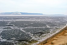
Shoal of the Kuibyshev Reservoir in May 2019
In April-May 2019, in the Kuibyshev reservoir there was a decrease in the water level to the level of 49.86 m above sea level (in this case, according to the rules, the minimum water level in the reservoir at the dam of the waterworks during the flood should not be lower than the level of 49.0 m). In Tatarstan, the river went 3 km from the coast; in Tolyatti, the water went 500 meters. A critical situation has developed on Kazanka and Sviyaga . According to Rosvodresursy , according to the instructions of which the reservoir was discharged, this was due to the low inflow of water to the Volga; as a result, the annual increased water flow for irrigation of the Volga-Akhtuba floodplain stipulated by the rules was made from the water reserves of the Kuibyshev reservoir. prosecutors also pointed to uncontrolled mining of sand. Since May 12, 2019, the reservoir began to fill up; as of June 20, 2019, the reservoir level was at the level of 52.55 m, which is 0.45 m below the normal retaining level [54] [55] [56] [57] [ 58] .
The Volga Basin Institute of Ecology, Russian Academy of Sciences, named a possible error in the calculations as the cause of the shallowing. Because of what the fish had nowhere to spawn , other microorganisms that lived in the water and supported the ecosystem (plankton, benthos) died. The institute also named the causes of environmental pollution of the Kuibyshev reservoir . Basically, river pollution comes from diffuse (uncontrolled) effluents. These are all kinds of flushing from the fields, after a rain of chemicals and fertilizers, motorists who wash their cars in the river, small landfills along the coast near villages and cottages, garbage and toxic substances from which fall into the water. Cesspools of toilets whose contents seep to groundwater. The main reason for the flowering of the reservoir is the propagation of blue-green algae in it due to the discharge of not completely cleaned effluents into the Volga, mainly a huge share of the production of soap powders with phosphorus . [59]
Tributaries
- 1474 km: untitled, near the town of Zhigulevsk (pr)
- 1489 km: Usa (ave.)
- Usinsky Bay
- 45 km: Muranka
- 49 km: Tisherek
- Taydakovo (pr)
- 1502 km: Maza (ave)
- 1536 km: Beketovsky (pr)
- 1541 km: Elaurka (ave)
- 1551 km: Big Cheremshan (lv)
- Cheremshan Bay
- 25 km: Birla
- 31 km: Yerikla
- 38 km: Sosnovka
- 49 km: Yerikla
- 52 km: Melekess
- 1569 km: Sengileika (ave.)
- 1570 km: Stew (ave)
- 1585 km: Kalmayur (lv)
- Arbuga (pr)
- 1593 km: Atza (ave)
- 1657 km: Uren (lv)
- 1669 km: Maina (lv)
- 16 км: Майнский залив: Красная
- 1685 км: Утка (лв)
- 1732 км: Мордовская (пр)
- 1735 км: Ишимовская (пр)
- 1741 км: Бездна (лв)
- 1744 км: Карамалка (пр)
- 1787 км: Мордовка (пр)
- 1804 км: Кама (лв)
- Камский залив
- 8,6 км: Актай (лв)
- 11 км: Мёша (пр)
- 17 км: Мёшинский залив: без названия, у с. Нармонка (пр)
- 24 км: Брысса (пр)
- 32 км: Шуранка (пр)
- 45 км: Курлянка (лв)
- 52 км: Ошняк (пр)
- 55 км: Бетька (пр)
- 59 км: Урайка (пр)
- 67 км: Шентала (лв)
- 68 км: Большая Бахта (лв)
- 74 км: Суша (пр)
- 90 км: Шумбут (пр)
- 106 км: Берсут (пр)
- 120,7 км: Шешма (лв)
- 120,9 км: Заборная (пр)
- 131 км: Омарка (пр)
- 135 км: Пакшинка (лв)
- 146,5 км: Вязовка (пр)
- 146,8 км: Уратьма (лв)
- 1826 км: Казанка (лв)
- 1851 км: Свияга (пр)
- Свияжский залив
- Секерка (лв)
- Сулица (пр)
- Сумка (лв)
- 1875 км: Илеть (лв)
- 1881 км: Аниш (пр)
- 1920 км: Малая Кокшага (лв)
- 1921 км: Большая Кокшага (лв)
Comments
- ↑ Александр Владимирович Чаплыгин (1883—1954) — гидроэнергетик, профессор. В 1930—1936 годах — начальник управления и главный инженер проекта Куйбышевского узла в Гидроэнергопроекте. Позднее работал в Госплане СССР, участвовал в разработке материалов по строительству Куйбышевской ГЭС. Принимал участие в работе комиссии СОПС по научной разработке проблем водного комплекса [15]
- ↑ Позднее название перейдёт управлению НКВД , занимавшемуся строительством Рыбинского и Угличского гидроузлов в верховьях Волги. См. Волгострой .
Notes
- ↑ Александр Васильевич Плащев, В. А. Чекмарев. Гидрография СССР (рус.) . — Гидрометеорологическое изд-во, 1967. — С. 124.
- ↑ Surface Water Resources of the USSR: Hydrological Understanding. T. 12. Lower Volga and Western Kazakhstan. Vol. 1. Lower Volga / ed. O. M. Zubchenko. - L .: Gidrometeoizdat, 1966 .-- 287 p.
- ↑ Михайлов В.Н., Михайлова М.В. Водохранилище . Научно-популярная энциклопедия «Вода России» . Date of treatment April 8, 2019.
- ↑ Водохранилище // Вешин — Газли. — М. : Советская энциклопедия, 1971. — ( Большая советская энциклопедия : [в 30 т.] / гл. ред. А. М. Прохоров ; 1969—1978, т. 5).
- ↑ Шевцов Р., Куклис М. Природа России. Иллюстрированный путеводитель. — Издательство Э, 2016. — С. 38. — 96 с. — (Занимательная энциклопедия). - 4000 copies. — ISBN 9785699907540 .
- ↑ 1 2 3 4 Бурдин Е. А. «Гидростроительство в России…», 2010 .
- ↑ Штеренлихт Д. В. Очерки истории гидравлики, водных и строительных искусств. В пяти книгах. Книга 3. Россия. Конец XVII – начало XIX вв. Учебное пособие для вузов. — М. : ГЕОС, 1999. — С. 253. — 382 с.
- ↑ 1 2 Бурдин Е. А. «Исторические аспекты…», 2010 , с. 108.
- ↑ Богоявленский, 1928 , с. 22 [Цит. по Бурдин Е. А. «Исторические аспекты…», 2010 , с. 108]
- ↑ Комзин, 1960 , с. 14.
- ↑ История создания Куйбышевского водохранилища, 2012 , с. 222.
- ↑ Комзин, 1960 , с. sixteen.
- ↑ 1 2 Вечный двигатель, 2007 , с. 29.
- ↑ Царёв А. П., Царёва М. А. Орошаемое земледелие в Саратовской области (история, взлёт и падение). — Саратов : Новый ветер, 2010. — С. 22. — 258 с. — 50 экз. — ISBN 978-5-98116-123-0 .
- ↑ Чаплыгин Александр Владимирович . Альманах «Россия. XX век» . Архив Александра Н. Яковлева. Дата обращения 22 февраля 2016. Архивировано 16 марта 2016 года.
- ↑ Чаплыгин А. В. Проблема ирригации Заволжья // Плановое хозяйство : журнал. — М. : Издательство Госплана СССР, 1928. — № 12 . — С. 214 .
- ↑ Чаплыгин А. В. Проблема ирригации Заволжья // Плановое хозяйство : журнал. — М. : Издательство Госплана СССР, 1928. — № 12 . - S. 216 .
- ↑ 1 2 Бурдин Е. А. «Разработка планов…», 2010 , с. 117.
- ↑ Бурдин Е. А. «Основные факторы…», 2010 .
- ↑ 1 2 История создания Куйбышевского водохранилища, 2012 , с. 223.
- ↑ Российский государственный архив экономики (РГАЭ). Ф. 4372. Оп. 28. Д. 456. [Цит. по Бурдин Е. А. «Основные факторы…», 2010 ]
- ↑ Чаплыгин А. В. Волгострой. — Москва, Самара: Гос. изд-во. Средневолж. краевое отд-ние, 1930. — С. 108. — 126 с.
- ↑ 1 2 Бурдин Е. А. «Разработка планов…», 2010 , с. 118.
- ↑ Бурдин Е. А. «Разработка планов…», 2010 , с. 123—124.
- ↑ Вечный двигатель, 2007 , с. 37.
- ↑ См. например Кржижановский Г. М. «Проблема социалистической реконструкции и освоения Волго-Каспийского бассейна», С. 13 и Ризенкампф Г. К. «Техническая схема реконструкции Волги», С. 47. Обе в Труды ноябрьской юбилейной сессии 1933 г. Проблемы Волго-Каспия . — Л. : Издательство Академии наук СССР, 1934. — Т. I. — 628 с. - 3000 copies.
- ↑ Сводная резолюция секции гидротехнических сооружений // Труды ноябрьской юбилейной сессии 1933 г. Проблемы Волго-Каспия . — Л. : Издательство Академии наук СССР, 1934. — Т. I. — С. 182. — 628 с. - 3000 copies.
- ↑ Мельник С. Г. Неизвестная ГЭС в Жигулях (Окончание) (недоступная ссылка) . Забытый Тольятти (28 августа 2013). Дата обращения 19 февраля 2016. Архивировано 18 февраля 2016 года.
- ↑ Бурдин Е. А. «Исторические аспекты…», 2010 , с. 110.
- ↑ Вечный двигатель, 2007 , с. 79.
- ↑ А. Н. Комаровский . Записки строителя. — М. : Воениздат , 1972. — С. 79—82. — 264 с. - 100,000 copies.
- ↑ Российский государственный архив социально-политической истории (РГАСПИ). Ф. 17. Оп. 163. Д. 1160. Л. 18,19. [Цит. по Захарченко, 2008 , с. 1114]
- ↑ Ерофеев В. Жук Сергей Яковлевич . Историческая Самара . Дата обращения 7 февраля 2016. Архивировано 10 февраля 2016 года.
- ↑ Захарченко, 2008 , с. 1114.
- ↑ Прения по докладу т. Молотова о третьем пятилетнем плане развития народного хозяйства СССР // XVIII съезд Всесоюзной Коммунистической Партии(б). 10-21 марта 1939 г.: Стенографический отчёт . — М. : Госполитиздат, 1939. — С. 379. — 744 с.
- ↑ ГУЛАГ: Главное управление лагерей…, 2002 , с. 771.
- ↑ ГУЛАГ: Главное управление лагерей…, 2002 , с. 713.
- ↑ ГУЛАГ: Главное управление лагерей…, 2002 , с. 770.
- ↑ ГАРФ. Ф. Р—9401. Оп. 1а. Д. 65. Л. 183—185. [Цит. по Заключенные на стройках коммунизма. ГУЛАГ и объекты энергетики в СССР. Собрание документов и фотографий / Отв. ed. О. В. Хлевнюк; Отв. составители О. В. Лавинская, Ю. Г. Орлова. — М. : Российская политическая энциклопедия (РОССПЭН) , 2008. — С. 48—49. — 448 с. - 1000 copies. — ISBN 978-5-8243-0918-8 . ]
- ↑ История ГЭС . Жигулёвская ГЭС . Archived on May 5, 2014.
- ↑ 1 2 Куйбышевское водохранилище (справочник), 2008 , с. 9.
- ↑ 1 2 Куйбышевское водохранилище (справочник), 2008 , с. ten.
- ↑ Куйбышевское водохранилище (справочник), 2008 , с. eleven.
- ↑ Куйбышевское водохранилище (справочник), 2008 , с. 13.
- ↑ 1 2 Куйбышевское водохранилище (справочник), 2008 , с. 14.
- ↑ Лукин А. В. Куйбышевское водохранилище // Изв. ГосНИОРХ. TL 1961
- ↑ Лукин А. В. Итоги ихтиологических работ Татарского отделения ГосНИОРХа на Куйбышевском водохранилище. Тр. совещания по изучению Куйбышевского водохранилища. Гидробиология, ихтиология и гидрохимия. Куйбышев, 1963. Вып. 3
- ↑ Шаронов И. В. Расширение ареала некоторых рыб в связи с зарегулированием Волги. // Проблемы изучения и рационального использования биологических ресурсов водоёмов. Куйбышевское книжное издательство. 1971
- ↑ Евланов И. А., Козловский С. В., Антонов П. И. Кадастр рыб Самарской области. Тольятти : ИЭВБ РАН , 1998
- ↑ Батоян В. В., Сорокин В. Н. Микроэлементы в рыбах Куйбышевского водохранилища // Экология. — 1989. — Вып. 6 .
- ↑ Кузнецов В. А. Процесс формирования экосистемы Куйбышевского водохранилища //Тр. IV Поволжской конференции «Проблемы охраны вод и рыбных ресурсов». Т. 1. Казань: Казанский университет, 1991.
- ↑ Кирпичников В. С. Генетические основы селекции рыб. — Л. : Наука, 1987.
- ↑ Лукин А. В. Наблюдения над состояние запасов осетровых в Средней Волге после заморов 1939—1942 годов. // Тр. Татарского отделения ВНИОРХ, 1948, Вып. four
- ↑ Изменения уровней водохранилищ ГЭС РусГидро
- ↑ Водохозяйственная обстановка на водохранилищах Волжско-Камского каскада
- ↑ Обмеление Волги. Активисты заявили об ошибке, ставшей причиной экологического преступления
- ↑ Причиной обмеления Волги стала бесконтрольная добыча песка, - транспортная прокуратура
- ↑ Почему катастрофически мелеет самая большая река Европы
- ↑ Ситуация с состоянием Куйбышевского водохранилища - критическая
Literature
- Куйбышевское водохранилище // Большая советская энциклопедия : [в 30 т.] / гл. ed. A.M. Prokhorov . - 3rd ed. - M .: Soviet Encyclopedia, 1969-1978.
- Богоявленский К. В. Волжская районная гидроэлектрическая станция. (К вопросу о Волгострое). — Самара: Гос. publishing house Средневолж. краевое отд-ние, 1928. — 22 с.
- Бурдин Е. А. Основные факторы сооружения волжского каскада гидроузлов (1930—1950-е годы) // Вестник Чувашского университета : журнал. — Чебоксары: Чувашский государственный университет им. И. Н. Ульянова, 2010. — Вып. 2 . — ISSN 1810-1909 .
- Бурдин Е. А. Разработка планов хозяйственного освоения водных ресурсов Волги в 1930–1936 гг. // Вопросы истории естествознания и техники : журнал. - 2010. - No. 3 . — ISSN 0205-9606 .
- Вечный двигатель. Волжско-Камский гидроэнергетический каскад: вчера, сегодня, завтра / под общ. ed. Р. М. Хазиахметова. Autost. С. Г. Мельник . — М. : Фонд «Юбилейная летопись», 2007. — 352 с. - 3000 copies.
- С. В. Козловский. Становление и развитие ихтиологической науки в Среднем Поволжье // Известия Самарского научного центра Российской академии наук : журнал. — Самара , 2001. — Т. 3 , вып. 2 . — С. 274—332 .
- Куйбышевское водохранилище (научно-информационный справочник) / Отв. ed. Розенберг Г. С. , Выхристюк Л. А.. — Тольятти: ИЭВБ РАН , 2008. — 123 с. - 200 copies.
- ГУЛАГ: Главное управление лагерей. 1918 – 1960 / Под ред. акад. А. Н. Яковлева ; comp. А. И. Кокурин, Н. В. Петров.. — М. : МФД, 2002. — 888 с. - ( Russia. XX century. Documents ). - 3000 copies. — ISBN 5-85646-046-4 .
- Куйбышевское водохранилище. — Л. : Наука, 1983. — 213 с.
- Бурдин Е. А. Исторические аспекты и динамика развития российской гидроэнергетики в 1900—1980-х гг. (на примере Волжского каскада гидроузлов) // Известия Самарского научного центра Российской академии наук : журнал. — Самара: Самарский научный центр РАН, 2010. — Т. 12 , № 2 .
- Бурдин Е. А. Гидростроительство в России: от Самарского Волгостроя к Большой Волге (1930—1980 гг.). — Ульяновск: УлГПУ, 2010. — 222 с. — ISBN 978-5-86045-392-0 .
- Комзин И. В. Волжская ГЭС имени В. И. Ленина / И. В. Комзин, Е. В. Лукьянов. — Куйбышев: Куйб. книжное изд-во, 1960. — 120 с.
- Захарченко А. В. НКВД и строительство гидроэлектростанций в Среднем Поволжье в 1937—1940 гг. // Известия Самарского научного центра РАН : журнал. — Самара: Самарский научный центр РАН, 2008. — Т. 10 , № 4 . — С. 1113—1124 .
- Носкова О. Л., Розенберг Г. С. История создания Куйбышевского водохранилища // Известия Самарского научного центра Российской академии наук : журнал. — Самара: Самарский научный центр РАН , 2012. — Т. 14 , № 1 . — С. 222—226 .