Ostrovsky district ( Russian doref. Ostrovsky uzd [2] ) is the administrative unit of the Pskov province of the Russian Empire . The area occupied 4974.2 km² (4370.6 sq. Versts), the population as of 1896 - 162 135 people. [3] The county town was Island .
| Ostrovsky County (Ostrovskiy uҍzd) | |
|---|---|
| A country | |
| Province | Pskov province |
| County town | Island (city) |
| History and Geography | |
| Date of formation | 1772 |
| Square | 4974.2 km² km² |
| Population | |
| Population | 161 877 [1] ( 1897 ) people |
 | |
Content
History
The city of Ostrov and the surrounding territories have repeatedly become the scene of conflicts between the Grand Duchy of Lithuania and the Grand Duchy of Moscow . Finally, these lands became part of Russia in the Yam-Zapolsky world .
As part of the Russian Empire
Ostrovsky county was created as part of the Pskov province in 1772 . The main occupation of the county was farming . Gardening and horticulture were poorly developed: their foci were located only near the county center - the city of Ostrov. Factories and factories as of 1894 there were 192, as well as 105 mills, 35 syylene, 12 tar plants, 2 sawmills, 8 tanneries and 4 sheepskin factories.
Under Soviet
Soviet power in Ostrovsky district was established in January 1918 . In 1919 , according to the agreement of the RSFSR with Latvia , the three volosts of Ostrovsky county came under Latvian control. [four]
Ostrovsky Uyezd was liquidated on August 1, 1927 by a decree of the All - Russian Central Executive Committee . Ostrovsky district was created on its territory as part of the Pskov district of the Leningrad region .
Current situation
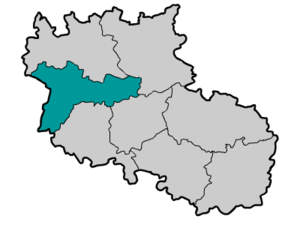
The territory of the former Ostrovsky district is located on the part of the territory of the modern Ostrovsky district (without the northern tip related to the Pskov district, and without the southern tip related to the Opochetsky district), as well as on the territory of the modern Pytalovsky district , Palkinsky district (without its northern half belonging to the Pskovsky uezd), Porkhovsky (only the southern part), Novorzhevsky (only the northern part) and Dedovichi (only the southwest part) districts of the Pskov region .
Geographical position
At the beginning of the 20th century, Ostrovsky Uyezd was located in the western part of the Pskov Gubernia and bordered on the Pskov Uyezd in the north, Porkhov Uyezd in the east, Opochetsk and Novorzhevsky Uyezds in the south and the Vitebsk Guberniya in the west (in the early 1920s this border became external in connection with Latvia gaining independence).
County Composition
- Burinsky volost
- Vyshhorodets volost
- Le Havre Parish [5]
- Kachanovsky volost
- Myasovskaya volost
- Openkovsky volost
- Pokrovskaya volost
- Prokshinsky volost
- Soninsky volost
- Tolkovo volost
- Turovets volost [6]
According to the data for 1914, Ostrovsky Uyezd included the following 12 volosts (in brackets - center):
- Vyshhorodets volost (v. Vyshhorodok - on the territory of the modern Vyshgorod volost of the Pytalovsky district )
- Gribulevsky volost (Gribuli village - on the territory of the modern Novousitovskaya volost of the Palkinsky district )
- Gusakovskaya volost (village Dulovka - in the territory of modern Volkovskaya volost of Ostrovsky district )
- Zherebtsovskaya volost (Berezhani village - on the territory of the modern ~ Berezhanskaya volost of the Ostrovsky district )
- Kachanovskaya volost (village Gorbunova-Gora) - on the territory of modern Rodovskaya (village Gorbunova Gora) and Kachanovskaya volosts in the Palkinsky district
- Koreshevskaya volost (v. Vybor - on the territory of the modern Vyborsk volost of the Novorzhevsky district )
- Lisinsky volost (s. Lisino) - on the territory of the modern ~ Gorayskaya , Gorodishchensky , partially ~ Berezhansky volosts of the Ostrovsky district
- Myasovskaya volost (village Lavrovo) - on the territory of the modern Vorontsov volost of the Ostrovsky district
- Prokshinsky volost (village of Naverezhye - on the territory of modern Pozherevitskaya volost of the Dedovichi district )
- Soninsky volost (village of Krasnoye-Sosonye) - in the territory of modern Slavkovsky volost of the Porkhov district (village of Krasnoye Sosonye) and Shikovskaya volost of the Ostrovsky district (village of Sonino)
- Tolkovo volost (Tolkovo village) - on the territory of modern Linov and Nosov volosts of the Pytalovsky district and Berezhanskaya volost of the Ostrovsky district (Tolkovo village)
- Turovets volost (v. Veski - on the territory of the modern Veska volost of the Novorzhevsky district [7]
The structure of the Ostrovsky district of the Pskov province of the RSFSR of the period 1924 - 1927 included 5 enlarged volosts: [8]
- Volodarsky volost (center - Ostrov city)
- Krasnososenskaya volost (center - v . Krasnoye Sosonye )
- Lena volost (center - suburb. Choice )
- Myasovskaya volost (center - v . Lavrovo )
- Khalturinsky volost (center - v . New Usitva )
Population
National composition of the county in their native language (1897 census): [9]
- Velikorosy - 156,227 people. (96.5%)
- Latvians - 2,929 people (1.8%)
- Poles - 893 people (0.55%)
- Jews - 889 people (0.55%)
- The Germans - 398 people. (0.25%)
- Estonians - 275 people. (0.17%)
- Gypsies - 123 people (0.08%)
- total - 161 877 people. (100.0%)
Notes
- ↑ First general census of the population of the Russian Empire in 1897. Available population in the provinces, counties, cities of the Russian Empire (without Finland) . Date of treatment November 15, 2009. Archived on February 28, 2012.
- ↑ Memorial book of the Pskov province 1913-1914 (1914psk.pdf)
- ↑ Island, county-level city of the Pskov province // Brockhaus and Efron Encyclopedic Dictionary : in 86 volumes (82 volumes and 4 additional). - SPb. , 1890-1907.
- ↑ Eastern Europe in the years 1917-1922. Civil war in Russia
- ↑ In the source - Govorovskaya - I mean Gavrovskaya
- ↑ Ostrovsky district of the Pskov province. Vrev.ru
- ↑ Memorial book of the Pskov province 1913-1914 (1914psk.pdf)
- ↑ Administrative-territorial division of the Pskov region. "(1917-2000). Reference book. Book 1. - Pskov, 2002 P.37 - 38 ( djvu )
- ↑ Ostrovsky Uyezd - entire // First General Census of the Russian Empire in 1897. Distribution of the population by mother tongue and counties of 50 provinces of European Russia. Demoscope
Links
- Map of the Ostrovsky district of the Pskov province. (1903). Date of treatment February 16, 2009. Archived February 29, 2012.
- Old maps of Ostrovsky county