Toropeck district ( Russian dore. Toropeck district [2] ) - the administrative unit of the Pskov province of the Russian Empire . The area occupied 6,241.3 km² (5390.8 sq. Mile), the population as of 1897 - 97,840 people. [3] The county town was Toropets .
| Toropetsk district (Toropetskiy uҍzd) | |
|---|---|
| A country | |
| Province | Pskov province |
| County town | Toropets |
| History and Geography | |
| Date of formation | 1777 |
| Area | 6,241.3 km 2 km² |
| Population | |
| Population | 96 472 [1] ( 1897 ) people |
 | |

Content
History
At the time of feudal fragmentation, Toropets was the center of the Principality of Toropets . After the capture of the principality by the Lithuanian prince Algerd, this territory until 1503 was part of the Grand Duchy of Lithuania .
As part of the Russian Empire
Since 1708, the city of Toropets was part of the Ingermanland province . In 1777, the Toropetsky district became part of the newly created Pskov governorate (from 1796 - the Pskov province). By 1897, the county consisted of 1 city, 1614 villages and 938 small towns. The main occupation of the inhabitants was tillage , and the handicrafts were poorly developed. There were also a number of factories and plants (at the end of the XIX century - 115) .. [3]
In the second half of the 19th century , the Zemsky post office operated in Kholmsky district. [four]
Under Soviet
Toropetsky district ceased to exist on July 18, 1927 . Its territory became part of the Toropetsky district of the Velikoluksky district of the Leningrad region (which then included the territory of the abolished Pskov province. Subsequently, the area several times passed into various administrative units. [5]
Current situation
At the moment, the territory of the former county is part of the Tver region (parts of the Toropetsk , Andreapolsky and Zapadnodvinsky districts) and the Pskov region ( Kuninsky district ).
Geographical position
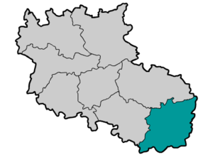
At the beginning of the 20th century, the Toropetsky district was located in the southeastern part of the Pskov province and bordered in the north with Kholmsky district , with Velikoluksky district in the west, with Vitebsk province ( Velizhsky district ) in the south, with Smolensk province ( Belsky district ) in the south east and Tver province ( Ostashkovsky district ) in the northeast.
County Composition
- Baranetsk-Ozeretskaya volost
- Vsteselovsky volost
- Vkhonovo volost
- Zizhetsky volost
- Kazarinsky volost
- Kudryavtsevsky volost
- Pozhinsky volost
- Starcova volost
- Timinsky volost
- Benecki volost
The composition of the county in 1907
1. Siverstkaya
2. Platichenskaya
3. Vsteselovskaya
4. Lomovskaya
5. Klinskaya
6. Prilutskaya
7. Benitskaya
8. Pozhinskaya
9. Ponizovskaya
10. Old
11.Tour
12.Baranetsko-Ozeretskaya
13.Khorvostevskaya
14.Nevorozhskaya
15.Vshonovskaya
16. Turovskaya [6]
Notes
- ↑ First general census of the population of the Russian Empire in 1897. Available population in the provinces, counties, cities of the Russian Empire (without Finland) . Archived February 29, 2012.
- ↑ Memorial book of the Pskov province 1913-1914 (1914psk.pdf)
- ↑ 1 2 Toropets // Brockhaus and Efron Encyclopedic Dictionary : in 86 volumes (82 volumes and 4 additional). - SPb. , 1890-1907.
- ↑ Great Philatelic Dictionary
- ↑ City of Toropets. Informational portal. FROM TOROPETSK PRINCIPLE TO TOROPETSK DISTRICT
- ↑ Pskov province: data set estimated-statistical. research. - Pskov, 1901-1913. - Before the plag. : Statistical Dep. Pskov lips. Zemsky Council. T. 4: Toropetsky district, Vol. 1: Territory, population, land tenure. - 1907. - 303 p. . - 86 p. - ISBN http://elib.shpl.ru/en/nodes/16084-t-4-toropetskiy-uezd-vyp-1-territoriya-naselenie-zemlevladenie-1907#mode/inspect/page/103/zoom/6 .
Literature
- Galashevich A.A. Toropets and its environs . - M .: Art , 1972. - 136 p. - (The road to the beautiful ). - 60,000 copies.