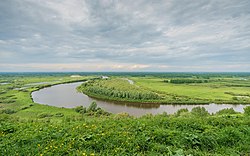
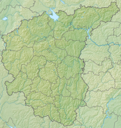
Klyazma - a river in the European part of Russia , the left tributary of the Oka . It flows through the territory of the city of Moscow ; Moscow [2] , Vladimir [3] , Ivanovo [4] and Nizhny Novgorod [5] regions.
| Klyazma | |
|---|---|
 | |
| Characteristic | |
| Length | 686 km |
| Pool | 42,500 km² |
| Water flow | 147 m³ / s (in the city of Kovrov ) |
| Watercourse | |
| Source | |
| • Location | Moscow Upland , 8 km to east of Lake Senezh |
| • Height | > 225 m |
| • Coordinates | |
| Mouth | Oka |
| • Location | 4 km to the NW from Gorbatov |
| • Height | 67 m |
| • Coordinates | |
| Location | |
| Water system | Oka → Volga → Caspian Sea |
| A country |
|
| Regions | Moscow region , Vladimir region , Ivanovo region , Nizhny Novgorod region |
| HWR Code | |
Content
Geography
The length is 686 km, the basin area is 42.5 thousand km². The average annual discharge of water in 185 km from the mouth, near the town of Kovrov , is 139–147 m³ / s. Food mostly snow. It freezes in November and opens in the first half of April.
The river originates within the Moscow Upland , near Solnechnogorsk at an altitude of more than 225 m above sea level [6] . It flows from the source to the southeast, through the territory of the Solnechnogorsk district [7] , and then along the border of the Molzhaninovsky district of Moscow, where it turns sharply eastward at the village of Cherkizovo . Then it flows past Sheremetyevo Airport and the villages of Melkisarovo , through the Klyazminskoe and Pirogovskoye reservoirs, where it mixes with the waters of the Volga. The shores in the upper Klyazma are high, the valley is narrow. At the confluence of the Klyazminskoye reservoir, the width of the river reaches 12 m. The Klyazma runoff is regulated below the reservoirs mentioned above, its width at the Klyazma platform of the Yaroslavl direction of the Moscow Railway is about 20 m.
It flows mainly through the Meshchersky lowland . Within Meshchera, the right bank of the river is significantly lower than the left. Below the Teza estuary on the low left bank begins the Balakhna Lowland , on the right a steep bank (up to 90 meters), belonging to the Gorokhovetsky spur of the Tsninsky shaft . The width in Noginsk is 50 m, in Vladimir it is 130 m. In some places Klyazma has a width exceeding 200 m. The maximum depth is 8 m, prevailing is small (1–2 m). In some places, the river cuts through limestone strata. The bottom is clay, sometimes sandy.
On the left bank between Kovrov and the Teza estuary there is the state nature reserve “Klyazminsky” (before 1978 there were two local beaver-muskrat zakaznik reserves: Yuzhsky in Ivanovo and Kovrov in the Vladimir region).
On the Klyazma River, burial grounds of Fatyanovo culture were found in the Noginsk area (Bunkovsky cemetery), Orekhovo-Zueva (Verey cemetery), and the village of Shashev (Kovrov burial) [8] [9] .
Tributaries
(distance from the mouth)
- 14 km: river Suvoroshch (pr)
- 68 km: the river Luh (lv)
- 79 km: the river Istok (lv)
- 88 km: river Volshnik ( PR )
- 110.7 km: Tara River (pr)
- 111 km: the river Mstyorka ( PR )
- 135 km: Teza river (lv)
- 151 km: the river Shizhde
- 173 km: River Uvod
- 190 km: the river Nerekhta
- 244 km: river Sudogda
- 269 km: the river Nerl
- 285 km: River Rpen
- 326 km: Koloksha River
- 329 km: Shalovka Stream
- 336 km: Vorsha River
- 343 km: Undolka stream (Voronovka stream)
- 378 km: Fields River
- 396 km: Peksha River
- 416 km: the river Berezka
- 441 km: river Volga
- 445 km: Shchitka River
- 459 km: the river Kirzhach
- 466 km: the river Dubna
- 476 km: Vyrka River
- 481 km: the Drezna River
- 502 km: Vokhonka River
- 514 km: Plotnya River
- 516 km: the Sherna River
- 524 km: the river Zagrebka
- 526 km: the river Chernogolovka
- 526 km: the river Lavrovka
- 540 km: Shalovka River
- 551 km: Vorya River
- 577 km: river Ucha
- 640 km: Alba River
- 665 km: the river Radomlya
- 671 km: Chernavka River
The largest tributaries are: on the left — Ucha , Vorya , Cherna , Kirzhach , Peksha , Koloksha , Nerl , Uvod , Teza and Lukh ; on the right - Fields , Sudogda and Suvoroshch .
History
On the banks of the river and the entire basin, people have long settled. The archaeologists excavated the sites of an ancient Paleolithic man - the famous Sunghir , Mesolithic - for example, near the village of Saurovo near Pavlovsky Posad , many Neolithic (including the village of Big Bunykovo of the Noginsk district - the sites of Lyalovskaya and Fatyanovo cultures), the settlement of Dyakovo culture . In later times, the banks were inhabited by Finno-Ugric mecherias , Merya and Muroma (the languages of these tribes gave modern names to many tributaries of the river), and the first Slavic burial grounds in these places were found.
The development of the entire northeast of Russia , beginning with the Vladimir-Suzdal principality (XII century), is connected with the river and its tributaries. At this time, the river with its tributaries was used for navigation throughout its length, which made it possible to extend its influence far, and the Klyazma-Skhodnya-Moscow trade route , which was used before the Slavic settlement, developed an economic basis.
Since the development of crafts (XVII century), the river has concentrated a lot of paper, ceramic and especially textile production, first handicraft, and later factory and factory.
In 1937, as part of the industrialization of the USSR, the construction of the Moscow Canal was completed, the headwaters of the Klyazma were blocked by the Pirogov dam, which formed the Klyazminskoe reservoir . The runoff through the dams, simultaneously generating electricity , became regulated and fed by the waters of the upper Volga and the rivers of the north of the Moscow Region.
In 1941, the construction of two hydropower plants near Vladimir and Kovrov was stopped, but soon after the beginning of the war. The legacy of construction at the site of the Kovrov station is the Pakinskaya colony.
In the 70s of the 20th century, the project of the Eastern shipping canal on the outskirts of Moscow was considered.
River today
Such large cities as Khimki , Dolgoprudny , Shchelkovo , Korolev , Losino-Petrovsky , Noginsk , Pavlovsky Posad , Orekhovo-Zuevo , Sobinka , Vladimir , Kovrov , Vyazniki , Gorokhovets are located on the river.
The river provides with water both numerous productions and residents of large settlements in the middle and lower reaches.
It is navigable 267 km from the mouth to Vladimir, used for the transport of goods by barges (including the sands washed here). Full navigation in the middle reaches is limited by the shallow depth and rocky bottom of the section between Kovrov and Mstera.
There is a cargo port in Vyazniki, a historic shipyard in Gorokhovets [10] .
Waterworks
Dams :
- in the village of Lunyovo ( Solnechnogorsk district );
- Pirogovskiy waterworks in the village of Pirogovskiy ;
- in the village of Tarasovka ;
- in the neighborhood New slides, the city of Korolev ;
- Amerovo village near the town of Shchelkovo ;
- the village of Sverdlovsk ;
- the remains of a dam in the city of Losino-Petrovsky (at the sanatorium "Monino");
- in the village of Obukhovo ;
- in Noginsk, there is a concrete dam about 2.5 m high with six adjustable spillways and a coastal spillway.
Effluents: sewage treatment plants of the Shchelkovskaya, Obukhovskaya , Noginskaya, Pavlovo-Posadskaya and Orekhovo-Zuyevskaya water supply and sewer systems.
In the Moscow Region, stationary hydrological observations are conducted by the departments of the Moscow Center for Hydrometeorology and Environmental Monitoring [11] :
- integrated hydrological station (including a hydrochemical station with two sections) in Orekhovo-Zuevo;
- hydrochemical observation point in Shchelkovo (three sections);
- hydrochemical station in Pavlovsky Posad (two sections).
Bridges and overpasses
- Overpass for airplanes at Sheremetyevo airport
- Sheremetyevsky highway
- Bridge in Klushin (new route Moscow - St. Petersburg)
- Bridge in Maydarov (new highway Moscow - St. Petersburg)
- International Highway Bridge
- Dolgoprudnensky railway bridge
- Dmitrovsky Highway Bridge
- Railway bridge on the line Vladimir - Tumskaya
- Bridge on the southern bypass of Vladimir highway M7 (1998)
- Bridge named after the 850th anniversary of Vladimir (1958)
- Bridge on the highway M7 ( Penkino )
- Railway Kovrovsky bridge
- Automobile Kovrovsky bridge
- Vyaznikovsky bridge
- Gorokhovets bridge ( highway M7 )
- Railway bridge ( Galicia )
| Other, small bridges | |
|---|---|
| Railway bridge near Bukharov | |
| Bridge in Bolkashin | |
| Bridge in Nikolsky | |
| Bridge in the pension "Morozovka" | |
| Bridge on Lyalovsky highway | |
| Pedestrian bridge on the street Levoberezhnaya (Mendeleevo village) | |
| Bridge on Pionerskaya street (Mendeleevo village) | |
| Pedestrian bridge to the site of the MAI | |
| Bridge near the village of Horizon | |
| Bridge near the village of Iskra | |
| Bridge near the village of Iskra | |
| Bridge in the village of Lunyovo | |
| Bridge in the village of Nadezhda | |
| Isakov Bridge | |
| Ostashkovskogo highway bridge (Pirogovo village, Central Street) | |
| Pirogovskogo highway bridge (entrance to the village of Pirogovsky) | |
| Akulovsky bridge | |
| Klyazminsky railway bridge | |
| M8 highway bridge | |
| Railway Bridge (Fryazinskaya branch) | |
| Bridge in the village Forest Glades | |
| Pedestrian bridge in Korolyov (microdistrict Pervomaysky) | |
| Bridge in Korolyov (microdistrict Bolshevo) | |
| Pedestrian bridge in Korolyov (Burkovo village) | |
| Bridge in Korolev (dam bridge in the neighborhood of New Slides) | |
| Bridge near the village of Krasnoznamensky (Schelkovsky district) | |
| Pedestrian bridge in Schelkovo (Sokolovskaya street - Serova street) | |
| Pedestrian bridge in Schelkovo (Pushkin street - Serova street - Talsinskaya street) | |
| The bridge in Shchelkovo (old; in the autumn of 2014 closed for restoration) | |
| Fryanovsky Highway Bridge R-110 highway (Schelkovo, Proletarsky Avenue) | |
| Zheleznodorozhny Shchyolkovsky Bridge (dead-end branch from Schelkovo station to Schelkovsky mine department) | |
| Pedestrian bridge in the area Potapova to the village Amerevo (Schelkovo) | |
| The bridge in Shchelkov along Chkalovskaya street to Rabochaya street in the villages of Kozhino and Amerevo | |
| A-103 highway bridge between Aniskin and the Biocombinat settlement (Schelkovsky district) | |
| Moninsky bridge | |
| Elninsky bridge | |
| Decembrists Bridge (Noginsk) | |
| Zakharovsky Bridge (Noginsk) | |
| Railway bridge of the Noginsk industrial railway transport enterprise (PPZHT) | |
| Bridge highway M7 (Theologian) | |
| Victory Bridge (Pavlovsky Posad) | |
| Gorodkovsky pedestrian bridge (Pavlovsky Posad) | |
| Gorodkovsky Bridge (Pavlovsky Posad) | |
| Elektrogorsky railway bridge (Pavlovsky Posad) | |
| Suspended pedestrian bridge (Pavlovo-Posadsky district) | |
| Gagarinsky pedestrian bridge (Orekhovo-Zuyevo) | |
| Zuevsky Bridge (Orekhovo-Zuyevo) | |
| Old bridge (renovated) (Orekhovo-Zuyevo) | |
| Parkovsky Bridge (Orekhovo-Zuyevo) | |
| Krutovsky pedestrian bridge (Orekhovo-Zuyevo) | |
| Horodyshchensky railway bridge | |
| Bridge on the road Pokrov - Markovo | |
| Bridge on the road Petushki - Krutovo | |
| Bridge in the area of Kosterov (military facility) | |
| Sobinsky bridge |
Ecology, fauna, vegetation
From the city of Shchelkovo to the tributaries of the Vladimir region both the water and its inhabitants are unsuitable for eating, and the water is also unsuitable for swimming.
The Klyazma is heavily polluted in its upper reaches [12] , but still quite rich in fish ( bream , ide , podust , chub , perch , pike , roach , ruff , burbot , gudgeon , bleak , chub , rotan, loach, crucian). Nowadays in Klyazma there is almost no catfish and sterlet , which the river was famous for in the XIX and XX centuries.
Coastal vegetation is represented by various types of willows and sedges , chastuhoy , reeds , rogoza , stinging nettles , forest geraniums , a series of threefold , aquatic vegetation - duckweed , water lily , paprika , elodea Canadian , kamolistnikom , various kinds of rdesta .
The river is available for kayaking from May to September.
Notes
- ↑ Surface water resources of the USSR: Hydrological knowledge. T. 10. Verkhne-Volzhsky district / ed. V.P. Shaban. - L .: Gidrometeoizdat, 1966. - 528 p.
- ↑ Klyazma ( № 0002806 ) / The register of names of geographical objects for the territory of the Moscow region as of 03/20/2019 // the State Catalog of Geographical Names. rosreestr.ru.
- ↑ Klyazma ( № 0002806 ) / Register of the names of geographical objects on the territory of the Vladimir region as of 11/22/2018 // State Catalog of Geographical Names. rosreestr.ru.
- ↑ Klyazma ( № 0002806 ) / The register of names of geographical objects for the territory of the Ivanovo region as of 02.2.2019 // State Catalog of Geographical Names. rosreestr.ru.
- ↑ Klyazma ( № 0002806 ) / The register of names of geographical objects for the territory of the Nizhny Novgorod region as of 03/20/2019 // the State Catalog of Geographical Names. rosreestr.ru.
- ↑ O-37-135-Cb Map Sheet - FSUE “GOSGISTSENTR”
- ↑ p. Klyazma (Inaccessible link) . Public cadastral map . Rosreestr. The appeal date is April 7, 2015. Archived March 7, 2016.
- Archaeological research in the RSFSR 1934-1936. - L. , 1941. - p. 87.
- ↑ Dubynin A. F. Kovrovsky fatianovsky burial ground // KIIMMK. - Vol. 53. - M. , 1954. - S. 50-54 . www.archaeology.ru . The appeal date is January 24, 2019.
- ↑ Lotsiya Klyazma River from the mouth to Vladimir . www.boatclub.ru . The appeal date is January 24, 2019.
- ↑ Moscow CGMS-R . The appeal date is January 24, 2019.
- ↑ Characteristics of pollution of river waters of the Klyazma basin in the Moscow region / V.M. Yashin (Not available link) . www.msuee.ru . The appeal date is September 28, 2007. Archived September 28, 2007.
Links
- Klyazma // The Great Soviet Encyclopedia : [in 30 t.] / Ch. ed. A. M. Prokhorov . - 3rd ed. - M .: Soviet Encyclopedia, 1969-1978.
- Klyazma // Encyclopedic Dictionary of Brockhaus and Efron : 86 tons. (82 tons and 4 extra.). - SPb. , 1890-1907.
- Klyazma // Dictionary of modern place names / Rus. geogr. oh Mosk. Centre; Under total ed. Acad. V.M. Kotlyakov . Institute of Geography RAS . - Yekaterinburg: U-Factory, 2006.
- The Polya River - the Klyazma River (from Moscow to the Vladimir Region ~ up to 60 km): rafting report (PHOTOS) . www.skitalets.ru . The appeal date is January 24, 2019.
- Klyazma, Teza - mills and strugi. Story. tsiplev.ucoz.ru . The appeal date is January 24, 2019.