Khaipudyrskaya Bay [1] is a shallow bay in the southeast of the Pechora Sea off the coast of the Nenets Autonomous Okrug .
| Khaipudyr Bay | |
|---|---|
| Characteristics | |
| Bay Type | Lip |
| The average tide | 1m |
| Average depth | 1-2 m |
| Location | |
| Upstream waters | Pechora Sea , Barents Sea , Arctic Ocean |
| A country |
|
| The subject of the Russian Federation | Nenets Autonomous Okrug |
| Area | Zapolyarny district |
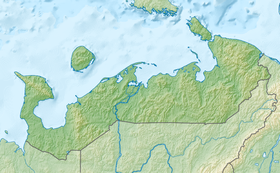
The length of the lip is 46 km, the width at the entrance is about 15 km, in the middle part - about 33 km. At the same time, the depth on most of them does not exceed 1-2 m.
Shores - Bolshezemelskaya tundra with permafrost . The western shores are high and steep, eastern, on the contrary, low, with shallows . From the Khaipudyrskaya Bay to the mouth of Tsilma stretches the hill of the Earth Ridge .
Tides in the bay are semidiurnal, up to 1 m high.
The bay has developed fishing ( cod and other species of northern marine fish ), as well as fishing for beluga whales and seals .
The rivers More-Yu and Korotaikha flow into the Khaipudyr Bay.
Notes
- ↑ Khaipudyr Bay // Dictionary of the names of hydrographic objects of Russia and other countries - members of the CIS / ed. G.I. Donidze. - M .: Kartgeotsentr - Geodezizdat, 1999. - S. 323. - ISBN 5-86066-017-0 .
Literature
- Big Encyclopedic Dictionary: In 2 volumes / Ch. ed. A. M. Prokhorov - M .: Sov. Encyclopedia, 1991. - T. 2. - P. 584. - 768 p. - 2,000,000 copies. - ISBN 5-85270-044-4 (t. 2.).