Niers ( German: Niers ) or Ners ( Dutch: Neers ) [1] - a river in Germany and the Netherlands , the right tributary of the Meuse . On the territory of the Dutch province of Limburg there is a mouth section of the river, along the rest of the length it flows along the German land of North Rhine-Westphalia [2] [3] .
| Niers (Ners) | |
|---|---|
| him. Niers , the Netherlands. Neers | |
 Niers River, Weeze , Germany Niers River, Weeze , Germany | |
| Characteristic | |
| Length | 117.6 km |
| Pool | 1380.63 km² |
| Watercourse | |
| Source | |
| • Location | Erkelenz |
| • Height | 73 m |
| • Coordinates | |
| Mouth | Maas |
| • Location | Gennep |
| • Height | 9 m |
| • Coordinates | |
| Location | |
| Water system | Meuse → North Sea |
| Country |
|
| Regions | North Rhine-Westphalia , Limburg |
The pool area is 1380.63 km² [4] . The river is 117.6 km long [4] . The height of the source is 73 m [5] , the mouth is 9 m [5] .

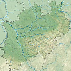
The source is located near the city of Erkelenz south of Monchengladbach . The river flows through Monchengladbach, Viersen , Wachtendonk , Geldern , Goch . At the confluence of the rivers Meuse and Nirs is the city of Gennep (province of Limburg , the Netherlands) [2] [3] .
Along the river there are many cycling [6] [7] and hiking routes.
On the river is the nature reserve in the town of Viersen [8] , as well as the Rydt , and castles.
Notes
- ↑ Reference Dictionary “Geographical Names of Germany”: I / comp. V. S. Buzykina ; ed. E. N. Bushueva . - M .: Publishing House " Science ", 1981. - S. 261. - 200 copies.
- ↑ 1 2 Germany: Geographic map: Scale 1: 1,000,000 / st. ed. L. N. Kolosova ; Ed .: G. A. Skachkova , N. N. Ryumin . - Omsk: Roskartografiya, Federal State Unitary Enterprise “ Omsk Cartographic Factory ”, 2007. - (World Countries “Europe”). - 2000 copies. - ISBN 5-9523-0015-4 .
- ↑ 1 2 Netherlands: Geographic map: Scale 1: 500,000 / st. ed. L. N. Kolosova ; ed. N. B. Trokhina . - Omsk: Roskartografiya, Omsk Cartographic Factory , 1993. - (Countries of the World "Europe"). - 5,000 copies.
- ↑ 1 2 Topographisches Informationsmanagement, Bezirksregierung Köln, Abteilung GEObasis NRW ( details (German) )
- ↑ 1 2 (DGK 5) in Topographisches Informationsmanagement, Bezirksregierung Köln, Abteilung GEObasis NRW ( details (German) )
- ↑ Niers-Radwanderweg ~ Niederrhein Tourismus (German) . niederrhein-tourismus.de . Date of treatment March 14, 2019.
- ↑ Kreis Viersen: Niers-Radwanderweg (German) . www.kreis-viersen.de . Date of treatment March 14, 2019.
- ↑ Chronik - Clörather Mühle: Ehemalige Wassermühle bei Viersen (German) . www.cloerather-muehle.de . Date of treatment March 14, 2019.
Literature
- Niers // Dictionary of geographical names of foreign countries / ed. ed. A.M. Komkov . - 3rd ed., Revised. and add. - M .: Nedra , 1986. - S. 243—261.
- : Burgen, Schlösser, Herrenhäuser an den Ufern der Niers. Boss, Kleve 1997, ISBN 3-9805931-0-X .
- Birgit Wilms, Heinz-Gerd Wöstemeyer: Im grünen Land der Niers. Von der Quelle bis zur Mündung. Mercator, Duisburg 2005, ISBN 3-87463-395-0 .
Links
Information:
- GeoNames.org . www.geonames.org . Date of treatment March 14, 2019.
- TIM-online 2.0 (German) . www.tim-online.nrw.de . Date of treatment March 14, 2019.
- TIM-online (German) . www.bezreg-koeln.nrw.de . Date of treatment March 14, 2019.
Information, many photos:
- Die Niers und Umgebung I (German) . www.niederrhein-maas.de . Date of treatment March 14, 2019.
- Die Niers und Umgebung II (German) . www.niederrhein-maas.de . Date of treatment March 14, 2019.
Story:
- SAGEN.at - NIERSQUELLE, Erkelenz-Kuckum (German) . www.sagen.at . Date of treatment March 14, 2019.