Suida ( Fin. Suijanjoki ) is a small river in the Gatchina district of the Leningrad region , the left tributary of the Oredezh . Length - 63 km with an average channel width of 5-8 m and a depth of 1-1.5 m.
| Suida | |
|---|---|
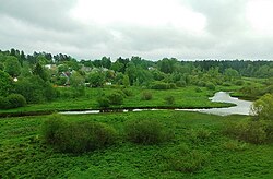 Suida River Valley Suida River Valley | |
| Characteristic | |
| Length | 63 km |
| Pool | 475 km² |
| Watercourse | |
| Source | |
| • Location | Izhora Upland |
| • Coordinates | |
| Mouth | Oredezh |
| • Coordinates | |
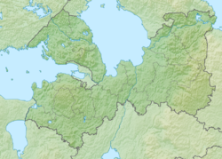
| Location | |
| Water system | Oredezh → Luga → Luga Bay → Gulf of Finland → Baltic Sea |
| A country |
|
| Region | Leningrad region |
| Area | Gatchina district |
| HWR code | |
The river originates from a high bog 3 km northwest of the village of Tikhkovitsy . Its basin is a slightly wavy moraine plain with separate ridges of hills; covered with shrubs and forests, swampy in places, near the villages the area is occupied by meadows and arable land. The river is very winding, meandering in a weakly dissected valley with a width of 50-100 (and up to 400-450 m), which in some places is swampy and rugged by elders. In the area of the village of Mill , between the villages of Myza and Krasnitsa and other shores, steep heights up to 10-15 m; rifts stretch in the vicinity of the villages of Pogost and Kovshovo ; in the village of Mill, the river is blocked by the dam of the former mill and forms a spill. Over the past 16 km, the coast is covered with forest, where blockages are possible; flows into Oredezh 112 km from its mouth.
The main direction of the river flow is from west to east. The main tributaries: the Kobrinka river, Zaborsky stream.
On the map of the St. Petersburg province of J.F. Schmitt, 1770 is designated as Syuda , and in the upper reaches, as Tikhovitsa .
Water registry data
According to the state water register of Russia, it belongs to the Baltic Basin District , the water sector of the river is Luga, and there is no river sub-basin of the river. It belongs to the river basin of the Narva River (the Russian part of the basin) [2] .
According to the geographic information system of water management zoning of the territory of the Russian Federation, prepared by the Federal Agency for Water Resources [2] :
- The code of the water body in the state water registry is 01030000512102000025880
- The code for hydrological knowledge (GI) - 102002588
- Pool code - 01.03.00.005
- GI Volume Number - 2
- GI Issue - 0
Notes
- ↑ Surface Water Resources of the USSR: Hydrological Understanding. T. 2. Karelia and the North-West / ed. E.N. Tarakanova. - L .: Gidrometeoizdat, 1965 .-- 700 p.
- ↑ 1 2 State Water Register . SUIDA . textual.ru . Ministry of Natural Resources of Russia (March 29, 2009). Date of treatment December 20, 2018. Archived March 29, 2009.