Filliersdorp [1] ( africa. and English. Villiersdorp ) is a city in the southwestern Republic of South Africa , in the territory of the Western Cape . It is part of the Oberberch district . It is part of the local municipality of Tivatersclof .
| City | |
| Filirsdorp | |
|---|---|
| africa. and English. Villiersdorp | |
 | |
| A country | |
| Provinces | Western Cape |
| Area | Oferberch |
| Local municipality | Tivatersclof |
| History and Geography | |
| Founded | 1844 |
| Area | 2.89 km² |
| Center height | 336 m |
| Timezone | UTC + 2 |
| Population | |
| Population | 10 004 people ( 2011 ) |
| Digital identifiers | |
| Telephone code | +27 28 |
| Postcode | 6848 |
Content
- 1 History
- 2 Geographical location
- 3 Climate
- 4 population
- 5 Transport
- 6 See also
- 7 notes
History
The settlement, from which the city later grew, was founded by Peter Hendrick de Philliers in 1844 on the grounds of the Radeyn farm. In 1901, Philliersdorp was given the status of a municipality [2] .
Geographical position
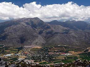
The city is located in the southwestern part of the province, in the valley of the same name, north of the Tivatersclof reservoir, approximately 56 kilometers (in a straight line) east of Cape Town , the provincial capital. The absolute height is 336 meters above sea level [3] .
Climate
The climate is characterized as warm Mediterranean ( Csb in the Köppen climate classification ). The average annual temperature is 15.6 ° C. The average temperature of the coldest month (July) is 10.8 ° С, the hottest month (February) is 20.4 ° С. The estimated long-term rainfall is 804 mm [4] .
Population
According to the 2011 official census , the population of Philliersdorp was 10,004 people, of which men were 50.8%, women were 49.2%, respectively. In racial terms, color made up 44.67% of the city’s population, blacks - 40.29%, whites - 12.5%, Asians (including Indians ) - 0.2%, representatives of other races - 2.33%. The most common languages among the townspeople were: Afrikaans (56.54%), scythe (24.56%), Sesotho (12.81%) and English (3.44%) [5] .
Transport
The regional highway R43 passes through the city. There is a train station. The nearest airport is Worcester [3] .
See also
- Grabow
- Hendendal
Notes
- ↑ Republic of South Africa. Reference map (scale 1: 2 500 000). - GUKG, 1980.
- ↑ Raper, RE Dictionary of Southern African Place Names . - HSRC.
- ↑ 1 2 Villiersdorp, South Africa Page . Fallingrain Global Gazetteer. Date of treatment December 19, 2018.
- ↑ Climate: Villiersdorp (English) . Climate-Data.org. Date of treatment December 19, 2018.
- ↑ Villiersdorp (English) . Census 2011. Date accessed December 19, 2018.