Usan is a tribal union on the territory of Ullyndo Island and adjacent islands during the period of the Three Korean States in the VI – IX centuries.
| Tribal Union ( Silla vassal 512-892) | |
| Usan | |
|---|---|
| 于 山 (우산) | |
 | |
??? - 935 | |
| Capital | Todon |
| Religion | shamanism |
| Square | 73 km² |
| from 512 侯 (Howe) | |
| • 512-531 | Kim isabu |
Prehistoric korea |
Chronology |
History
According to historical records from the Three States of Korea : Goguryeo , Baekche and Silla - Samguk Sagi , the Usan tribal alliance was conquered by Kim Isabu in 512. The records describe the legend of how Kim Isabu (military commander and politician) used mockups in the form of wooden lions or tigers to conquer the inhabitants when they conquered Ullyndo Island.
The tribal union was rarely mentioned in historical chronicles, but it is assumed that it existed after 512 years, paying Silla , one of the three Korean states, from time to time a symbolic tribute to mollusks, dried fish and shrimp [1]
In 892, Ousan declared his independence and existed until his accession to Koryo in 935. The alliance was transferred to the gunas from the Pak clan, which was soon overthrown and the power again passed to the local nobility. Usan’s further status is not known. However, it is known that in 1404, Usan was part of Joseon and sent two panhanxons for an expedition to conquer the state of Tamla .
The Usan-GUK consisted of Ullyndo and Usan-do. Koreans believe that Usan-do is Liankur rocks (Tokdo in Korea, Takeshima in Japan), because old Korean geographic records indicate that Ulleundo and Usando can see each other only on a clear day, although some Japanese dispute the interpretation of some records
According to the chronicles, Sejong (van Joseon) , Goryeosa and Mangi Yoram, Usan was located on the islands of Ullyndo and Usando . At the same time, one of the names of Usando is Liancourt Island (Tokdo in Korea, Takeshima in Japan), for which there is a dispute.
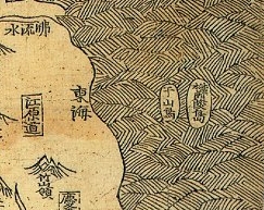
Old Korean cards
- Usan
Joseon map (1530): Ullyndo (鬱 陵 島) and Usan (于 山 島)
廣 輿 圖 (Gwang Yeodo, 1737-1776)
This map showed Ullyndo with a small island on its eastern shore, designated as the so-called “Usando,” (所謂 于 山 島) .Kim Jong-ho "Daedongyeojido" (1861): East Ullyndo (鬱 陵 島) and Usando (于 山)
Map of the Korean Empire : Ullyndo (鬱 陵 島) and Usan (于 山)
Notes
- ↑ 한국사 데이터베이스 unopened . db.history.go.kr. Date of treatment January 3, 2019.