Gualeguaychu [1] ( Spanish: Río Gualeguaychú ) - a river in Argentina , the right tributary of the Uruguay river. The length of the river is about 250 kilometers [2] . The catchment area of the river is 6690 km² [2] .
| Gualeguaychu | |
|---|---|
| Spanish Río Gualeguaychú | |
 | |
| Characteristic | |
| Length | 250 km |
| Pool | 6 690 km² |
| Watercourse | |
| Source | |
| • Coordinates | |
| Mouth | Uruguay |
| • Coordinates | |
| Location | |
| Water system | Uruguay → La Plata → Atlantic Ocean |
| A country |
|
| Region | Entre Rios |
| Areas | Colon , Uruguay , Gualeguaychu |
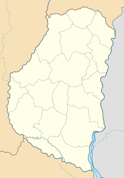
The river originates in the Colon Department of the Entre Rios province east of the city of Villaguay [1] , and flows south, approximately parallel to the Uruguay River, 20-30 km from it. In the Department of Gualeguaychu, it flows through the administrative center of the department of the city of Gualeguaychu , after which it turns east and flows into Uruguay [3] . The width of the river near the mouth is 140 meters [3] .
It flows along a lowland composed of sedimentary rocks, the heights of which do not exceed 100 meters above sea level. The average annual rainfall is 1050 mm. The climate is humid, the average temperature is 18 ° C. Nature is represented by cereal steppes, in some places the remains of the selva are preserved [2] .
The main tributaries are San Miguel, Hena , San Antonio, El Sauke, El Gato and Gualeyan [2] .
The maximum water discharge at the Puerto Gualeguaychu station was 4060 m³ / s in March 1978 [4] .
Notes
- ↑ 1 2 Map sheet H-21-B (Yu.P.) .
- ↑ 1 2 3 4 Cuenca No. 46. Cuenca del río Gualeguaychú
- ↑ 1 2 Map sheet I-21-A (Yu.P.) .
- ↑ Díaz EL Duarte OC Estudio hidrogeológico de la cuenca del Río Gualeguaychu con fines de riego de arroz. República Argentina. / M. Olmo Alarcón, JA Lopez Geta . Actualidad de las Técnicas Geofísicas aplicadas en Hidrogeología. - Instituto Tecnológico Geominero de España, 2000. p. 145-150