Tabuaeran ( English Tabuaeran ) - an atoll in the northern part of the Line archipelago ( Republic of Kiribati ). The second name is Fanning Island . The population of the atoll is 1960 people ( 2010 ). The administrative center is Paelau .
| Tabuaeran | |
|---|---|
| English Tabuaeran | |
 | |
| Specifications | |
| total area | 33.73 km² |
| Highest point | 3m |
| Population | 1960 people (2010) |
| Population density | 58.11 people / km² |
| Location | |
| Water area | Pacific Ocean |
| A country |
|
| Region | Line Islands |

Content
Etymology
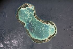
The name of the island, Tabuaeran , has Polynesian roots and comes from the word “ tabuaerangi ”, which translates as “ sacred footprint ” (the external similarity of the atoll and footprint is clearly visible).
Geography
The atoll is about 250 km from Christmas Island , which lies to the northwest. Tabuaeran is 17.6 km long and 11.2 km wide. The area of the island is 33.73 km². In the center of the island is a lagoon in which reef fish, mollusks and algae are bred. The average depth of the lagoon is 4.8 m. The island is surrounded by a coral reef.
History
Tabuaeran is located 1450 km (900 miles) from the Hawaiian Islands , thereby being one of the closest islands to the American archipelago. It is possible that during the settlement of the Hawaiian Islands, the atoll served as an intermediate point for the Polynesians from the islands of Cook and Tonga , although during the discovery of Tabuaeran by the Americans, the island, like other atolls in the Line archipelago, was uninhabited. During archaeological research on the atoll, traces of Polynesian ceremonial sites, or marae , as well as fishing hooks were found.
In 1798, the captain of the American Betsy whaling ship, Edmund Fanning , sailed across the central Pacific Ocean with a load of seal skins that were taken aboard on the Juan Fernandez Islands on their way to China . Once at the Marquesas Islands in French Polynesia , the captain headed west. At 3 a.m. on June 11, the crew of his ship noticed land on the horizon. It turned out to be an atoll, which was later named after the captain of the whaling ship - Fanning Island . Replenishing provisions, the ship sailed further northward. At noon the next day, Fanning discovered another island in the Line archipelago. It was named Washington Island , after the President of the United States .
In 1846, the Scottish man William Greig settled on the island of Fanning with his wife from the island of Manihiki . Using the labor of workers from Manihiki Island, he planted coconut palms on the island and started producing palm oil and later copra, which was exported. In the 19th century , guano was mined on Tabuaeran, which was then transported by ships to Honolulu . In 1902, a British company built a transoceanic cable station in the Napari settlement on the California - Fiji - New Zealand line . In 1936, the island was purchased by Burns Philip & Co. , which had many coconut plantations on other Pacific islands. In 1964, the cable station was closed, and the building itself was leased to the University of Hawaii, which was engaged in the study of the Pacific Islands. Lease of the island continued until 1981 . After gaining independence by the British colony of Gilbert Island, Fanning Island became part of the Micronesian Republic of Kiribati and was officially renamed the Tabuaeran Atoll.
Population
| No. | Settlement | English name | Population, people (2010) [1] |
|---|---|---|---|
| one | Tereitaki | Tereitaki | 346 |
| 2 | Betania | Betania | 175 |
| 3 | Paelau | Paelau | 200 |
| four | Aontenaa | Aontenaa | 190 |
| five | Tereitannano | Tereitannano | 168 |
| 6 | Aramari | Aramari | 244 |
| 7 | Terine | Terine | 453 |
| eight | Ethene | Ethen | 184 |
| Total | Total | 1960 |
Economics
The main occupation of local residents is the production of copra , pigs and chickens are raised. Tourism is developed.
Notes
- ↑ Kiribati Census Report 2010 Volume 1 . National Statistics Office, Ministry of Finance and Economic Development, Government of Kiribati. Archived on August 10, 2014.