Overyanovskoe [1] [2] ( Averyanovskoe Lake or Buriaki ; Ukrainian Over'yanivske Lake ) - a lake located in the territory of the Novotroitsky district . The area of the water mirror is 0.94 km² [3] . The type of general mineralization is salty . The origin is estuary . The hydrological regime group is closed .
| Lake | |
| Overyanovskoe | |
|---|---|
| Ukrainian Over'yanivske lake | |
| Morphometry | |
| Dimensions | 1.5 × max. 0.75 km |
| Square | 0.94 km² |
| Hydrology | |
| Type of mineralization | salty |
| Salinity | 20 ‰ |
| Location | |
| A country |
|
| Region | Kherson region |
| Area | Novotroitsky district |
Geography
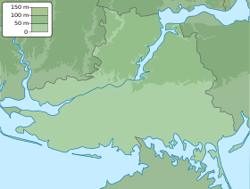
Included in the Genic (Chongar-Arabat) group of lakes. Length - 1.5 km. The average width is 0.6 km, the largest is 0.75 km.
The lake has an oblong, rounded shape extending from north to south. It is located on the Sisivash lowland and is separated from the Sivash Bay (western part) of the Sea of Azov by a permanent crib (2 km wide). The shores are mostly gentle. Solonchaks adjoin the lake.
To the east is the village of Overyanovka [1] .
Mixed food: seawater, groundwater near cliffs and bottom sources, as well as fresh water from self-flowing artesian wells . In dissolved salts, table salt predominates, which usually sets in late summer. Bottom sediments are dense gray silt . Intensively overgrown with higher aquatic vegetation, where water comes from artesian wells, algae are developed at groundwater outlets.
Fish are found, for example, Pilengas , crucian carp [4]
Notes
- ↑ 1 2 Map sheet L-36-69 Thunder . Scale: 1: 100,000. State of the terrain for 1987. 1991 edition
- ↑ Map sheet L-36-XVII .
- ↑ About hardening of the river and water, which is up to the water objects (Ukrainian) (January 6, 1998).
- ↑ Fishermen Forum
Sources
- Surface water resources of the USSR. Volume 6: Ukraine and Moldova. Issue 4: Crimea. Under. ed. M. M. Eisenberg and M. S. Kaganer. - L. Hydrometeoizdat. 1966.344 s. - 275 p.
- Lakes of the Kherson region