Kuria ( English Kuria ) - an atoll in the northern part of the Gilbert Islands in the Pacific Ocean . Located 12 km northwest of Aranuk Atoll.
| Curia | |
|---|---|
| English Kuria | |
 | |
| Specifications | |
| Number of islands | 2 |
| Largest island | Boariki |
| total area | 15,477 km² |
| Highest point | 3m |
| Population | 980 people (2010) |
| Population density | 63.32 people / km² |
| Location | |
| Water area | Pacific Ocean |
| A country |
|
| Region | Gilbert Islands |


Content
Geography
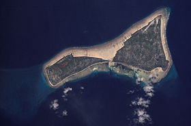
The atoll consists of two small islands, Boiriki and Oneeke , separated by a narrow strait. These islands are surrounded by a fringing reef, reaching a maximum width in the eastern part of the atoll.
Population
According to the 2010 census, the population of Curia Atoll is 980 people.
| Settlement | English name | Population, people (2010) [1] | Square, km² [1] | Density, people / km² |
|---|---|---|---|---|
| Oneeke | Oneeke | 154 | 5.25 | 29.33 |
| Manenaua | Manenaua | 191 | 10,227 | 80.77 |
| Tabontebike | Tabontebike | 91 | ||
| Boariki | Buariki | 169 | ||
| Norauea | Norauea | 247 | ||
| Bowatoa | Bouatoa | 128 | ||
| Total | Total | 980 | 15,477 | 63.32 |
Mythology
According to the mythological representations of the Kiribati people, the Curia atoll, like other islands in the Gilbert archipelago, were created by the god Nareau [2] .
See also
- List of Kiribati Islands
Notes
- ↑ 1 2 Kiribati Census Report 2010 Volume 1 . National Statistics Office, Ministry of Finance and Economic Development, Government of Kiribati. Archived on August 10, 2014.
- ↑ Sr Alaima Talu & 24 others, Sister Alaima Talu, et al. Kiribati: Aspects of History: Aspects of History. - USP. - S. 8. - 162 p. - ISBN 9820200512 .