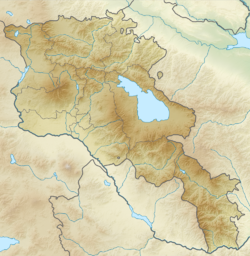
Getar ( Arm. Գետառ ) is a river in Armenia . It originates in the Kotayk region , flows through the central part of Yerevan and flows into Hrazdan . is located between the villages of and in the western part of the Geghama Mountains . The river flows through Avan-Arinj and connects with the Hrazdan River in Yerevan. Its length is about 24 kilometers. The left tributaries are Jrvezh [1] [2] and .
| Getar | |
|---|---|
| arm Գետառ | |
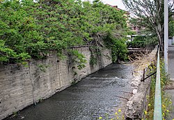 Channel in Yerevan Channel in Yerevan | |
| Characteristic | |
| Length | 24 km |
| Watercourse | |
| Source | |
| • Location | at the village of Mayakovsky |
| • Coordinates | |
| Mouth | Handed out |
| • Location | Yerevan , Shengavit district |
| • Coordinates | |
| Location | |
| A country |
|
| Regions | Kotayk region , Yerevan |
Content
General information
The Getar River area is very densely populated - 5021 inhabitants per square kilometer. The surrounding area is dominated by a cold climate. The average annual air temperature at the mouth is 14 ° С. The warmest month is July, when the average temperature is 30 ° C and the coldest is January, with −8 ° C. The average annual rainfall is 655 millimeters. The wettest month is May, with an average of 100 mm of rain, and the driest month is August, 18 mm [3] .
Bridge
In 1664, on the Getar River, not far from the old Nork district, opposite the entrance to the Yerevan Zoo , a 7 meters high was built. The design was developed by a certain architect named Grigor with the financial support of the Hovhannes Norksky vardapet . The bridge was of great importance because it served as the only way to cross the river and enter Yerevan from the north. It was one of the few structures in the area that survived the devastating earthquake in 1679 . Under Soviet rule in the 1950s, the bridge was repaired and came under state protection. It is well preserved today [4] [5] .
Mudflows
Mudflows often went along the Getar bed, the most noticeable of which occurred in 1860, 1866, 1873, 1912, 1923, 1924, 1946, 1947 and 1950.
The most recent serious mudflow occurred on May 25, 1946. The Seventh Stream caused great damage and destruction to the city. About 800 houses were destroyed, and another 630 were seriously damaged, about 200 people died. The disaster began at 8:30 pm and lasted five and a half hours. It affected the streets of Alaverdyan, Nalbandyan and Abovyan . After the flood, local residents were surprised to find stones 2 to 3 meters in diameter that settled on the streets [6] .
During the 1950s, a series of hydraulic works was implemented. Afforestation was carried out. A tunnel connecting Getar with the Hrazdan River was built to prevent future mudflows in Yerevan [7] .
Notes
- ↑ American Geographical Society of New York. Soviet geography (unknown) . - American Geographical Society, 1990. - T. 31 , No. 6-10 . - S. 578 .
- ↑ MI L'vovich. World water resources and their future. - Chelsa, Michigan: American Geophysical Union, 1979. - P. 229. - ISBN 9780875902241 .
- ↑ NASA Earth Observations: Population Density . NASA / SEDAC. Date of treatment January 30, 2016.
- ↑ Braginskiĭ, Vladimir. Tourist attractions in the USSR: a guide. - Moscow: Raduga Publishers, 1982. - P. 111.
- ↑ Կամուրջներ (Bridges) (in Armenian) (inaccessible link) . Yerevan City Municipality. Date of treatment January 1, 2013. Archived June 3, 2012.
- ↑ Yerevan - Garni - Geghard . Armenian Travel Bureau. Date of treatment February 15, 2013.
- ↑ Jones, J. Anthony A. Threats to global water security. - Dordrecht: Springer, 2009 .-- P. 221. - ISBN 9789048123445 .