Hallettsville is a city in the United States located in southeastern Texas , the administrative center of Lavaka County . According to the 2010 census, the number of inhabitants was 2550 people, according to the US Census Bureau in 2017, 2616 people lived in the city [3] .
| City | |
| Halletsville | |
|---|---|
| English Hallettsville | |
 | |
| A country | |
| State | Texas |
| County | Lavaka |
| History and Geography | |
| Founded | |
| Area | |
| Center height | |
| Timezone | UTC − 6 ; summer UTC − 5 |
| Population | |
| Population |
|
| Density | 359.2 people / km² |
| Digital identifiers | |
| Telephone code | +1 361 |
| Postcode | |
| FIPS | 48-31868 [1] |
| GNIS | |
Content
- 1 History
- 2 Geography
- 2.1 Climate
- 3 population
- 4 Local government
- 5 Infrastructure and transport
- 6 Education
- 7 Economics
- 8 Recreation and entertainment
- 9 City in popular culture
- 10 notes
- 11 Links
History
The settlement was named after the family of the first settlers, John and Margaret Hallett, who received a land grant from Stephen Austin in 1831. In 1836, after the death of her husband, Margaret donated land to the city. In 1842, Halletsville was chosen as the administrative center of LaBack County, but soon the district was disbanded. In 1846, after Texas joined the United States, Lavaka County was created and Halletsville became the administrative center of the new county. In 1849, a post office was opened in the city. In 1852, one of the district's first private schools, Alma Male and Female Institute , was opened in Halletsville, but it was closed during the Civil War . In 1860, the county began publishing the first newspaper, Hallettsville Lone Star . On August 13, 1870, the residents of Halletsville voted in favor of the city’s charter, but already in 1875 local government was abolished. The charter was re-adopted on June 29, 1888 [4] .
Many residents who settled in the region at the end of the 19th century came from Germany and the Czech Republic . In 1881, the Sacred Heart Academy School was opened, and in the late 1880s, public schools of the city opened. In 1887, the San Antonio and Aransas Pass Railway was built through the city, and Halletsville became an important commercial and transportation center for the region. By 1892, a power plant and a water supply system were operating in the city, working on water from artesian wells. The region’s economy is based on agriculture, farmers grow rice, corn, fruits and pecans , store hay, and raise cattle [4] .
Geography
Halletsville is located in the central part of the county, with coordinates: [5] .
According to the US Census Bureau , the area of the city is about 7.1 km 2 , fully occupied by land [5] .
Climate
According to the Köppen climate classification , a humid subtropical climate (Cfa) prevails in Halletsville [6] .
| Climate Halletsville | |||||||||||||
|---|---|---|---|---|---|---|---|---|---|---|---|---|---|
| Indicator | Jan | Feb | March | Apr | May | June | July | Aug | Sep | Oct | Nov | Dec | Year |
| Absolute maximum, ° C | 35 | 33.3 | 36.7 | 37,2 | 38.9 | 42.8 | 43.9 | 42.8 | 43.3 | 38.9 | 35.6 | 31.1 | 43.9 |
| Average maximum, ° C | 17.7 | 19,4 | 23.3 | 26.9 | 30,2 | 33,4 | 35,2 | 35.6 | 32.9 | 28.6 | 22.9 | 18.7 | 27.1 |
| Average temperature, ° C | 11.8 | 13.3 | 17,2 | 20.9 | 24.4 | 27.6 | 28.9 | 29.1 | 26.5 | 21.9 | 16.6 | 12.6 | 20.9 |
| Average minimum ° C | 5.8 | 7.3 | eleven | 14.9 | 18.7 | 21.7 | 22.7 | 22.6 | 20,2 | 15,2 | 10,2 | 6.5 | 14.7 |
| Absolute minimum, ° C | −14.4 | −15 | −7.8 | −1.7 | 3.3 | 11.1 | 13.3 | 12,2 | 5 | −6.7 | −8.3 | −15 | −15 |
| Precipitation rate, mm | 64 | 63 | 60 | 82 | 117 | 95 | 74 | 65 | 94 | 89 | 80 | 71 | 955 |
| Source: weatherbase.com [7] | |||||||||||||
Population
| Population census | |||
|---|---|---|---|
| Census year | Us. | % ± | |
| 1890 | 1011 | ||
| 1900 | 1457 | 44.1% | |
| 1910 | 1379 | -5.4% | |
| 1920 | 1444 | 4.7% | |
| 1930 | 1406 | -2.6% | |
| 1940 | 1581 | 12.4% | |
| 1950 | 2000 | 26.5% | |
| 1960 | 2808 | 40.4% | |
| 1970 | 2712 | -3.4% | |
| 1980 | 2865 | 5.6% | |
| 1990 | 2718 | -5.1% | |
| 2000 | 2345 | -13.7% | |
| 2010 | 2550 | 8.7% | |
| Current 2017 | 2616 | 2.6% | |
| 1890-2017 [8] [9] [3] | |||
According to the 2010 census, 2550 people lived in the city, there were 1020 households and 635 families. The racial makeup of the city: 75.7% are white , 17.6% are African Americans , 0.4% are Native Americans, 0.5% are Asians , 0.1% are residents of Hawaii or Oceania, 3.6% are others. races, 2.1% - two or more races. The number of Hispanic residents of any race was 15.9% [9] .
Out of 1020 households, children under 18 years of age live in 30.1%. 43.7% of households were couples living together (15.3% with children under 18 years of age), women lived without husbands in 15.3% of households, men lived without wives in 3.2% of households, 37.7% of households were not families. Only one person lived in 34.2% of households, 17.9% were single elderly people (over 65). The average household size was 2.3 people. The average family size is 2.95 people [9] .
The population of the city by age range was as follows: 26.1% are residents under 20 years old, 20.8% are between the ages of 20 and 39, 29.6% are between 40 and 64, 23.4% are 65 and older . The average age is 43.3 years [9] .
According to a five-year survey from 2012 to 2016, the median household income in Halletsville is $ 36,037 a year, and the median household income is $ 50,179. The per capita income for the city is $ 22,162. About 21.8% of families and 23.4% of the population are below the poverty line. Including 41.6% under the age of 18 years and 18.5% over 65 years of age [10] .
Local government
City management is carried out by the mayor and the city council consisting of 5 people. The city council appoints a deputy mayor from among its members [11] .
Infrastructure and transport
The main highways passing through Halletsville are:
- The US 77 motorway runs north from La Grange south to Victoria .
-
77 US alternative motorway starts at Halletsville and runs southwest towards Cuero . -
90 US alternative motorway runs east from Houston west to Gonzales .
The city is home to Halletsville Municipal Airport. The airport has one runway 978 meters long [12] . The closest airport for commercial flights is the Victoria Regional Airport. The airport is located about 75 kilometers south of Halletsville.
Education
The city is served by Halletsville Independent School District.
Economics
According to the financial report of the city for fiscal year 2016, Halletsville owned assets of $ 22.36 million, debt of the city amounted to $ 1.54 million. Incomes of the city amounted to $ 7.88 million, expenses of the city - $ 6.98 million [13] .
Recreation and Entertainment
Hallletsville hosts the Hall of Fame of the Texas Domino Championship, the Hall of Fame of Texas Violinists, and the Lavaka County Museum of History [14] .
Every year in January, a domino tournament is held in the city, in March - the Czech Kolache festival, in April - the Fiddlers Frolics violin festival, the county fair, and in September - the festival of sausages and polka [15] .
A city in popular culture
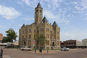
Despite the fact that real events took place near La Grange , the creators of the movie "The Best Brothel in Texas" used the picturesque central square of Halletsville to shoot cityscapes. In Halletsville, they also shot the horror movie of the same name with Gary Busey in the title role.
The city is also mentioned in Robert Keene’s song “Armadillo Jackel”, as a city in which two and a half dollars were paid for a dead battleship [16] .
Franchise Ripley's Believe It or Not! once called Halletsville a city of thirteen, because its English name is 13 letters, and in 1913 there were 1300 people living in the city, there were 13 churches, 13 newspapers and even 13 saloons [17] .
Notes
- ↑ 2017 Texas State Places Gazetteer File (TXT). Date of treatment July 2, 2018.
- ↑ 2016 US Gazetteer Files - U.S. Census Bureau , 2016.
- ↑ 1 2 Annual Estimates of the Resident Population: April 1, 2010 to July 1, 2017 (Hallettsville city, Texas ) . US Census Bureau. Date of treatment July 2, 2018.
- ↑ 1 2 Mary Ramsey. Hallettsville, TX (English) (HTML). Handbook of Texas Online . Texas State Historical Association. Date of treatment July 2, 2018.
- ↑ 1 2 Geographic Identifiers: 2010 Demographic Profile Data (G001): Hallettsville city, Texas . American Factfinder . US Census Bureau. Date of treatment July 2, 2018.
- ↑ Hallettsville, Texas Climate Summary . Date of treatment July 2, 2018.
- ↑ Hallettsville, Texas. Weather Averages Summary weatherbase.com Date of treatment July 2, 2018.
- ↑ Texas Almanac: City Population History from 1850–2000 (English) (PDF). Texas Almanac. Date of treatment July 2, 2018.
- ↑ 1 2 3 4 Census 2010: General Population and Housing Characteristics, Hallettsville city, TX . US Census Bureau. Date of treatment July 2, 2018.
- ↑ 2012-2016 American Community Survey 5-Year Estimates. Hallettsville city, TX . US Census Bureau. Date of treatment July 2, 2018.
- ↑ City Council. City of Hallettsville, TX . Date of treatment July 2, 2018.
- ↑ 34R - Hallettsville Municipal Airport . Date of treatment July 2, 2018.
- ↑ CITY OF HALLETTSVILLE, TEXAS ANNUAL FINANCIAL REPORT For the Fiscal Year Ended DECEMBER 31, 2016 (English) (PDF). Date of treatment July 2, 2018.
- ↑ Hallettsville activities . Date of treatment July 2, 2018.
- ↑ Hallettsville Coming Events ( inaccessible link - history ) . Hallettsville Chamber of Commerce. Date of treatment July 2, 2018.
- ↑ The Armadillo Jackal Lyrics . Metro Lyrics. Date of treatment July 2, 2018.
- ↑ Hallettsville . lone-star.net. Date of treatment July 2, 2018.
Links
- Halletsville Official Website .
- Halletsville Chamber of Commerce .
- Information about the city of Halletsville (English) (HTML). Handbook of Texas Online . Texas State Historical Association.
- Information about Halletsville at texasescapes.com .
- Halletsville Independent School District .