Zywieckie Lake , Zywieckie [1] ( Polish. Jezioro Żywieckie ) [2] , also known as Zywiecki Reservoir ( Polish. Żywiecki Zbiornik Wodny ) or Tresna Reservoir ( Polish. Zbiornik Wodny Tresna ) is a Polish reservoir (located on an artificial lake) the Sol river near Zywiec , on the border of the Zywieck Depression and the Small Beskydy mountain range. It was founded in 1966 by flooding several villages: Zazhece, Tresna, Zadzele and Stary Zywiec.
| Zywieckie Lake | |
|---|---|
| polish Jezioro Żywieckie | |
 | |
| Morphometry | |
| Height above sea level | 39 m |
| Dimensions | 6.6 × 3.1 km |
| Square | 10 km² |
| Volume | 0.0946 km³ |
| Coastline | 33.7 km |
| Deepest | 26.8 m |
| Average depth | 8.6 m |
| Specifications | |
| Year of filling | 1966 |
| Pool | |
| Flowing stream | Sola |
| Flowing stream | Sola |
| Location | |
| A country |
|
| Province | Silesian Voivodeship |

Geographical position
The main morphometric parameters of the Zyvets reservoir are as follows [3] :
- Total volume - 94.6 million m³
- Dead volume of the formation - 3.2 million m³
- Constant flood volume - 23.1 million m³
- Compensation volume - 67.7 million m³
- The maximum level of dams is 344.86 m above sea level
- The normal dam level is 342.56 m above sea level
- The minimum dam level is 320.94 m above sea level
At a normal level of dams, the parameters of the Zyvets reservoir are as follows [3] :
- Maximum length - 6.6 km
- Average length - 6.25 km
- The coastline is 33.7 km
- Maximum width - 3.1 km
- Width in the central part - 2.5 km
- Average width - 1.51 km
- Maximum depth - 26.8 km
- Average depth - 8.6 km
Zywiecki reservoir appeared due to the construction of a dam on the Sola River. Its length is 310 m, height 39 m above sea level, built 41.9 km from the river (the Soly catchment area along the profile in Tresny is 1036.6 km²) [3] .
Use
The dam is part of a 21 MW hydroelectric power station. Currently, the reservoir is used not only for electricity generation, flood protection and regulation of tributaries of the Upper Vistula, but also for tourism purposes. The reservoir is systematically filled with sludge using river pumps, and the material that comes from the shore abrasive. It is assumed that within 70 years from the date of construction, the volume will decrease by about 50% [4] . In 2015, due to drought, the water level decreased by 2 meters, which made it possible to better see and explore the bottom [5] .
Known Events
- Every year in August, a regatta is held on the lake in memory of Adam Banashek.
- On November 15, 1978, a occurred near a lake. At 5 o’clock in the morning, two Autosan H9 and Autosan H09 buses, which drove the miners to the Bzhesche coal mine, fell off and fell into the waters of Lake Zywiecki from an altitude of 18 m. 30 people died, 9 were miraculously saved. A memorial plaque on the bridge reminds of the tragedy.
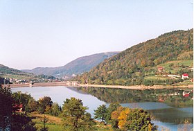
Gallery
View of the lake from the peak of Šksičně
View of the lake from the peak of Zhar
Ywieckie Lake and Škšičně Mountain
Notes
- ↑ Topographic maps of the General Staff
- ↑ Nazwa (Polish)
- ↑ 1 2 3 Machowski et al., 2005 , s. 80
- ↑ Chełmicki Wojciech: Blaski i cienie zapór wodnych , w: “Poznaj Świat” R. XXXIV, nr 2 (397), luty 1986, s. 3-6.
- ↑ Jezioro Żywieckie przez suszę jest wyschnięte jak kałuża (Polish)
Literature
- Robert Machowski, Martyna A. Rzętała, Mariusz Rzętała, Beata Wistuba. Zbiornik Żywiecki - charakterystyka fizycznogeograficzna i znaczenie społeczno-gospodarcze. - Sosnowiec: Polskie Towarzystwo Geograficzne - Oddział Katowicki, 2005 .-- ISBN 83-922610-0-3 .