Bolshoy Solyony ( Ukr. The Great Soloniy estuary ) - estuary on the Murza bow in the Danube River Delta, located in the east of the Kiliysky District ( Odessa Region ). Water mirror area - n / a km². The type of general mineralization is brackish . Origin -. The hydrological regime group is waste .
| Big Salty | |
|---|---|
| Ukrainian The Great Solonius Estuary | |
 Stensovskie floodplains | |
| Characteristics | |
| Bay Type | estuary |
| Flowing river | Burova Kishla |
| Location | |
| A country |
|
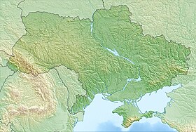
| Region | Odessa region |
| Area | Kiliysky district |

Content
- 1 Geography
- 2 Economic value
- 3 notes
- 4 Sources and links
Geography
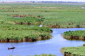
The length is about 2.0 km. The average width is km, the largest is about 0.5 km. The average depth is m, the greatest is m. Altitude: -0.4 m. The nearest settlement is the village of Desantnoye , located north of the estuary.
The Great Salt Estuary is located in the Danube Delta on the territory of the Stensovskii (Stensovsko-Zhebriyansky) floodplains , which are separated from the Black Sea and the Danube-Sasik Canal. Pond of irregular elongated shape, stretched from north to south. The estuaries Bolshoy Solyony , Maliy Solyony and Firefighter form a single water complex on the Murza Str . At the confluence of the Burova Kishla beam. The complex of estuaries is limited by hydraulic structures (dams, including the dam of the Danube-Sasik canal). The banks are steep and represented by abundant coastal-aquatic vegetation, except for the northwest - acacia thickets. In the north, at the confluence of the Burov Kishla beam into the estuary, the T-16-28 highway passes.
Economic Significance
Further south is the Danube Biosphere Reserve .
It is a nesting site for aquatic and near-water birds. Due to anthropogenic influence (the construction of the Danube – Sasik canal), the natural complex and water bodies are highly degraded.
Notes
Sources and links
- Map sheet L-35-96 Vilkovo . Scale: 1: 100 000. Indicate the date of issue / condition of the area .