Lére [2] [3] ( fr. Lac de Léré ) is a flowing lake located in the west of the department in the West Mayo-Kebi region , at the border with Cameroon in southwestern Chad , 290 km from the capital countries [4] . Lake Lere has a latitudinal shape. At low water, the water edge is located at an altitude of about 234 meters above sea level , at which the lake covers an area of 41 km² [5] . The River flows through the lake, which also connects Leray with the smaller Lake Trené , located northeast; during the rise of the water level in the flood, both lakes merge, forming a vast reservoir stretching along the Mayo-Kebi channel for tens of kilometers [5] [1] [4] . In the vicinity, wild vegetation grows and agricultural land is located [6] .
| Lake | |
| Lera | |
|---|---|
| fr. Lac de léré | |
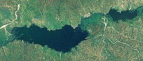 Snapshot of Lere and Tren Lakes from NASA World Wind | |
| Morphometry | |
| Absolute height | 231 [1] –239 [2] m |
| Dimensions | 14.5 × 4 [K 1] km |
| Area | 41 [To 1] km² |
| Deepest | 8 [K 1] m |
| Average depth | 4.5 [K 1] m |
| Swimming pool | |
| Flowing river | Mayo kebby |
| Flowing river | Mayo kebby |
| Location | |
| A country |
|
| Region | Western Mayo Kebi |
| Area | Lac Leray |

Since 1974, part of the eastern half of the water area of Lake Lere and the surrounding area has been under state protection, being part of the Binder-Lere faunal reserve [7] , which in 2005 was included in the Ramsar Convention [8] .
The average annual temperature in this area is 26 ° С, while the temperature reaches its highest point in April, and the lowest in July [9] . The annual rainfall is 989 mm. [10]
Comments
- ↑ 1 2 3 4 5 at low water [5] .
Notes
- ↑ 1 2 Map sheet C-33-XXI . Scale: 1: 200,000 .
- ↑ 1 2 Chad: Reference map: Scale 1: 2 500 000 . - M .: GUGK, 1982.
- ↑ Lere // Dictionary of geographical names of foreign countries / ed. ed. A.M. Komkov . - 3rd ed., Revised. and add. - M .: Nedra , 1986. - S. 195.
- ↑ 1 2 Data obtained using the Google Maps mapping service.
- ↑ 1 2 3 RH Hughes. The Lere lakes // A Directory of African Wetlands. - IUCN, 1992. - S. 335. - ISBN 2880329493 , 9782880329495.
- ↑ NASA Earth Observations: Land Cover Classification . NASA / MODIS. Date of contact 30 Enero 2016.
- ↑ Binder-Léré in Chad . - Information about the protected natural area on the protectedplanet.net website.
- ↑ Réserve de faune de Binder-Léré (English) . - Information on wetlands on the official website of the Ramsar Convention : ramsar.org (English) (Spanish) (French) .
- ↑ NASA Earth Observations Data Set Index . NASA Date of contact 30 Enero 2016.
- ↑ NASA Earth Observations: Rainfall (1 month - TRMM) . NASA / Tropical Rainfall Monitoring Mission. Date of contact 30 Enero 2016.