Gray [1] - also called Gray Lake, is a reservoir of glacial origin, located in the western part of the Torres del Paine National Park , in the province of Ultima Esperanza , the Magallanes region and in the Chilean Antarctic , Chile . [2]
| Lake | |
| Gray | |
|---|---|
| isp. Lago gray | |
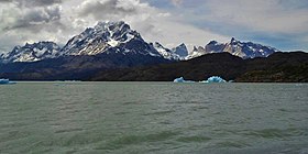 Lake view in December 2013 | |
| Pool | |
| Flowing river | Gray |
| Location | |
| A country |
|
| Region | Magallanes |
| Provinces | Ultima Esperanza |

Characteristics

This lake has an area of 3250 hectares, a length of 16.5 km, a maximum width of 4.25 km and a minimum width of 1.37 km. It belongs to the large basin of Rio Serrano. Within the lake there are a peninsula and several bays. Its waters are turbid due to sediment from the glacier. The name of the lake comes from the color of its water - gray, the lake is remarkable by the fact that in its waters flocks of ice of blue color float.
In the east, the lake borders the Paine Grande Mountains with a height of 2,700 meters (8,858 feet) and the hill of Aleta de Tiburon. To the south is bordered by the hill Ferreira with a height of 1599 m.
Islands
There are several islands in the southern part of the lake; the largest of them, 600 meters long. There are also islands in the far north, but they are all edged with the Gray glacier, because a few years ago they were just nunataks of this glacier. The largest of them is 3.6 km long and 2 km wide.
Sources
Gray Lake comes from the huge Gray Glacier, which is located in the northern part of the lake. This is a mass of ice 6 kilometers wide and more than 30 meters high, divided into two fronts. In 1996, it had a total area of 270 km² and a length of 28 km. This glacier is part of the South Patagonian glacial plateau . [3] Not far from the southern part of the lake is the source of the Pingo River, which dumps its waters into the Pingo Lake, fed by the Pingo Glacier and the Zapata Glacier.
Drainage
From the waters of the lake the Gray River feeds, this river having passed about 20 km, flows into Rio Serrano.
Notes
- ↑ Map sheet M-18-G (Yu. P.) . Scale: 1: 500,000 .
- ↑ (en español) Cuenca del río Serrano. (inaccessible link) . Archived June 7, 2007.
- ↑ Gray Glacier - Chile .