DORIS ( French Détermination d'Orbite et Radiopositionnement Intégré par Satellite , abbreviated DORIS ) - French civil system for accurate (centimeter) orbit determination and positioning. The operation is based on the principle of the Doppler effect [1] . It includes a system of stationary ground-based transmitters - beacons , receivers are located on satellites. After determining the exact position of the satellite, the system can establish the exact coordinates and height of the beacon on the Earth's surface. Originally intended to solve the problems of geodesy and geophysics .
Content
General information
The DORIS system was developed and optimized by CNES , IGN (Institut Géographique National) and GRGS (Groupe de Recherches en Géodésie Spatiale) for highly accurate orbit and positioning of beacons. DORIS was originally developed as part of the TOPEX / POSEIDON oceanographic altimetry mission. DORIS has been in operation since 1990, when the first technological demonstration system (payload prototype) was launched on board the SPOT-2 spacecraft. DORIS is a microwave tracking system, an uplink radio system based on the Doppler principle , which requires a satellite host (for a space segment packet) and a global network of ground-based tracking stations. The main goal is to provide accurate measurements for POD (Precise Orbit Determination) services and surveying applications. The concept of the system is based on accurate measurements of Doppler shifts on an RF signal transmitted by ground stations and received on board orbiting satellites carrying DORIS receivers when they are in station visibility. The number of DORIS satellite carriers is unlimited. The measurement results provided by DORIS receivers can be used in the following applications:
- POD support for altimetry and other missions;
- orbit control (on board or on Earth);
- ground beacon positioning;
- geophysical modeling (Earth's gravitational field , atmosphere , ionosphere , monitoring the movement of the poles of the Earth , etc.);
- DORIS system integrity control.
The DORIS system is based on the accurate measurement of the Doppler shift of the radio frequency of signals transmitted by ground beacons and received on board the spacecraft. The measurements are performed at two frequencies: 2.03625 GHz - for measuring the Doppler shift and 401.25 MHz - for correcting the propagation delay of the signal in the ionosphere. A frequency of 401.25 MHz is also used for time stamps of measurements and transmission of auxiliary data. Choosing a satellite-only transmission system allows you to fully automate the operations of beacons and communication lines for the centralized delivery of data to a processing center.
Doppler frequency shift is measured on board the satellite every 10 seconds. The obtained radial velocity (its accuracy is approximately 0.4 mm / s) is used on Earth in combination with a dynamic model of the satellite trajectory to accurately determine the orbit with a height error of not more than 5 cm. These data become available after 1.5 months due to delays in external data, such as solar radiation .
DORIS Satellite Mission Overview
| Mission | Launch date | Presented Services |
|---|---|---|
| SPOT-2 (CNES) | January 22, 1990 | Introduction of the 1st generation receiver (18 kg), dual-frequency system in 1 channel |
| TOPEX / Poseidon | August 10, 1992 | |
| SPOT-3 ( CNES ) | September 26, 1993 | |
| SPOT-4 ( CNES ) | March 24, 1998 | Implementation of an experimental DIODE software package that provides real-time processing capabilities for S / C navigation |
| Envisat ( CNES ) | March 1, 2002 | - launch of the second generation receiver (11 kg), dual-frequency system in 2 channels; - improved version of DIODE with the gravitational model of the Earth and the attraction of the sun / moon. |
| Jason-1 ( NASA / CNES ) | December 7, 2001 | Introduction of a miniature receiver of the 2nd generation (5.6 kg), a dual-frequency system in 2 channels |
| SPOT-5 ( CNES ) | May 04, 2002 | Second Generation Miniature Receiver |
| CryoSat ( ESA ) | October 08, 2005 S / C Launch Error | - DIODE added another feature: inertial J2000 on-board location and speed data to be used by AOCS; - introduction of a new processor: Sparc ERS 32 |
| Jason-2 ( NASA / CNES , NOAA, EUMETSAT) | June 20, 2008 | - DGxx receivers: 8 channels based on DIODE directives for receiving beacon signals; - DIODE added the function: "Surveying Bulletins", giving a height above the reference geoid Jason-2 , AltiKa, etc. |
| CryoSat-2 ( ESA ) | April 8, 2010 | - real-time orbit detection for determining the spacecraft and controlling the orbit (onboard); - providing an accurate time reference based on TAI ( International Atomic Time ); In addition, an accurate 10 MHz reference signal (on-board) is used; - providing ground-based POD (determination of the exact orbit) and ionospheric modeling |
| HY-2 (Haiyang-2), ( CNSA ) | August 15, 2011 | |
| Pléiades ( CNES ) two spacecraft | December 17, 2011 2013 | - HR1: Orbit determination is performed by the DORIS receiver; - HR2: orbit detection performed by the DORIS receiver |
| SARAL [2] ( ISRO / CNES ) with AltiKa | February 25, 2013 | |
| Sentinel-3 A (GMES), ESA | February 2, 2016 [3] [4] | |
| Jason-3 ( Eumetsat , NOAA , CNES ) | Jan. 17, 2016 |
DORIS Orbit Definition Overview
| Parameter | 1st generation | 2nd generation | 2nd generation (small-sized devices) |
|---|---|---|---|
| Missions | SPOT-2, −3, TOPEX / Poseidon, SPOT-4 | Envisat | Jason-1, Spot-5 |
| Orbit accuracy | ≤3 cm in radius | cm radius | ≤3 cm in radius |
| Real-time orbit detection | 5m / 3 axis axis (SPOT 4) | Axis on 1 m / 3 axis | 30 cm in radius, others at 1 m |
| Time accuracy | 3 μs | 3 μs | 3 μs |
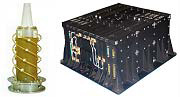
DORIS Toolkit
The DORIS onboard tool consists of
- additional receiver with two receiving circuits;
- ultra-stable crystal oscillator (Ultra Stable Oscillator - USO) with a frequency change of no more than identical to the generators used in the DORIS ground segment;
- omnidirectional dual frequency antenna;
- control unit device (combined with MWR).
Ground segment consists of
- SSALTO multimission control center managed by CLS on behalf of CNES ;
- lighthouse installations and a control center from IGN , the coordinating global network of beacon for determining orbits (ODB). The network consists of 60 tracking stations located around the globe in 30 countries (in Russia: Krasnoyarsk , Badary tract (Tunkinsky district, the Republic of Buryatia) , Yuzhno-Sakhalinsk , Paramushir [5] );
- Accurate orbits performed by CNES and Earth's gravitational field calculations from DORIS with GRGS ; the time scale and the reference frequency for the entire system is provided by the main beacon associated with the main clock; the control center of the DORIS system performs instrument control according to telemetry data and operational determination of orbits.
DORIS DGxx instrument specifications
| one | 2 |
|---|---|
| High precision Doppler measurements and on-board navigation | - provides elementary speed measurements with an accuracy of no worse than 0.3 mm / s; - provides real-time PVT information in the ITRF and J2000 reference systems with centimeter accuracy depending on the characteristics of the orbit and the spacecraft; - the ability to provide surveying data for altimeter tracking |
| Beacon Tracking Ability | Up to 7 beacons at a time (7 dual-frequency channels) |
| Work autonomy | - Routine high-precision navigation mode; - prediction of maneuver |
| Power supply | 22-37 V DC, 23 W; 30 W when warming up, less than 2 hours |
| Telemetry / Telecontrol Interface | - MIL-STD-1553 / CCSDS terminal packet protocol; - maximum speed Kbps - two two-level states per chain (power and software status) |
| CPU / software | - radiation-resistant design with the ability to detect processor failures and memory failures SPARC ERC32 with recovery; - double “hot” backup of all software in two redundant EEPROM banks; can be fully loaded without interruption of operation; |
| Weight, power, size | 16 kg, 24 W, 390 mm x 370 mm x 165 mm. For redundant DGxx configuration (next generation), including two USOs that are now placed inside the receiver |
DORIS Beam Positioning Efficiency
| Duration of data collection | Accuracy (1 satellite) | Accuracy (2 satellites) |
|---|---|---|
| 1 hour | 1m | 50 cm |
| 1 day | 20 cm | 15 cm |
| 5 days | 10 cm | 7 cm |
| 26 days | 3 cm | 1-2 cm |
Notes
- ↑ One of the first applications of the Doppler effect for satellite navigation was in the Transit system, which was used to navigate American nuclear missiles of the George Washington class and provide navigation support for launching Polaris ballistic missiles from these boats. However, unlike DORIS, the signal frequency was measured in the ground (user) segment
- ↑ SARAL / AltiKa Products Handbook
- ↑ News: Sentinel-3A satellite successfully launched into target orbit
- ↑ Launch of the Rokot launch vehicle with the Sentinel-3A spacecraft
- ↑ List of DORIS stations on the official website
Literature
- P.FERRAGE, A.AURIOL, C. TOURAIN, C. JAYLES, F. BOLDO. Doris system developments and future missions Slides: Development of the DORIS System and Future Missions
- Lebedev S. A. Satellite altimetry in Earth sciences / Modern problems of remote sensing of the Earth from space. 2013.V. 10. No. 3. P. 33-49.
- Deev M.G. Level as an indicator of changes in the state of the World Ocean / Geography. Number 6. 2010
- Lebedev S. A. Integrated Satellite Altimetry Database (Slides)