Valley networks are branched channel systems with a width of hundreds of meters to 20 km and a depth of hundreds of meters, spread on the surface of Mars . Detailed images and maps were obtained starting from the pictures taken as part of the Viking program [1] .
Unlike outflow channels , small tributaries in the networks of valleys are located at a higher elevation, merging into larger ones. Their structure, however, is not as complex as that of river systems on Earth; most have a width of no more than a few kilometers. The majority (92%; 759 of 827) of the valley networks are located on the surface, the age of which belongs to the Noah period , that is, they formed in the era of the late heavy bombardment . About 4% (34) are in the Hesperian regions and the remaining 4% may be even younger [2] .
The presence in the Noah regions of branched channel networks resembling terrestrial river systems, as well as the presence of other relief elements indicating erosion and sedimentation processes ( deltas , drift cones , lake beds), suggests that it was water that also caused erosion during the formation of networks the valleys climate on Mars was warm and humid enough for the existence of rivers. However, the features of most of the networks of valleys (steep slopes, sharp boundaries) make them more likely to be elements of the earth's relief associated with , when the surface of the soil falls, eroded from below by horizontal subsurface water flows [2] . A number of scientists adhere to the theory that networks of valleys are exclusively of such a nature [3] . Generally speaking, this does not require a warm and humid climate; nevertheless, it still indicates the presence of water in a liquid state [4] . In addition, recent studies confirm precisely the model of the warm and humid Noah period [5] .
Nergal Valley , a snapshot of the Mariner-9 apparatus.

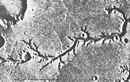
An extensive network of valleys in the , a snapshot of the Viking apparatus . You can see the characteristic sharp boundaries of the channels.

in the quadrangle of Tavmasia, image of the THEMIS satellite. A large number of sources of water flowing through numerous tributaries of the water, which is typical for the river system, indicates not just liquid water, but precipitation.

The network of valleys in in the region of the equator of the planet is quite bright due to the high reflectivity of sand deposits on the surface. You can see many impact craters.

satellite image

.
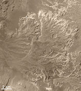
Delta in the Eberswalde Crater , shot of a MOC camera .


Formation Mechanism
The generally recognized fact is that for the formation of networks of valleys, it was necessary to influence the liquid, and most likely water [1] . However, experts disagree on how this water appeared on the surface of the planet and how long and how often it was there. Various options are possible:
- Rainfall
- Precipitation in the form of snow, the lower layer of which melted under the influence of heating from below
- Groundwater coming to the surface and forming currents flowing through it
The early surface images obtained by the Mariner and Viking devices demonstrate the specific features of the channels: the tributaries are short and wide, as if cut off, have a U-shaped cross section, and there are few of them [1] . It is these forms that are formed as a result of , which can be observed, for example, on Earth in the area of the in Utah, USA , or in the Apalachicola River Valley in Florida [6] . In case of precipitation (rain), the water flows over the entire solid surface, and the entire area is cut up by numerous channels forming a dense network of tributaries, starting with the smallest on the tops and ridges of the mountains [1] .
However, subsequently, with the help of tools such as THEMIS and HiRISE , images of better quality and higher resolution were obtained, according to which detailed maps of the surface of Mars were compiled [7] . And on these maps, with an increase in resolution (although to a certain limit), you can also see small tributaries forming branched network of channels, characteristic of river valleys in areas where it rains systematically. All networks of valleys for which such a branched structure is clearly visible in high resolution (for example, ) relate in time (judging by comparison with the number of craters) to a rather narrow range at the end of the Noah - beginning of the Hesperium periods - 3.6 -3.8 billion years ago, that is, after the late heavy bombardment. Consequently, precipitation, which caused their formation, was not caused by one or another change in the composition of the atmosphere due to the fall of meteorites. And finally, some networks of valleys located on a younger (Hesperian or even Amazonian ) surface, such as the Nergal and , are definitely formed precisely by groundwater flooding [1] . This suggests that in the early Hesperian period there was a certain transitional moment from the formation of network of valleys due to precipitation to the growth of canyons only due to groundwater, that is, precipitation stopped and the climate became dry and cold [4] .
See also
- Hydrosphere of Mars
- Mars Climate
Notes
- ↑ 1 2 3 4 5 Emily Lakdawalla. Mars' valley networks tell us of a dry, then wet, then dry Mars // The Planetary Society. - 2013. - September 10.
- ↑ 1 2 Water on Mars now or in the past? (eng.) . Vanderbilt University (2001). Date of treatment July 9, 2017.
- ↑ Virginia C Gulick. Origin of the valley networks on Mars: a hydrological perspective: [ eng. ] // Geomorphology. - 2001. - T. 37, no. 3-4 (April 20). - S. 241-268. - DOI : 10.1016 / S0169-555X (00) 00086-6 .
- ↑ 1 2 Michael H. Carr. The fluvial history of Mars : [ eng. ] // Philosophical Transactions of the Royal Society A. - 2012. - T. 370 (2 April). - S. 2193-2215. - DOI : 10.1098 / rsta.2011.0500 .
- ↑ Wei Luo, Xuezhi Cang & Alan D. Howard. New Martian valley network volume estimate consistent with ancient ocean and warm and wet climate : [ eng. ] // Nature Communications. - 2017. - T. 8, No. 15766 (2017) (5 July). - ISSN 2041-1723 . - DOI : 10.1038 / ncomms15766 .
- ↑ J. Taylor Perron and Jennifer L. Hamon. Equilibrium form of horizontally retreating, soil-mantled hillslopes: Model development and application to a groundwater sapping landscape: [ eng. ] // J. Geophys. Res. - 2012 .-- T. 117 (March 20). - S. F01027. - DOI : 10.1029 / 2011JF002139 .
- ↑ Brian M. Hynek, Michael Beach, and Monica RT Hoke. Updated global map of Martian valley networks and implications for climate and hydrologic processes : [ eng. ] // J. Geophys. Res .. - 2010 .-- T. 115 (September 22). - S. E09008. - DOI : 10.1029 / 2009JE003548 .