Kabompo (in the upper reaches of the Big Kabompo ; English Kabompo ) is a river flowing in the North-Western province of Zambia and is one of the main tributaries of the Zambezi River in its upper reaches. The length of Cabompo is 410 km; the average water flow rate is 210 m³ / s [1] .
| Cabompo | |
|---|---|
| English Kabompo | |
| Characteristic | |
| Length | 410 km |
| Pool | 72,000 km² |
| Water consumption | 210 m³ / s |
| Watercourse | |
| Mouth | Zambezi |
| • Location | near Lukulu , Zambia |
| • Coordinates | |
| Location | |
| Water system | Zambezi → Indian Ocean |
| A country |
|
| Region | North West Province |
River
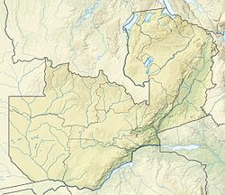
Cabompo begins its journey on the border of Zambia and DR Congo with the hills that form the eastern watershed between the river systems of Zambezi and Congo . It flows southwest through the savannahs of miombo , further along the West Lunga National Park . Downstream, after the city of Cabompo , the river forms a marshy floodplain up to 5 km wide. The mouth is located just north of the city of Lukuku .
The largest tributaries of the Cabompo are the rivers West Lunga (right tributary) and Dongwe (left tributary).
Nutrition
The river feeds mainly in the rain - during the rainy season (from November to April), it spills heavily, in the dry season (from May to October) it becomes smaller. The average annual rainfall in the Cabompo basin ranges from 900 mm in the south to 1400 mm in the north [1] .
Notes
- ↑ 1 2 Mwiza Muzumara. Application of remote sensing using a GIS based soil water assesment tool (SWAT) to estimate river discharge in the Kabompo River basin, Zambia . University of Zambia, IWRM Center. School of Mines (July 2011). Date of treatment July 7, 2017.