Des [1] , the outdated name is Diz [2] [3] ( Pers. دز , modern pronunciation: Daz; and until the 1920s, Diz) - a river flowing in the west of Iran . The river covers the territories of the provinces of Lurestan and Khuzestan , originates in the Zagros mountains [4] , flows into such large rivers as Karun and Arvand-Rud. The river is 515 km long [5] .
| Des | |
|---|---|
| Persian. دز | |
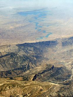 Aerial view of the Diz reservoir Aerial view of the Diz reservoir | |
| Characteristic | |
| Length | 515 km |
| Water consumption | 140 m³ / s |
| Watercourse | |
| Mouth | Karun |
| • Coordinates | |
| Location | |
| Water system | Karun → Shatt al-Arab → Persian Gulf |
| A country |
|
| Regions | Lurestan , Khuzestan |


Name Origin
It is believed that the name "Diz" comes from the word "castle, fortress." Also, this river had the Greek name "Κοπράτης" (transliteration - Kopratis).
River Characteristics
Water Consumption
Minimum: 140 m³ / s; maximum: 4337 m³ / s
Tributaries
Rud-e-Marbore, Tenge-Holeven , Bakhtiyari, Ab-e-Rudbar, Bala Rud.
Hydrology and Ecology
The Diz River is formed from the confluence of two branches, Cesar and Bakhtiyari, flows into the largest river of Iran, Karun, which flows in the south-west of the country.
The areas adjacent to the Diz River belong to the protected nature reserve. The river is surrounded by tropical and subtropical forests on the banks. The Diz district, named after the river, is divided into two zones: a reserve and a wildlife reserve. The total area of the protected area is 16 thousand hectares.
Des Dam
In 1963, Iran opened the largest dam in the country called Des. The dam is located on the Diz River, 25 kilometers from the city of Dizful in Khuzestan. The reservoir capacity is 3350 million cubic meters.
The height of the dam is 203 meters, it is considered the highest in the Middle East, according to world indicators, it takes 6th place.
The dam was built by the Italian company Salini Impregilo. This company built dams in Zambia on the Zambezi River (126 meters), in Pakistan on the Indus River (143 meters), in Ghana on the Volta River. The oldest hydropower plant in the region is located on the Diz River.
Before the 1979 Islamic Revolution in Iran, most of the irrigated land near the dam was managed by foreign corporations, including Mitsui, Chase Manhattan, Shell, John Deere, and Transworld.
Notes
- ↑ Western Iran // Atlas of the World / comp. and preparation. to the ed. PKO "Cartography" in 2002; ch. ed. V.P. Seleznev ; open Ed .: T.G. Novikova , T.M. Vorobyova . - 3rd ed., Eras., Fr. Atlas of National Highways Company CJSC in 2008 with a range. Roskartografii. - M .: PKO "Cartography": Harvest, 2008. - S. 165. - ISBN 978-5-17-047018-1 (Cartography). - ISBN 978-985-16-6027-4 (Harvest).
- ↑ Map sheet I-39-XXV .
- ↑ Iran: Reference card / comp. and preparation. to print PKO "Cartography" in 1985; ed. Z. P. Pekhov, T.I. Tyapko. - 4th ed. - 1: 2 500 000, 25 km per 1 cm. - M .: GUGK, 1986.
- ↑ رودخانه دز و پارکهای ساحلی رودخانه | جاهای دیدنی ایران
- ↑ رود خانه های خوزستان