Leskov Island ( eng. Leskov Island ) is a small uninhabited island in the South Sandwich Islands archipelago in the southern Atlantic Ocean . They are part of the overseas territory of Great Britain South Georgia and the South Sandwich Islands (that is, they belong to Great Britain, but are not part of it).
| Leskov Island | |
|---|---|
| English Leskov Island | |
 | |
| Specifications | |
| Square | 0.3 km² |
| Highest point | 190 m |
| Population | 0 people (2012) |
| Location | |
| Archipelago | South Sandwich Islands |
| Water area | Atlantic Ocean |
| A country |
|

Geography

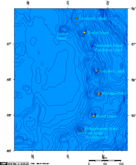
Leskova Island is located 520 km south-east of the main island of South Georgia and north-east of Antarctica and is part of the South Sandwich Islands . Together with the neighboring islands of High and Zavadovsky forms the Traversay archipelago .
The area of Leskov Island is about 0.3 km², and it is of volcanic origin. It differs from the rest of the South Sandwich Islands by two features. First, Leskov Island is located outside the chain, which form the neighboring islands. Secondly, its soil is mainly not basalt , as in other islands, but more than half andesite .
History
The island was discovered in 1819 by the first Russian Antarctic expedition of Faddey Faddeevich Bellingshausen and Mikhail Petrovich Lazarev and was named after Lieutenant Arkady Leskov , the third officer of the sloop Vostok .
December 22 (1819). The wind was strong and set off great excitement; the moon shone; the thermometer stood below the freezing point of 0.1 °; at night, we met ice in huge blocks, on the rumba ON and SWS; in the morning it was snowing. When it was dawn, we descended to OS, but for no more than an hour we went by this course; thick cloudiness led the sloops to the wind. At 8 o'clock in the morning, the cloudiness somewhat decreased, and we formed the ONO; time it was snowing and hiding everything that without obstacles from the snow could be seen; at 11 o'clock, when it was somewhat cleared, an unknown island opened to the north thirteen miles north; we turned to it, adding sails, trying to keep closer as much as the wind allowed; they wanted to determine the position of the island, this gloom was hindered. At the beginning of the first hour of the afternoon the sun peeped out from behind the clouds for a short time, and the astronomer Simonov managed to take it up, by means of which we determined the latitude of our place at midday 56 ° 43 south, the longitude was 28 ° 7 west; at the same time, we saw the island on NW 24 °, at a distance of five miles, which determines its latitude 56 ° 41 30 ", longitude 28 ° 10; according to the observation of Lieutenant Lazarev, latitude 56 ° 41, longitude 28 ° 7 40". The island has the form of a mountain ridge, protruding from the ocean, lies NW and SO 37 °, a few less than two miles long, half as long; the southern part ends in a small, sugar-like head, an elevation that seems separate from afar; the whole island is covered with snow and ice, was not yet known, and therefore I called the island Leskov, in honor of the third lieutenant of the sloop "Vostok"
- Bellingshausen, Faddey Faddeevich. Double explorations in the Arctic Ocean and sailing around the world in the course of 1819, 1820 and 1821.
Links
- Kurzbeschreibung mit Karte (English)
- ↑ Challenged by Argentina as part of the province of Tierra del Fuego, Antarctica and the islands of the South Atlantic .