Bely Nil [1] ( arab. النيل الأبيض ; transliteration: an-Nyl al-Abyad ) is one of 18 provinces [1] of Sudan , borders South Sudan in the south.
- The territory is 30 411 km² .
- The population of 1,730,588 people (for 2008 ).
| provinces | |
| White Nile | |
|---|---|
| Arab. النيل الأبيض | |
| A country | Sudan |
| Includes | 4 districts ( districts ) |
| Adm Centre | Rabac |
| History and geography | |
| Square | 30,411 km² (13th place ) |
| Timezone | UTC + 3 |
| Population | |
| Population | 1,730,588 people ( 2008 ) ( 7th place ) |
| Density | 56.91 person / km² (3rd place) |
| Digital identifiers | |
| ISO 3166-2 code | SD-08 |
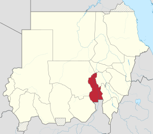 | |
Since 1994, the administrative center is the city of Rabac .
Administrative division

Counties in White Nile Province
The province is divided into 4 districts ( districts ):
- Ad Douiem
- Al-Gutaine (Al Gutaina)
- Al Jabalian
- Bones (Kosti)
Notes
- ↑ 1 2 Sudan, Eritrea, Ethiopia, Djibouti, Somalia // Peace Atlas / comp. and prepare. to ed. PKO "Cartography" in 2009; Ch. ed. G. V. Pozdnyak . - M .: PKO "Cartography": Onyx, 2010. - p. 150-151. - ISBN 978-5-85120-295-7 (Cartography). - ISBN 978-5-488-02609-4 (Onyx).