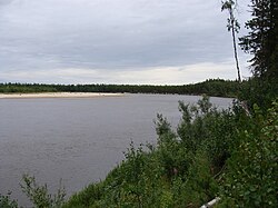
Pyakupur [2] ( obsolete. Pyaku-Pur [3] ) - a river in Russia , flows through the territory of the Purovsky district of the Yamalo-Nenets Autonomous District , the left component of the Pur river.
| Pyakupur | |
|---|---|
 | |
| Characteristic | |
| Length | 542 km |
| Swimming pool | 31,400 km² |
| Water consumption | 290 m³ / s |
| Watercourse | |
| Source | Yankyagun |
| • Coordinates | |
| Mouth | Pur |
| • Location | 389 km on the left bank |
| • Height | 34.3 m |
| • Coordinates | |
| Location | |
| Water system | Pur → Kara Sea |
| A country |
|
| Region | Yamal-Nenets Autonomous Okrug |
| Area | Purovsky district |
| HWR code | |


Content
- 1 Geographical information
- 2 Physical Information
- 3 tributaries
- 4 Water registry data
- 5 notes
- 6 References
Geographic Information
The river is 542 km long, 635 km from the source of the Yankyagun River, and the basin area is 31,400 km² . It originates from the confluence of the Yankyagun and Nyuchavotyyakha rivers on the Uplands of Siberia , flows through a swampy and wooded lowland. The food is mixed, with a predominance of snow. There are approximately 32.6 thousand lakes in the river basin, one of the largest is Lake Pyakuto . The main tributaries are Vyngapur (right) and Purpe (left). Near the city of Tarko-Sale, Pyakupur merges with the Ayvasedapur River, forming the Pur River .
Physical Information
Average water flow 290 m³ / s. High water from May to August. It freezes in October, opens in late May - early June. Pyakupur has a large number of old women . On the left bank are the city of Gubkinsky and the village of Purpe , on the right bank is the city of Tarko-Sale . Rich in fish. On the left bank of the Pyakupur are the Komsomolskoye gas and Gubkinskoye oil and gas condensate fields of the West Siberian oil and gas basin .
Tributaries
(km from the mouth)
(indicated river lengths> 50 km)
- 1 km: untitled river (ave.) [4]
- 7 km: Pankityakha (ave.)
- 30 km: Pudynayakha (BGN) [5]
- 53 km: Yaryakha (ave.)
- 55 km: Purpe (BGN) (length 327 km)
- 72 km: Hincibiyaha (ave.) (Length 81 km)
- 79 km: Yangyakha (ave.)
- 91 km: Nenyangyatarkahaha (ave.) [6]
- 96 km: Naretsyahaha (ave.)
- 99 km: Pyryahaha ( BG .)
- 109 km: Ngarka-Nyadeyakha (ave.)
- 113 km: Nyudya-Nyadeyakha (ave.)
- 117 km: Vyngapur (ave.) (Length 319 km)
- 132 km: Pyakupurparod duct (ave.)
- 141 km: Etuyaha ( BG .)
- 155 km: Harvjaha ( BG .)
- 160 km: Halokujaha (BG.)
- 183 km: Hekudyaha ( BG .)
- 199 km: Yangayaha (ave.)
- 211 km: Nyudya-Latayakha (ave.)
- 222 km: Kayayo Canal (BGN)
- 6 km: Etuyaha ( BG .)
- 231 km: Hanzomarayaha ( BG .) [7]
- 240 km: Ngarka-Latayakha (ave.) (Length 68 km)
- 282 km: Tydeyaha (lv.)
- 286 km: Langyakha (ave.)
- 290 km: Lumbatyahaha (ave.) (Length 67 km)
- 296 km: Apokuyaha ( BG .)
- 312 km: Sedeyakha (ave.) [8]
- 320.1 km: Ngarka-Varkyakha (BGN)
- 320.8 km: Nyucha-Varkyakha (BGN)
- 333 km: Kaimyakha ( BG .)
- 351 km: Hampumayaha (ave.)
- 359 km: Harucheyakha (BGN) (length 94 km)
- 355 km: Halmerjaha (BG.)
- 403 km: Hoyakha (ave.)
- 409 km: Hanayaha (ave.) (Length 72 km)
- 462 km: Ituyaha (ave.) (Length 94 km)
- 474 km: Haduteyakh (BGN)
- 480 km: Kamgayaha ( BG .) (Length 72 km)
- 500 km: Tlyapkuryakha (ave.)
- 501 km: Kuykuyaha ( BG .)
- 508 km: Iemyatyakha ( BG .)
- 510 km: Nyucha Tlyapkuryakha (ave.)
- 516 km: Kotutayaha (BGN) (length 58 km)
- 525 km: untitled (ave.) [9]
- 529 km: untitled (BGN) [10]
- 542 km: Yangyagun (BGN) (length 93 km)
- 542 km: Nyucha-Votyyakha (ave.)
Water registry data
According to the state water register of Russia, it belongs to the Nizhneobsky Basin District , the water sector of the river is Pur , there is no river sub-basin of the river. The river basin of the river is Pur [11] .
The code of the water body in the state water registry is 15040000112115300054854 [11]
Notes
- ↑ Surface Water Resources of the USSR: Hydrological Understanding. T. 15. Altai and Western Siberia. Vol. 3. Lower Irtysh and Lower Ob / ed. G. D. Eirich. - L .: Gidrometeoizdat, 1964 .-- 432 p.
- ↑ Levashov E.A. World toponymy. Adjectives from geographical names. Dictionary dictionary. - St. Petersburg, 2003 .-- S. 373. - 531 p. - ISBN 5860072929 .
- ↑ Surface Water Resources of the USSR: Hydrological Understanding. T. 15. Altai and Western Siberia. Vol. 3. Lower Irtysh and Lower Ob / ed. G. D. Eirich. - L .: Gidrometeoizdat, 1964 .-- 432 p.
- ↑ State Water Register . untitled river . textual.ru . Ministry of Natural Resources of Russia (March 29, 2009). Date of treatment December 20, 2018. Archived March 29, 2009.
- ↑ State Water Register . untitled river . textual.ru . Ministry of Natural Resources of Russia (March 29, 2009). Date of treatment December 20, 2018. Archived March 29, 2009.
- ↑ State Water Register . untitled river . textual.ru . Ministry of Natural Resources of Russia (March 29, 2009). Date of treatment December 20, 2018. Archived March 29, 2009.
- ↑ State Water Register . untitled river . textual.ru . Ministry of Natural Resources of Russia (March 29, 2009). Date of treatment December 20, 2018. Archived March 29, 2009.
- ↑ State Water Register . untitled river . textual.ru . Ministry of Natural Resources of Russia (March 29, 2009). Date of treatment December 20, 2018. Archived March 29, 2009.
- ↑ State Water Register . untitled river . textual.ru . Ministry of Natural Resources of Russia (March 29, 2009). Date of treatment December 20, 2018. Archived March 29, 2009.
- ↑ State Water Register . untitled river . textual.ru . Ministry of Natural Resources of Russia (March 29, 2009). Date of treatment December 20, 2018. Archived March 29, 2009.
- ↑ 1 2 State Water Register . Ayvaseda (P.-Pur) . textual.ru . Ministry of Natural Resources of Russia (March 29, 2009). Date of treatment December 20, 2018. Archived March 29, 2009.
Links
- Pyakupur - an article from the Great Soviet Encyclopedia .
- The Yamal River. Pyakupur