Talkov Kamen - a flooded quarry that formed a lake in Sysert District, Sverdlovsk Region , Russia . Included in the natural park Bazhovskie places .
| Lake | |
| Talc Stone | |
|---|---|
 | |
| Morphometry | |
| Absolute height | 269.6 m |
| Deepest | 32 m |
| Location | |
| A country |
|
| The subject of the Russian Federation | Sverdlovsk region |
| Area | Sysert city district |

Geographical position
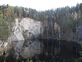
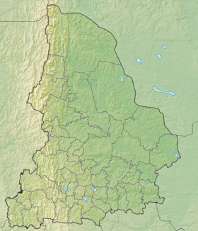
Talc Lake is a stone located in the Sysertsky urban district of the Sverdlovsk Region , 4 kilometers west of the town of Sysert , in the spurs of Chernovsk Uvala . Height above sea level - 269.6 meters. In the vicinity of the lake, at 1 km the Black River flows [1] . Over the lake, in the south-west, rises the Talc stone [2] .
History
Lake Talc Stone was formed after flooding by the waters of an abandoned talc mine. The extraction of talc slate was carried out here in the last decades of the XIX century. With the discovery in 1927 of a large deposit " Old lens " near the village. Shabrovsky talc mining on the Talc Stone finally stopped. Gradually the quarry was filled with water [1] . Since 1983, the lake with the surrounding forests has been a historical-geological, mineralogical and hydrological natural monument covering an area of 89.4 hectares [3] .
Description
Lake of irregular shape, up to 60-70 meters in length. The depth of the lake, according to the memorial plaque, is 32 meters. In the lake grow elodeya and rdesta .
On the lake are training scuba divers. It is they who say that at the eastern wall of the reservoir there is an old wooden support of the mine, which has been preserved until now. At a depth of six meters, the dam begins from fallen trunks and tree branches, so that further diving becomes a very dangerous event [1] .
Memorial plaque
Winter lake
Summer lake
Spring lake
Autumn lake
Links
Notes
- ↑ 1 2 3 Rundkvist N., Zadorina O. Sverdlovsk Region. From A to Z: The Illustrated Local Lore Encyclopedia . - Ekaterinburg: Kvist, 2009. - p. 456. - ISBN 978-5-85383-392-0 .
- ↑ O-41-122-C Map Sheet - FSUE “GOSGISTSENTR”
- ↑ Lake "Talc Stone" with surrounding forests