
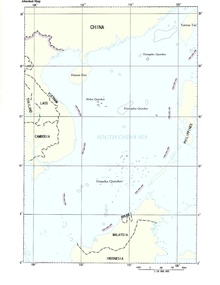
The nine-dotted line, the U-shaped line, or the nine-dash map is the line that China uses to determine its territorial requirements in the South China Sea . These are the Paracel Islands (occupied by China), to which Vietnam and Taiwan have claims, the Spratly Islands , whose ownership is disputed by the Philippines , China, Brunei , Malaysia , Taiwan and Vietnam (they predictably have oil deposits), and some others. A map with a “nine-dotted line” was introduced by the nationalist government of China in 1947. In Vietnam, it is also known as Đường lưỡi bò - "map of the cow's tongue", a map of the "path of the cow's tongue." According to Chinese sources, this line first appeared in February 1948 as a U-shaped line of eleven dotted lines on maps that were published in private publications in China. However, according to the decision of the Chinese government to transfer the island of Batlongwi and the adjacent waters to Vietnam, in 1953, changes were made to the Prime Minister of China Zhou Enlai , as a result of which the now-known "nine-dot line" appeared.
This line defines the zone of Chinese interests in the waters of the South China Sea from mainland China and Hainan Island to the coast of Malaysia and Brunei almost at the equator [1] .