Doni ( Fin. Tonnila ) - a village in the Gatchina district of the Leningrad region . It is part of the Verevsky rural settlement .
| Village | |
| Doni | |
|---|---|
| A country | |
| Subject of the federation | Leningrad region |
| Municipal District | Gatchinsky |
| Rural settlement | Verevskoye |
| History and Geography | |
| First mention | 1817 year |
| Former names | Tonilova, Donnie, Donno |
| Center height | 95 m |
| Timezone | UTC + 3 |
| Population | |
| Population | ▲ 53 [1] people ( 2017 ) |
| Digital identifiers | |
| Telephone code | +7 81371 |
| Postcode | 188354 |
| OKATO Code | 41218816008 |
| OKTMO Code | |
Content
- 1 History
- 2 Geography
- 3 Demographics
- 4 Transport
- 5 Gardening
- 6 notes
History
On the “Topographic map of the environs of St. Petersburg” of the Military Topographic Depot of the General Staff of 1817, it is designated as the village of Tonilova from 5 yards [2] .
As the village of Donny from 3 yards, it is mentioned on the “Topographic Map of the Environs of St. Petersburg” by F. F. Schubert in 1831 [3] .
DONNY - the village belongs to Samoilova , the countess, the number of inhabitants according to the audit: 11 m., 17 w. p. (1838) [4]
In the explanatory text to the ethnographic map of the St. Petersburg province of P.I. Köppen in 1849, it is referred to as the village of Tonnila ( Donny ), and also the number of its inhabitants for 1848 is indicated: Ingermanlanders - Savakot - 13 m., 15 w. n., a total of 28 people [5] .
According to the “Topographic Map of Parts of the St. Petersburg and Vyborg Provinces” of 1860, the village of Donny consisted of 2 peasant households [6] .
DONNY - the village is specific at the well, the number of yards is 2, the number of inhabitants: 15 m., 17 w. p. (1862) [7]
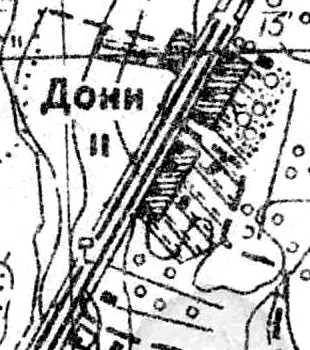
Plan of the village of Doni. 1885
In 1885, the village of Doni had 2 courtyards.
In the 19th century, the village administratively belonged to the Mozinsky volost of the 1st camp of the Tsarskoye Selo district of St. Petersburg province, at the beginning of the 20th century - of the 4th camp.
By 1913, the number of yards increased to 4 [8] .
From 1917 to 1923, the village of Donny was part of the Pendovsky Village Council of the Mozinsky volost of the Detskoselsky district .
Since 1923, as part of the Gatchina volost [9] .
In 1928, the population of the village of Donnie was 56 people [9] .
According to administrative data of 1933, the village was called Donny and was part of the Pendovsky village council of the Krasnogvardeisky district . The village council included the following villages: Donny , Zaitsevo , Kovrovo, Kommolovo , Kondapokshino, Ontolovo, Pendolovo, Ripshevo [10] .
According to 1936, the village was called Donno and was the administrative center of the Pendovsky Finnish National Village Council , which included 8 settlements, 338 farms and 8 collective farms [11] .
According to a topographic map of 1939, the village was called Doni and consisted of 11 yards.
Since 1954, as part of the Romanovsky Village Council.
In 1958, the population of the village of Donnie was 102 people.
Since 1959, as part of the Bolshetaitsky village council [9] .
According to the data of 1966 and 1973, the village was called Doni and was part of the Bolshetaitsky village council [12] [13] .
According to 1990, the village of Doni was part of the Verevsky Village Council [14] .
In 1997, 13 people lived in the village, in 2002 - 16 people (all Russians) [15] [16] .
As of January 1, 2006, there were 2 households and 12 dachas in the village, the total population was 18 people [17] .
In 2007, 20 people [18] .
Geography
The village is located in the northern part of the district on the P23 Pskov highway ( E 95 , St. Petersburg - the border with Belarus ).
The distance to the administrative center of the settlement - the village of Maloe Verevo , 9 km [18] .
The distance to the nearest railway station Verevo is 2.5 km [12] .
Demographics
Transport
From Gatchina and St. Petersburg to the village of Doni can be reached by buses number 431, 18, 18A, 100.
Gardening
Doni [19] .
Notes
- ↑ Administrative and territorial division of the Leningrad region / Comp. Kozhevnikov V.G. - Directory. - SPb. : Inkeri, 2017 .-- S. 109 .-- 271 p. - 3000 copies. Archived March 14, 2018 on Wayback Machine
- ↑ "Topographic map of the circle of St. Petersburg" on 16 sheets on a scale of 1 century. in 1 dm. or 1: 42,000, Military Topographic Depot of the General Staff, 1817
- ↑ “Topographic map of the environs of St. Petersburg”, shot under the direction of Lieutenant General Schubert and engraved at the military topographic depot. 1831 year
- ↑ Description of the St. Petersburg province in counties and camps . - SPb. : Provincial Printing House, 1838. - S. 23. - 144 p.
- ↑ Köppen P. von. Erklarender Text zu der ethnographischen Karte des St. Petersburger Gouvernements. - St. Petersburg, 1867, p. 57
- ↑ Map of the St. Petersburg province. 1860
- ↑ Lists of populated areas of the Russian Empire, compiled and published by the Central Statistical Committee of the Ministry of the Interior. XXXVII. St. Petersburg province. As of 1862. SPb. 1864.S. 160
- ↑ "Map of the area of maneuvers" 1913
- ↑ 1 2 3 Handbook of the history of the administrative-territorial division of the Leningrad Region (Unavailable link) . Date of treatment September 22, 2015. Archived March 6, 2016.
- ↑ Administrative territorial division of the Leningrad region. - L., 1933, S. 253
- ↑ Administrative and economic guide to the Leningrad region. - L., 1936, p. 148
- ↑ 1 2 Administrative and territorial division of the Leningrad region / Comp. T.A. Badina. - Reference book. - L .: Lenizdat , 1966 .-- S. 88. - 197 p. - 8000 copies.
- ↑ Administrative territorial division of the Leningrad region. - Lenizdat. 1973. S. 215
- ↑ Administrative territorial division of the Leningrad region. Lenizdat. 1990. ISBN 5-289-00612-5. S. 62
- ↑ Administrative territorial division of the Leningrad region. SPb. 1997. ISBN 5-86153-055-6. S. 63
- ↑ Koryakov Yu. B. Database “Ethno-linguistic composition of Russian settlements”. Leningrad region .
- ↑ List of population and households of Verevsky volost as of January 1, 2006
- ↑ 1 2 Administrative and territorial division of the Leningrad Region. - SPb. 2007.S. 87
- ↑ System "Tax Reference". Directory of postal codes. Gatchinsky district, Leningrad region