Lovozero district is an administrative-territorial unit ( district ) and a municipality ( municipal district ) in the Murmansk region .
| Municipal District | |||
| Lovozero district | |||
|---|---|---|---|
| |||
| A country | |||
| Included in | Murmansk region | ||
| Includes | 2 municipalities | ||
| Adm. Centre | Lovozero village | ||
| History and Geography | |||
| Date of formation | |||
| Square | 52 978 km² (1st place ) | ||
| Timezone | MSK ( UTC + 3 ) | ||
| Population | |||
| Population | ↗ 11 014 [1] people ( 2018 ) ( 16th place ) | ||
| Density | 0.26 people / km² (19th place) | ||
| Official language | Russian | ||
| Coordinates | |||
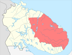 | |||

The administrative center is the village of Lovozero .
Content
Geography
The area of the district is 52 978 km². Located in the central and northeastern parts of the region. It occupies most of the Kola Peninsula .
In the north and east, the area is washed by the Barents and White Seas. In the west it borders with the Kola region (the rural settlement of Teriberka , the urban settlement of Tumanny and the rural settlement of Pushnoy ), the urban districts of Olenegorsk and the city of Kirovsk ; in the south - with the Tersky district (the urban settlement of Umba and the rural settlement of Varzuga ); on the northern coast of the district is the closed city of Ostrovnoy . In the east, the region is separated from the Arkhangelsk region by a strait 50 km wide.
The area is almost entirely beyond the Arctic Circle . It is poorly populated, the territory mainly belongs to the tundra zone.
The climate of the region on the coast of the Barents Sea is subarctic marine, humid. As you move away from the coast, the severity of the climate increases. The average January-February temperatures are -9-10 degrees in the far north and -13-15 degrees in areas remote from the sea. July, respectively, + 9 + 11 and +14 degrees. Winter is long, with frequent lingering snowstorms. Summer is short, cool and rainy. Frosts are possible on any day of summer; in June snowfalls are not rare. Frosts are very difficult to tolerate due to high humidity and strong winds.
History
The district was formed on the lands of the former Lovozero volost in 1927 as part of the Murmansk district . In 1931 received the status of a national (Komi-Saami-Nenets) region. Since the late 1930s, the area has ceased to be called national. In 1963, the majority of the abolished Sami region became part of the district .
Population
| Population | ||||||
|---|---|---|---|---|---|---|
| 1989 [2] | 2002 [3] | 2009 [4] | 2010 [5] | 2011 [6] | 2012 [7] | 2013 [8] |
| 18 263 | ↘ 14 311 | ↘ 12 887 | ↘ 11 820 | ↘ 11 784 | ↘ 11 471 | ↘ 11 326 |
| 2014 [9] | 2015 [10] | 2016 [11] | 2017 [12] | 2018 [1] | ||
| ↘ 11 121 | ↘ 11,000 | ↘ 10 931 | ↘ 10 910 | ↗ 11 014 | ||
The population of the district, according to the 2010 All-Russian Population Census , is 11,820 people, of which 6,180 are men (52.3%) and 5640 are women (47.7%) [13] [14] . The largest settlements: Revda (8.4 thousand people) and Lovozero (2.9 thousand people). The Lovozero district is the main place of compact residence in the Murmansk region of the indigenous peoples of the North ( Sami , Komi , Nenets , etc.). Their share in the total population of the region is more than 17%. Most representatives of these peoples (more than 800 people) live in rural areas. [15]
The national composition of the district according to the 2002 census: [16]
- Russians - 10,098 (70.56%)
- Komi - 1438 people. (10.05%)
- Sami - 1012 people (7.07%)
- Ukrainians - 792 people (5.53%)
- Belarusians - 226 people (1.58%)
- Mordovians - 107 people. (0.75%)
- Nenets - 106 people (0.74%)
- total - 14311 people. (100.00%)
According to the 2010 census, 72.0% of the population of the municipality are Russians , 4.3% are Ukrainians , 1.3% are Belarusians , and 22.2% are of other nationalities [17] . A significant proportion of Sami and Komi.
District Composition
- City settlement Revda :
- Revda
- Rural settlement Lovozero :
- Lovozero
- Kanevka
- Krasnoshchelye
- Sosnovka
On September 28, 2006, the village of Kharlovka was abolished [18] , and on November 29, 2009 the village of Kharlov Island [19] was abolished.
Economics
The main industry is non - ferrous metallurgy . On the territory of the Lovozersky tundra mountain range there is the Lovozerskoe deposit of rare earth metals . Loparite concentrate is produced by Lovozero Mining and Processing Plant LLC. Due to the lack of demand for products in Russia, the company is currently in a difficult economic situation.
The leading sector of the economy of the region is agriculture , represented by two agricultural cooperatives Tundra (in the village of Lovozero) and Olenevod (in the village of Krasnoshchelye, with branches in the villages of Kanevka and Sosnovka). The main directions of their activity is the production of venison meat. Also on the territory of the district is the Lovozero Forestry .
There are subsidiary enterprises and crafts engaged in the manufacture of fur products (shoes, clothes, hats), souvenirs made of wood, deer bone, etc.
Transport
Road infrastructure is poorly developed. Transport communication between Murmansk and the villages of Lovozero and Revda is carried out by road, with remote villages of the Krasnoshchelye , Kanevka and Sosnovka districts - communication by air, by sea - only to the village of Sosnovka during the navigation period.
Links
Notes
- ↑ 1 2 Population of the Russian Federation by municipalities as of January 1, 2018 Date of treatment July 25, 2018. Archived July 26, 2018.
- ↑ All-Union Population Census of 1989 . Archived August 23, 2011.
- ↑ 2002 All-Russian Population Census. Tom. 1, table 4. The population of Russia, federal districts, constituent entities of the Russian Federation, regions, urban settlements, rural settlements - district centers and rural settlements with a population of 3 thousand or more . Archived February 3, 2012.
- ↑ The number of permanent population of the Russian Federation by cities, urban-type settlements and regions as of January 1, 2009 . Date of treatment January 2, 2014. Archived January 2, 2014.
- ↑ 2010 All-Russian Population Census. Volume 1 "The number, location and age and sex composition of the population of the Murmansk region" . Date of treatment February 2, 2014. Archived February 2, 2014.
- ↑ Murmansk region. Estimated resident population as of January 1, 2009-2015
- ↑ Population of the Russian Federation by municipalities. Table 35. Estimated resident population as of January 1, 2012 . Date of treatment May 31, 2014. Archived May 31, 2014.
- ↑ The population of the Russian Federation by municipalities as of January 1, 2013. - M.: Federal State Statistics Service of Rosstat, 2013. - 528 p. (Table 33. The population of urban districts, municipalities, urban and rural settlements, urban settlements, rural settlements) . Date of treatment November 16, 2013. Archived November 16, 2013.
- ↑ Table 33. The population of the Russian Federation by municipalities as of January 1, 2014 . Date of treatment August 2, 2014. Archived on August 2, 2014.
- ↑ The population of the Russian Federation by municipalities as of January 1, 2015 . Date of treatment August 6, 2015. Archived on August 6, 2015.
- ↑ Population of the Russian Federation by municipalities as of January 1, 2016
- ↑ The population of the Russian Federation by municipalities as of January 1, 2017 (July 31, 2017). Date of treatment July 31, 2017. Archived July 31, 2017.
- ↑ Statistical digest Number, distribution and age and sex composition of the population of the Murmansk region. The results of the All-Russian population census. Volume 1. 2012 Archived December 22, 2012. / Federal State Statistics Service, Territorial Authority of the Federal State Statistics Service for the Murmansk Region. Murmansk, 2012 - 75 p.
- ↑ Population of the Murmansk region by gender as of October 14, 2010 (inaccessible link)
- ↑ The indigenous inhabitants of the Sami and Karelian region in Murmansk find work in the region with great difficulty (Inaccessible link) . Date of treatment September 17, 2011. Archived September 24, 2015.
- ↑ 2002 All-Russian Census: Table 34r-Murman M .: Federal State Statistics Service, 2004. ( 2002zip , see note )
- ↑ Distribution of the population of the Murmansk region by the most numerous nationalities by municipalities
- ↑ Law of the Murmansk Region dated September 29, 2006 No. 793-01-ЗМО “ On the Elimination of Certain Populated Points of the Murmansk Region”
- Jump up