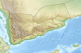
Radfan or Mountains Radfan [1] ( Arabic: ردفان ) is an inaccessible mountainous region [2] in the territory of Lahj governorate , Yemen .
| Radfan | |
|---|---|
| Arab. ردفان | |
| Characteristics | |
| Area | more than 1000 square kilometers km² |
| Highest point | |
| Highest peak | Jebel Hurria |
| Highest point | 1863 m |
| Location | |
| A country |
|
| Regions | Ed Dali , Lahj |

Content
- 1 History
- 2 Geography
- 3 Demographics
- 4 Climate from memories
- 5 notes
History
Back in the period of the Federation of South Arabia (1963-1967), the mountains of Radfan belonged to the emirate of Dal .
On October 14, 1963, in the mountainous region of Radfan, the emirate of Dala , an anti-British armed uprising broke out, led by the Popular Front for the Liberation of South Yemen , which was the impetus for the struggle for the independence of South Yemen . [2] This armed rebellion turned into a real war between the Yemenis and the British troops.
As for the locals of the mountainous region of Radfan, the commander of 45 Commando, Lt. Col. Stevens, spoke of them as "hostile to all strangers, armed with a rifle since childhood, who regard the appearance of the British as an opportunity to practice shooting." [2]
In the fall of 1967, British troops withdrew from South Yemen. On November 30, 1967, the new state of the People’s Democratic Republic of Yemen was formed and the Federation of South Arabia was abolished, the map was redrawn and the mountains of Radfan began to belong to Lahj governorate .
Geography
Jebel Radfan, an inaccessible mountainous region with an area of more than a thousand square kilometers, lies east of the Dhala (Dala) road, which goes from Aden to the north through the town of Dhala (Arabic name is Ad-Dali) to the border of Northern Yemen and further leads to the capital of Yemen, Sana'a . [3] [2]
The highest point is Jebel Hurria (1867 meters). [3]
High peaks, jagged cliffs, deep wadi gorges in which from time immemorial people lived on the verge of life and death, in an atmosphere of bloody revenge that has continued for centuries. [3]
Demographics
In the mid-1960s, about 30 thousand people lived in Jebel Radfan, who could put up to 7 thousand well-trained fighters. [3]
Climate from Memories
Pete Sholey, who participated in military events in the Radfan Mountains in 1964 in the ranks of the SAS , wrote in his book “SAS Heroes”:
During the day, the air temperature in the shade reached 49 degrees Celsius, and at night frosts occurred.
- [4]
More from the memories of the British military about the war in the mountains in 1964:
The sun, heat up to + 55 degrees, local water contaminated with bilgaria parasite should not be consumed.
- [3]
Notes
- ↑ Topographic maps of the General Staff
- ↑ 1 2 3 4 40 COMMANDO ROYAL MARINES >> ROYAL MARINES in Aden 1960s
- ↑ 1 2 3 4 5 LiveJournal >> The Radfan Campaign - The Nutcracker. Summary based on "Aden Insurgency: The Savage War in South Arabia 1962-67" by Jonathan Walker and "The Long Summer: 45 Commando RM 1963-1964" by T.M. Stevens.
- ↑ Brotherhood Magazine >> Professionals: Pete Scholey: “SAS gave me an understanding of the value of life.” May 2012. Prepared by Sergey Kozlov. Information about the book “Heroes of SAS” can be found at: www.ospreysas.com