Umba is a river on the Kola Peninsula in the Murmansk region of Russia . The city of Kirovsk with the territory under its jurisdiction flows through the territories of the Terek district and the urban district.
| Umba | |
|---|---|
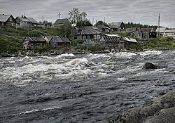 Old Umba Old Umba | |
| Characteristic | |
| Length | 123 km |
| Pool | 6250 km² |
| Water flow | 78.2 m³ / s |
| Watercourse | |
| Source | Umbozero |
| • Height | 149 m |
| • Coordinates | |
| Mouth | Kandalaksha Bay |
| • Height | 0 m |
| • Coordinates | |
| River slope | 0.83 m / km |
| Location | |
| Water system | White Sea |
| A country |
|
| Region | Murmansk region |
| HWR Code | |

The length is 123 km. The basin area is 6,250 km².
The name of the Umba River comes from the Sámi word Umb or Ump - “ closed ” [2] The river got its name from its source, Lake Umbozero , located between the Khibiny and the Lovozero tundras and thus closed on all sides [2] . According to another version, the river coast was settled from the sea, and seafarers did not immediately recognize the mouth of the river and called the river the word “umba” - “closed” .


The source of the river is located at the exit from Umbozero , flows through the lakes Kapustnye , Kanozero and Ponchozero . It falls into the Kandalaksha Bay of the White Sea . Food mainly snow and rain. The flood - in May-November. Average water consumption is 78.2 m³ / s. Ice cover at the end of October - mid December, ice drift in May - June. Alloy. Empty [3] . Spawning salmon . The river flows in a valley framed by stony mountains. Significant forests grow along the river valley and the surrounding mountains, and in its lower reaches there are convenient mowings. [four]
The main tributaries are the Charius , the Black , the Lake Creek , the Crow , the Fir, and the Wyala . After Kanozero, on a small section it is divided into three channels: Kitsa (7.7 km), Nizma (15 km), Rodving (7.7 km), forming Porfirev Islands and Krivetsky .
On the river is located urban-type settlement Umba [5] [6] [7] .
Literature
- Umba // Acorns - Fidel. - Moscow : Soviet Encyclopedia, 1956. - P. 224. - ( Great Soviet Encyclopedia : [in 51 t.] / Ed. B.A. Vvedensky ; 1949-1958, t. 44).
Notes
- ↑ Surface water resources of the USSR: Hydrological knowledge. T. 1. Kola Peninsula / ed. Yu. A. Elshina. - L .: Gidrometeoizdat, 1969. - 134 p.
- ↑ 1 2 Minkin A. A. Toponyms of Murman. - Murmansk: Murmansk book publishing house, 1976.
- ↑ Umba (river) - an article from the Great Soviet Encyclopedia .
- ↑ Umba, the river of the Arkhangelsk province // Brockhaus and Efron Encyclopedic Dictionary : 86 tons (82 tons and 4 extras). - SPb. , 1890-1907.
- ↑ Map sheet Q-36-5,6 Monchegorsk . Scale: 1: 100,000. State of the area in 1980. 1986 edition
- ↑ Map sheet Q-36-11,12 Mount Wahnbed . Scale: 1: 100,000. 1978 Edition.
- ↑ Map sheet Q-36-17,18 Polar Dawns . Scale: 1: 100,000. State of the area in 1981. 1986 edition