
The relief of Belarus as a whole has a flat character with a fluctuation of heights from 80 to 345 meters above the level of the Baltic Sea .
Content
General characteristics
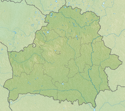
The Republic of Belarus is located on the East European Plain . The relief of the territory of Belarus is characterized by a predominance of flat and gently undulating plains and lowlands, river valleys and ridge-hilly complexes of various sizes and configurations. Absolute heights range from 345 m ( Dzerzhinsk mountain on the Minsk Upland ) to 80 m in the Neman Valley near the border with Lithuania . The average height of the surface of Belarus is 160 m above sea level.
Most of the elevations, which account for about a third of the territory, are located in the western and central parts of the country and have absolute heights from 200 to 300 m. The depth of dissection of lower interfluvial areas usually does not exceed 5 m, on elevated flat areas it increases to 5-10 m up to 10-40 m and more. In some cases, height fluctuations can be up to 50-100 m due to erosion incisions . Dismemberment density (the length of the erosion network per 1 km² of territory) in the lowlands is 0-0.2 km / km², on more elevated plains - up to 0.3-0.5 km / km², on the slopes of the edge ridges and near large river valleys - 1.0—2.0, less frequently 3.0— 3.5 km / km².
Reliefs are mainly deposits of the Quaternary period (the actual glacial moraines , stream-glacial and lake-glacial). Their thickness ranges from a few meters to 300 m and more (75-80 m on average). The degree of denudation transformation, morphological features and age of the relief vary from north to south.
The northern part is dominated by glacial relief of the Poozersky glaciation with many lakes (about 3000), drainless depressions, flat marshy lowlands, bordered and separated by groups of hills and systems of winding-branched edge ridges. Absolute heights range mainly from 120-170 m in lowlands and plains to 250 m within elevations and ridges. In the central part of the region, the relief is denudated, predominantly glacial of the Sozhsky age. A system of marginal elevations and plate-like plains, which are part of the watershed of the Baltic and Black Seas basins, is developed. Absolute heights reach 200-250 m and more. In the south, the extended denudated relief of the Sozh and Dnieper ages, as well as the alluvial and lake-alluvial relief of the Posozero-Holocene age. Absolute heights are 120–185 m, occasionally exceeding 200 m. The lowest levels of the earth’s surface throughout the region are confined to river valleys, the largest of which last for hundreds of kilometers. They are essentially an intrazonal relief category. The rivers of Belarus belong to the Black basins (58% of the country's territory is drained) and the Baltic seas. In the valleys of the major rivers of the Black Sea basin, two or three levels of floodplain and two terraces above the floodplain are usually distinguished; in the rivers of the Baltic basin, two or three levels of floodplain, two or three cyclone terraces and several local terraces (up to eight or nine at the Neman).
The most elevated is the central part of Belarus - the Belarusian ridge . Here is the Minsk Upland , on which is the highest point of Belarus - Mount Dzerzhinsk (345 m); a number of points have a height of more than 300 m - Lysaya , Mayak and other mountains. Slightly inferior to the Minsk Upland in absolute heights Novogrudskaya ( Zamkovaya Mountain - 323 m), Oshmyanskaya , Vitebsk Uplands. The largest lowlands in the territory of Belarus: Polesskaya , Neman , Polotsk , Narochana-Vileika .
The relief features of Belarus are closely related to the geological structure of the territory. Elevations are confined to the elevated portions of the crystalline basement. Territories with deep deposits of the crystalline basement are usually occupied by lowlands.
The primary view of the earth's surface in a large part of the territory of Belarus is modified, and in some places completely destroyed by later erosion-denudation processes, and especially man-made activities. Man-made forms (quarries, dams, pits, dumps, etc.) are often comparable in size to the forms of natural relief, and in total area occupy 4-5% of the entire territory. Intense anthropogenic impact on the earth's surface leads to the disappearance of many characteristic landforms ( oz , kama , regional glacial ridges, etc.), which makes it very relevant to justify and isolate geomorphological monuments of nature, reserves and reserves.
Relief Formation
The decisive factor in the formation of the relief of Belarus were glaciers . Over the past 500-600 thousand years, the territory of Belarus has experienced at least 5 glaciations. Glaciers were advancing into the territory of Belarus, mainly from Scandinavia . The longest was the Dnieper glaciation , which covered the entire territory of Belarus. Last glaciation - Poozersk ; the glacier, which left the territory of Belarus about 10 thousand years ago, occupied only the north of Belarus.
Glacial deposits transported by the glacier are called moraine . Moraine deposits in Belarus consist of sand and clay, gravel , pebbles, boulders. Ancient glaciers formed moraine hills, hills, ridges and plains. The most characteristic moraine forms of relief for Northern and Central Belarus are: the Belarusian ridge , the Vitebsk Upland , the Braslav ridge and others. Water-glacial (fluvioglacial) plains and lowlands, such as the Central Berezinskaya Plain, have been created by streams of melt glacier water. Their surface is composed mainly of sandy sediments, flat and slightly undulating, often swampy. After the glacier melted, large glacial lakes appeared. Later they were lowered along the rivers. Now in their place - lake-glacial lowlands (for example, the Polotsk lowland ).
Another factor in the formation of the modern relief of Belarus was the activity of the rivers that created the river valleys . Large rivers have valleys several kilometers wide. The greatest widths are the valleys of the rivers in Polesye , for example, the width of the Pripyat valley reaches 75 km.
The modern relief changes under the influence of not only natural, but also anthropogenic factors. Careers arise at the mining sites, and waste heaps are formed from waste dumps (for example, potash production waste near Soligorsk ).
Types and forms of relief
Taxonomic units of the classification of the relief of Belarus:
- class;
- Group;
- type of;
- subtype;
- the form.
The main genetic types of relief:
- glacial;
- glacial water;
- lake-glacial;
- alluvial;
- lake-alluvial,
- fluvial;
- suffosion-karst;
- eolian
- lake-marsh;
- slope;
- gravitational,
- man-made.
Geomorphic zoning
| Physical and geographical zoning of Belarus | ||
A. Subzone of mixed forests
|
B. Subzone deciduous forests
| |
Classification
According to the features of the spatial differentiation of the structure of the earth's surface on the territory of Belarus, four geomorphological areas are distinguished:
- Belarusian Lake District;
- Belorussian elevations and ridges (West Belarusian and East Belarusian subregions)
- plains and lowlands of Preforestation;
- lowlands Polesia.
Belorussian Poozerya Region
The region of the Belarusian Lake District is characterized by the prevalence of flat marshy glacier-lake lowlands and plains, many lakes and drainage basins. The surface of the region as a whole has a depression-like shape, and the raised edges are created by glacial ridges and elevations of the Poozero glaciation, which continue beyond the borders of Belarus - on the territory of Russia and Lithuania. The southern boundary of the region basically coincides with the boundary of the expansion of the last ice sheet. Absolute elevations in the central part are 120–160 m, along river valleys - 100–125 m. The eastern part is more elevated (above 150 m). The regional ridges and elevations reach 200–260 m above sea level, and on the Vitebsk Upland - almost 300 m. The forms of the regional glacial relief — ridges, ridges, hills — are fairly well represented; the largest of them are the Braslavskaya ridge , the Gorodok upland , the Vitebsk upland and the Sventsyansky ridge . The strips of the regional relief are divided by lake-glacial, fluvioglacial and moraine lowlands and plains. Glacial-lowland lowlands and plains spread along the Western Dvina valley and in the Luchos river basin. Their surface is most lowered in the west. The external homogeneity of the lake-glacial lowlands is disturbed by kamovo hills 7–8 m high, occasionally 15–20 m, ozovy ridges 10 m high, occasionally up to 30 m. Hilly-dune massifs up to 20 m high are also characteristic. The marginal parts of the former glacial pools are confined to flat abrasive sites up to 5-7 km wide with a clearly defined ledge. Fluvioglacial deltas with a height of 2-10 m are spread around the periphery of the Polotsk and Luchosky near-glacial lakes and other water bodies within the borders of the Poozero glacier. There are peculiar ring forms of pingo near the coastal zones. The territory of the Belarusian Lake District is drained by a dense network of rivers belonging to the Western Dvina and Neman basins. River valleys are young, narrow and deep. Lakeland has about 3000 lakes. Their hollows have a diverse origin and are dammed, exactional, thermokarst, erosive and complex) and reach maximum sizes for Belarus.
Region of the central Belarusian hills and ridges
The region of the central Belarusian hills and ridges is characterized by the development of the most powerful regional glacial formations of the Sozhsky age. The denudation ridge-hilly relief with flat peaks and deep erosion dismemberment prevails. Losslike deposits are often found on the marginal formations, with which the distribution of gullies and suffosial depressions is associated. The river valleys developed, although there are narrow and deep, with rocky bottom and rapids. Absolute elevations reach 200-250 m. The highest are Dzerzhinsk Mountain (345 m), Lysaya Mountain (342 m). According to the structure of the relief, the region is divided into subregions: the Western-Belarusian (characterized by the greatest absolute and relative heights, a variety of glacial forms, large glaciodislocations ) and East Belarusian (the relief is mainly plate-like, the absolute heights are reduced and the horizontal and vertical disintegration decreases). The main reason is the difference in tectonic structure. The western part of the region is confined to the Belarusian anticlance, the eastern - to the Orsha depression, which was manifested in the peculiarities of the preglacial and glacial relief and the dynamics of the glaciers. The highest absolute heights are associated with regional glacial formations ( Minsk Upland , Oshmyany Upland , Novogrudsky Upland , Slonim Upland, Volkovysk Upland, Grodno Upland, Kopyl Ridge and others). The development of glaciodislocations, blocks of Cretaceous and other rocks is characteristic of almost all regional elevations. Especially large glaciodislocations were found within the Grodno, Volkovyssk and Minsk heights. Significant areas are occupied by moraine plains with absolute heights of 145–190 m. The relief is predominantly gently wavy, occasionally fractional-mound, there are thermokarst depressions, troughs of melt water, which are sometimes inherited by small rivers, kams , ozes and marginal ridges up to 10—12 m. On the moraine plain in the eastern part of Belarus, the cover of loess-like deposits often lies, which led to the widespread development of ravines, hollows, gullouts, embedded to a depth of 20-30 m, suffosion depressions with a diameter of 100-200 m and a depth of 2—3 m. e moraine plain areas distributed almost everywhere fluvioglacial surfaces with altitudes 135-170 m and the relative vibrations -. 5.3 m on some sections preserved wetlands and overgrowing lake basin. Characteristic elements of the relief are eolian ridges and hills, hollows of runoff, in some places heavily swamped. The lowest hypsometric level within the region is occupied by glacial and lake-alluvial lowlands and plains, whose areas are small. The hydraulic network refers to the basins of the Baltic and Black Seas. There are relatively few lakes in the region.
Plains and Lowlands
The region of the plains and lowlands of the Preforestation is a transitional orographic step between the highlands of Central Belarus and the Polesye Lowland. The modern relief was formed as a result of the accumulative, exactional and stationing activity of glaciers in the Sozh and Dnieper times. Sandy (fluvioglacial) plains are widespread, bordering the belt of the largest hills and ridges in the country from the south. Regional complexes are common in small areas and have absolute elevations of 170–200 m, rarely 210–220 m. Below are areas of moraine plains with absolute heights of 160–180 m. Their topography is gently undulating with fluctuations of relative heights up to 2–3 m, occasionally fractional-mound with fluctuations in heights of up to 5-7 m. In the eastern part of the region, the moraine surface is often overlapped by loess-like sediments, on which suffusion depressions and a ravine-gully network develop. Thermocarst and karst depressions, hollows of melt runoff are found everywhere. Below the moraine plain are the areas of the flivioglacial (sandy) plains, which are predominant on the territory of the Pre-forest area. Their hollow-wavy surface has absolute heights of 140–180 m, often heavily swamped. There are separate ridges of the regional relief, Kama and Ozy up to 5-7 m high. Positive relief forms are also formed by aeolian processes (the height of the ridges and dunes does not exceed 10 m). In the eastern part of the region, water-glacial deposits are blocked by loess-like ones, and therefore suffusion depressions and gully-hollow systems are common here. Thermokarst depressions and peated troughs of runoff are found everywhere. Many hollows are inherited by rivers. Below the fluvioglacial plains and lowlands, flat, gently wavy, strongly swamped lake-alluvial surfaces with absolute heights of 130–160 m occur everywhere. Many residual growing lakes, eolian ridges and hills up to 5 m in height can be found. belonging to the Pripyat , Berezina , Dnieper , Sozh basins, and to a lesser extent, the Western Bug and Neman . The river valleys are developed, wide and asymmetrical. Lakes are few.
Region of the Polissya Lowland
The region of the Polissya lowland is characterized by the wide development of highly marshy alluvial, lake-alluvial and water-glacial plains with various forms of eolian accumulation. The elevated parts of the marginal glacial formations, moraine and water-glacial plains (with the exception of the Mozyr Upland and the Suburban area ) have a limited distribution, but form a strip elongated in a sublatitudinal direction, which give a wavy character to the Polesye relief. The river valleys are wide, floodplains reach significant sizes. According to the tectonic structure, the region is divided into two subregions: Belarusian Polesye (formed mainly on the territory with a relatively deep occurrence of crystalline rocks) and Ukrainian Polesye (characterized by a higher occurrence of the crystalline basement). The skeleton of the relief, its waviness are created mainly by the glacial processes of the Dnieper period ; in the formation of the eastern edge of the lowland took part the glacier of the Sozh time , the southern - the tectonic movements. Maximum absolute heights are associated with regional formations, among which are the Mozyr Upland and the Zagodie. Within the Mozyr Upland, absolute heights reach maximum values for Polesia - 220.7 m (near the village of Pin of the Mozyr District), and relative heights up to 80 m. A characteristic feature of the Mozyr Upland is the intense dissection of the gully-flat network (20-30 pieces / km² ). The largest hollows have a length of up to 3 km and a depth of cut of up to 70 m. For the marginal glacial formations of Zagorod'e, there is a characteristic ridge relief with flat peaks and gentle slopes. Absolute altitudes of 140-175 m prevail, relative altitudes of 10-15 m. Below the marginal glacial formations are hollow-wavy moraine plains with absolute heights of 150-160 m (limited distribution). A tier below (125–150 m) spread out gently undulating and flat, often waterlogged water-glacial plains and lowlands. On fluvioglacial surfaces there are many eolian hills, ridges, dunes with a height of up to 10 m, fields of re-sands. The lowest tier is occupied by flat, weakly wavy areas of lake and lake-alluvial marshy lowlands, among which are overgrown lakes, ground hollows and basins of former lakes. The territory of the Polesye Lowland is drained mainly by the rivers of the Pripyat basin and, to a lesser extent, by the tributaries of the Sozh , Dnieper and the Bug .
Literature
- A.V. Matsevei, L.A. Nechiparenko, Belarus Relief // BE ў 18 t. T. 18. Book. 2. Republic of Belarus. - Minsk: BelEn, 2004.
- Matsveiў A.V., Yakushka V.P. Prarelef Belarusi. Pl., 1994. 72 p.
- Geomorphology of Belarus: studies. allowance for stud. geogr. fact /ABOUT. F. Yakushko, L. V. Maryina, Yu. N. Emelyanov; by ed. O. F Yakushko. Mn., 2000. 172 p.
- Matveev A.V., Gursky B.N., Levitskaya R.I. Relief of Belarus. - Minsk: University, 1988.
- Physical geography of Belarus: vucheb. dap for stud. geagr. fact / pad red. B.M. Gurskaga, K.K. Kudlo. - Minsk, 1995. 192 p.