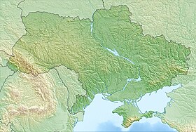
Tiligulsky estuary [2] - an estuary in the Odessa and Nikolaev regions of Ukraine , on the Black Sea coast [2] . Length - 80 km, width - 0.2-3.5 km, depth - up to 19 m. The area of the estuary is about 170 km². Separated from the sea by an embankment with a width of about 4 km and a length of up to 7 km, from December 27, 2017 it constantly communicates with the Black Sea through a dug shallow channel. The Tiligul River flows into the estuary. On the eastern and western shores of the estuary there are two regional landscape parks of the same name - Tiligul regional landscape park (Odessa region) and Tiligul regional landscape park (Nikolaev region) . Tiligulsky estuary is included in the international list of water bodies of the Ramsar Convention for the Protection of Wetlands [3] .
| Lake | |
| Tiligulsky estuary | |
|---|---|
| Ukrainian Tiligulsky estuary | |
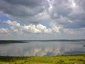 Tiligulsky estuary near the Kalinovka deltadrome | |
| Morphometry | |
| Absolute height | -0.4 [1] m |
| Dimensions | 80 × 2.5 km |
| Square | 170 km² |
| Deepest | 19 m |
| Hydrology | |
| Type of mineralization | bitter salty [1] |
| Pool | |
| Flowing river | Tiligul |
| Location | |
| A country |
|
| Areas | Odessa region , Nikolaev region |
Name Origin
The name of the estuary comes from the Turkic words "Delhi Göl" - Lush Lake. Meanings of the Turkic adjective deli : violent , unpredictable, distraught.
The Turks gave the estuary this name because of strong valley winds blowing mainly from south to north or from north to south along the estuary. It was the unpredictability of local weather that led to this name. The high-altitude wind does not always coincide with the surface wind: in the summer, the sea breeze has a significant effect on local aerology and its effect is sometimes felt at a distance of 25 km from the Black Sea coastline.
History of the Estuary
The Tiligul estuary arose as a result of gradual climate change: gradually evolving from the mouth of a full-flowing river into a semi-closed sea lagoon. At the same time, the salinity of water increased, amounting to more than 30 ppm at the end of 2017. In the old days, the Tiligul River was full-flowing, but over time the climate became arid: less rain fell, the river chalked - began to silt in the lower reaches, and the flow into the sea practically stopped. The construction of a dam and an asphalt road connecting Odessa and Nikolaev regions also had some influence. So the Tiligul embankment arose with a width of about 4 and a length of up to 7 km.
This place is a true paradise for migratory birds and is a nature reserve.
In the middle of the 20th century, an artificial canal was dug connecting the estuary with the Black Sea. The mouth of the channel was constantly silted up and cleared.
A new hydrotechnical project (including a fish-retaining lock structure, protective buns, wall strengthening and a channel deepening) was launched in 2016–2017 with the goal of saving the estuary from drying out. The canal was opened on December 27, 2017 and sea water began to flow into the estuary.
In 1995, the estuary acquired the status of a wetland of international importance and is part of the Tiligulsky regional landscape park. The territory of the Tiligulsky estuary is protected in accordance with the provisions of the Ramsar Convention (Convention on Wetlands).
Geography and nature of the estuary
Tiligulsky estuary is connected to the sea through a canal (from December 27, 2017), which in 2018 it is planned to deepen to 2 m (since it is thanks to this channel that the water level (and salinity) in the estuary should approximately correspond to the Black Sea indicators, and fish could freely migrate from the sea to the estuary. (Since October 27, 2016 the canal was completely blocked for reconstruction). In the driest months, water from the Black Sea enters the estuary , and vice versa - if there is excess runoff to the estuary for several months - “superfluous” water care m into the sea. According to some experts Lyman is the most natural and ecologically clean water basin of Ukraine, because on its banks there is no infrastructure. There is little discharge of sewage and industrial waste water. Some damage has reset the fertilizer on the banks of the estuary fields.
In places of the greatest concentration of people (beaches near gardens), the shores of the Tiligul estuary are polluted with garbage.
In the vicinity of the estuary live pheasants , hares , foxes , wolves . The Strelka estuary located on the estuary of Kosa is a state general zapovednik .
On the banks of the estuary there are several villages: Cordon , Maryanovka, Pshenyanovo , Petrovka , Kalinovka and numerous garden areas (on the western, "Odessa" coast).
Tourism
Tourist and commercial infrastructure on the banks of the estuary exists, but it is limited to horticultural areas, several hunting farms and spontaneous tent towns, so even during the summer season the number of vacationers is relatively small.
Tiligulsky estuary, like many Black Sea estuaries, has large reserves of healing hydrogen sulfide mud. According to some estimates, its reserves here reach 14 million tons. This is the largest known field in the CIS.
In the area of the villages of Kalinovka , as well as Kordon and Pshenyanoye, there are famous deltadromes / paradromes (launching sites for flights on a hang glider and paraglider ). Flights are possible under the following wind directions: C, B, NE, NW and Z. In the area of the village of Kordon (the southern part of the village, near the village of Maryanovka) there is an interesting place for flights under the Northern winds (exclusively C, possible directions of NEW and NER, deviations up to 15 degrees)
The estuary is also suitable for teaching kiting (Chilova Spit of the Tiligul Estuary is the venue for the International Kite Surfing Competition, as well as a favorite place for kite and windsurfers training camps). Chilova Spit is a unique place of its kind, such a wide “flat” is difficult to find elsewhere.
Construction of the Tiligulsky Estuary - Black Sea Canal (2016—2018)
In October 2016, large-scale work began on the restoration of the Tiligul - Black Sea connecting channel, as well as the simultaneous creation of a fish lock gateway infrastructure, protective buns, and a pedestrian-crossing bridge along the seashore.
Estimated length of the channel: 3.5 km. The maximum achievable deepening of the channel: 1.5 m (due to the prevailing depths of the estuary itself at the point of entry into the channel)
In its original form, the canal existed for several decades, in different years the water level in the canal fluctuated significantly and even the direction of the water flow in the canal changed depending on the water level in the estuary, however, the canal was not navigable.
It is assumed that the modern conditional-navigable canal will simultaneously solve several important economic and environmental problems, such as:
1) Prevention of drying out of the estuary;
2) Decrease in salinity of water;
3) Connection by a convenient pedestrian crossing of camp sites of Odessa and Nikolaev regions;
4) Creation and commissioning of fisheries;
5) Possibility of calling small vessels with low draft (Tiligulsky estuary) (tourism, fishing)
In 2018, hydraulic works will continue to strengthen the walls and deepen the Tiligul Canal.
Gallery
Clouds over the tiligul liman
Bank Ranzheva, view from the end point
View of Tiligulsky estuary from Range Spit
Estuary shore
The village of Pshenyanovo . Tiligulsky estuary (view from Range Spit)
The village of Pshenyanovo . Shore of the Tiligul estuary.
Cliffs near the village. Maryanovka
See also
- Tiligul disaster
- Tiligulsky embankment
Notes
- ↑ 1 2 Map sheet L-36-39 Berezanka . Scale: 1: 100,000. Status of the terrain for 1978. 1983 edition
- ↑ 1 2 Tiligulsky estuary // Dictionary of names of hydrographic objects of Russia and other countries - members of the CIS / ed. G.I. Donidze. - M .: Kartgeotsentr - Geodezizdat, 1999 .-- S. 373. - ISBN 5-86066-017-0 .
- ↑ Tyligulskyi Liman . - Information on wetlands on the official website of the Ramsar Convention : ramsar.org (English) (Spanish) (French) . Date of treatment January 26, 2018.
Links
- Official site of the regional landscape park "Tiligulsky" (Nikolaev region) . tiligul.org . Date of treatment March 20, 2019.
- Description of Tiligulsky estuary on Igotoworld: . ua.igotoworld.com . Date of treatment March 20, 2019.
Literature
- Surface water resources of the USSR. Description of rivers and lakes and calculations of the main characteristics of their regime. - T. 6. Ukraine and Moldova. Vol. 1. Western Ukraine and Moldova (without the basin of the Dniester River). - L., Gidrometeoizdat, 1978. - 258-261, 490 p.
- Actual problems of estuaries of the northwestern Black Sea region: Collective monography / ed. Yu.S. Tuchkovenko, E.D. Gopchenko. - Odessa: Odessa State Ecological University, 2011.