Kukolka ( Ukrainian: Kukіlka ) is the left tributary of the Seim River flowing through the Konotop district of the Sumy region of Ukraine .
| Doll | |
|---|---|
| Ukrainian Kukіlka | |
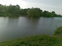 Doll near the village of Shapovalovka Doll near the village of Shapovalovka | |
| Characteristic | |
| Length | 31 km |
| Watercourse | |
| Source | |
| • Location | Shevchenkovskoye village |
| • Coordinates | |
| Mouth | Diet |
| • Location | village of Taranskoye |
| • Coordinates | |
| Location | |
| Water system | Diet → Desna → Dnipro → Black Sea |
| A country |
|
| Region | Sumy region |
| Area | Konotop district |

Geography
Length - 31 km. The riverbed in the middle reaches (the city of Konotop) is located at an altitude of 131.8 m above sea level.
The valley is trough-shaped. The channel is underdeveloped. Used for water supply and fish farming. It has no large tributaries.
The river flows from south to north only in the Konotop district ( Sumy region ), only small sectionsː in the upper reaches from the east turn to the north and the mouth section from the north turns to the west. The river originates west of the village Shevchenkovskoe ( Konotop district ). It flows into the Seim river north of the village of Taranskoye ( Konotop district ).
Two sections of the riverbed are straightened (settled) and channel systems ː between Sosnovka and Popovka, between Virovka and Taranovka adjoin here. There are several large ponds on the riverː between Shevchenkovskoe and Sosnovka. Throughout the length of the river, the floodplain with minor wetlands (the main massif near the village of Popovka) and reed vegetation. On the western outskirts of Konotop, three different railway lines cross the river three times.
In the floodplain of the lower reaches of the river (north of the village of Vrovka), the Seymsky regional landscape park is located .
Settlements
Settlements on the river from source to mouth:
- Konotop district: Shevchenkovskoe , Sosnovka , Shapovalovka , the city of Konotop , Popovka , Vivka , Taran .
Sources
- Puppet // Catalog of Ukraine / comp .: G. І. Shvets , N. І. Drozd , S.P. Levchenko ; Ed .: V. І. Moklyak . - Kyiv : View of the Academy of Sciences of the Ural Soviet Socialist Republic , 1957. - 192 p. - 3000 copies. (Ukrainian)
- Geographic encyclopedia of Ukraine : 3 tons / Editorial: A.M. Marynich et al. - K .: Ukrainian Radyansk encyclopedia, 1989-1993. - ISBN 5-88500-015-8 . (Ukrainian)
- Map sheet M-36-19 Kralevets . Scale: 1: 100,000. State of the terrain for 1986. 1987 edition
- Map sheet M-36-20 Putivl . Scale: 1: 100,000. State of the terrain for 1986. 1987 edition