Khukhra ( Ukrainian: Khukhra ) is the left tributary of the Vorskla River flowing through the Krasnokutsky ( Kharkov region ) and Akhtyrsky ( Sumy region ) regions of Ukraine.
| Khuhra | |
|---|---|
| Ukrainian Khuhra | |
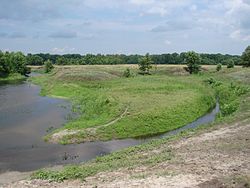 Khuhra at the confluence of Vorskla Khuhra at the confluence of Vorskla | |
| Characteristic | |
| Length | 31 km |
| Watercourse | |
| Source | |
| • Location | Kaplunovka village |
| • Coordinates | |
| Mouth | Vorskla |
| • Location | Khukhra village |
| • Coordinates | |
| Location | |
| Water system | Vorskla → Dnipro → Black Sea |
| A country |
|
| Regions | Kharkov region , Sumy region |
| Areas | Krasnokutsky district , Akhtyrsky district |

Content
Geography
Length - 31 km. The pond near the village of Kaplunovka is located at an altitude of 137.3 m above sea level. The bed is underdeveloped. In dry years, the upper river dries.
The river originates in the forest east of the village of Kaplunovka ( Krasnokutsky district ). The river flows from east to west, first through Krasnokutsky , then Akhtyrsky districts. Several ponds have been created on the riverː in the village of Kaplunovka, between Kaplunovka and Solnechny, in the village of Solnechnoye, in the village of Bugrovatoye, east of the village of Khukhra. In some places, a swampy floodplain ː between Kaplunovka and Solnechny, the mouth area. It falls into the channel Kiselikha of the Vorskla River west of the village of Khukhra ( Akhtyrsky district ).
Settlements
- Settlements on the river from source to mouth:
- Krasnokutsky district: Kaplunovka ;
- Akhtyrsky District: Solnechnoe , Bugrovatoe , Eighth Birch , Peremoga , Khukhra .
Nature
Wetlands and ponds with meadow and reed vegetation. Small groups of trees are sometimes found in the floodplain, only near Kaplunovka there is an oak forest .
On the territory of the Akhtyrsky region, the estuary part of the river is part of the Hetman National Natural Park , and until 2009 - the hydrological reserve of national importance Khukhryansky reserve .
Notes
Sources
- Khukhra // Catalog of Ukraine / state .: G. І. Shvets , N. І. Drozd , S.P. Levchenko ; Ed .: V. І. Moklyak . - Kyiv : View of the Academy of Sciences of the Ural Soviet Socialist Republic , 1957. - 192 p. - 3000 copies. (Ukrainian)
- Geographic encyclopedia of Ukraine : 3 tons / Editorial: A.M. Marynich et al. - K .: Ukrainian Radyansk encyclopedia, 1989-1993. - ISBN 5-88500-015-8 . (Ukrainian)
- Map sheet M-36-70 Akhtyrka . Scale: 1: 100,000. Status of the terrain for 1984. 1985 edition
- Map sheet M-36-49 Kiev is the western part . Scale: 1: 100,000. Status of the terrain in 1991. 1992 edition