The Kurushima-Kaikyo Bridge ( Jap. 来 島 海峡 大 мост ) is a bridge crossing crossing the Kurushima-Kaikyo Strait between the islands of Shikoku and Oshima (the Inland Sea ), located in the northern part of the city of Imabari . It is part of the 317 highway ( Onomichi - Imabari ) and the system of bridges Honshu-Shikoku .
| Kurusima-Kaikyo Bridge | |
|---|---|
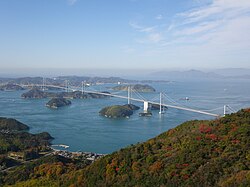 View from Mount on Oshima Island Islands at the bridge (by distance): , Nikatojima ( 中 渡 島 ), | |
| Official name | jap. 来 島 海峡 大橋 |
| Application area | car, pedestrian |
| Crosses | the strait of Kurushima-Kaikyo between the islands of Shikoku and Oshima |
| Location | Ehime , Imabari Shikoku - Oshima |
| Design | |
| Type of construction | hanging |
| Material | |
| Main span | 1030 m [1] |
| total length | 4045 m |
| Bridge width | 27 m |
| Exploitation | |
| Start of construction | May 15, 1988 |
| Opening | May 1, 1999 |
Feature
On May 1, 1999, the Kurushima-Kaikyo Bridge was opened to traffic on the expressway linking the town of Imabari on the island of Shikoku (Kouratyo, Chikamitö, Nakabori districts) and the island of Oshima ( district ).
The length is 4045 m (960 + 1515 + 1570 [2] ). The bridge is represented by three hanging bridges: First Kurushima-Kaikyo , Second Kurushima-Kaikyo and Third Kurushima-Kaikyo . The bridge crosses the small islands of and . The bridge has six towers and four bearing piers. It is the longest bridge crossing among the hanging bridges in the world, overtaking Akashi-Kaikyo by 104 m. The length of the main span: the First bridge is 600 m, the Second is 1020 m, and the Third is 1030 m.
It has 4 rows of traffic for cars (two on both sides), 2 rows for motorcycles, walking paths.
See also
- Tatara Bridge
Notes
- ↑ Third Bridge.
- ↑ First + Second + Third
Links
- Kurushima-Kaikyō Bridge home page
- Honshū-Shikoku Bridge Authority home page
- First Kurushima Kaikyo Bridge on Structurae website
- Second Kurushima Kaikyo Bridge on Structurae
- Third Kurushima Kaikyo Bridge on Structurae