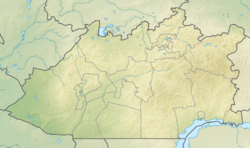
Atasu is a river in the Karaganda region , the left tributary of the Sarysu river. It flows through the territories of Zhanaarka district . Length 177 km, basin area 5920 km².
| Atasu | |
|---|---|
| Characteristic | |
| Length | 177 km |
| Swimming pool | 5920 km² |
| Water consumption | 0.66 m³ / s |
| Watercourse | |
| Source | |
| • Location | on the slopes of the Kyzyltu mountains, Uzinzhal |
| Mouth | Sarysu |
| • Coordinates | |
| Location | |
| A country |
|
| Region | Karaganda region |
Snow food. High water - in the spring. Dries in the summer. The average annual water flow rate is 0.66 m³ / s.
It starts on the slopes of the Kyzyltu mountains, Uzynzhal.
Tributaries: Bylkildak, Karakog, Karkymbay, Isabek Karasuy, Boranbai. The Kylysh reservoir (near the city of Karazhal ) was built at Atasu.
Literature
- Atasu (river) // Kazakhstan. National Encyclopedia . - Almaty: Kazakh encyclopedias , 2004. - T. I. - ISBN 9965-9389-9-7 .
When writing this article, material from the publication Kazakhstan. National Encyclopedia ”(1998-2007), provided by the editors of the“ Kazakh Encyclopedia ”under a Creative Commons BY-SA 3.0 Unported license .