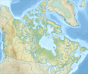
Queen Elizabeth Islands ( Queenles de la Reine-Élisabeth ; formerly known as the Parry Islands or Parry Archipelago ) is the northernmost segment of the Canadian Arctic Archipelago , divided between Nunavut and the Northwest Territories in northern Canada .
| Queen Elizabeth Islands | |
|---|---|
| English Queen Elizabeth Islands , fr. Îles de la Reine-Élisabeth | |
 | |
| Characteristics | |
| Number of islands | 2126 |
| Largest island | Ellesmere |
| total area | 419,061 km² |
| Highest point | 2616 m |
| Population | 375 people (2006) |
| Population density | 0 people / km² |
| Location | |
| Water area | Arctic Ocean |
| A country |
|
| Provinces | Nunavut , Northwest Territories |
Content
Geography
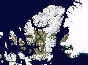
The islands lie in the Arctic Ocean basin north of the McClure , Wycomecount – Melville , Barrow , and Lancaster straits (in English sources these four straits are called Parry Channal (Parry Strait)). The shape of the island is a triangle, at the top of which lies Ellesmere Island , and the islands are Prince Patrick , Melville , Bathurst , Cornwallis , Devon [1] .
Nunavut Northwest Territories Quebec Greenland
After renaming, the term Parry Archipelago continues to be used for the southwestern part of the archipelago ( Prince Patrick , Melville , Bathurst , Borden , Mackenzie King , Cornwallis and the small islands surrounding them) [2] , part of other islands ( Amund Ringes , Axel- Kheiberg , Ellef Ringnes , Cornwall ) belong to the group of Sverdrup islands [3] .
Some islands have a low relief, others are flat plateaus 300-600 meters high, mountain ranges up to 1921 meters high rise on Devon Island, the largest island of the archipelago is Ellesmere, on which Barbo Peak (2616 meters) is located - the highest peak of Ellesmere Island, the archipelago and the territory of Nunavut. The climate of the islands is extremely harsh, arctic. The islands are covered by polar deserts.
The total area of the islands is 419,061 km² [4] . Many of the islands are among the largest on the globe , the largest of them is Ellesmere , another large island is Devon .
| No. | Isle | Subgroup | Territory | Area, km² | A place In Canada | A place in the world | Coordinates |
|---|---|---|---|---|---|---|---|
| one | Alexander [5] | Parry Archipelago | Nunavut | 484 | 66 | ||
| 2 | Amund Ringnes [6] | Sverdrup | Nunavut | 5255 | 25 | 111 | |
| 3 | Axel Heyberg [7] | Sverdrup | Nunavut | 43178 | 7 | 32 | |
| four | Bailey Hamilton [8] | Parry Archipelago | Nunavut | 290 | 91 | ||
| 5 | Bathurst [9] | Parry Archipelago | Nunavut | 16042 | 13 | 54 | |
| 6 | Borden [10] | Parry Archipelago | Nunavut / Northwest Territories | 2794 | thirty | 170 | |
| 7 | Brock [11] | Parry Archipelago | Northwest Territories | 764 | 58 | 383 | |
| 8 | Buckingham Island [12] | Parry Archipelago | Nunavut | 137 | 137 | ||
| 9 | Byam Martin [13] | Parry Archipelago | Nunavut | 1150 | 42 | 294 | |
| 10 | Cameron [14] | Parry Archipelago | Nunavut | 1059 | 46 | 312 | |
| eleven | Koberg [15] | Parry Archipelago | Nunavut | 411 | 83 | ||
| 12 | Cornwall [16] | Sverdrup | Nunavut | 2358 | 31 | 184 | |
| 13 | Cornwallis [17] | Parry Archipelago | Nunavut | 6995 | 21 | 96 | |
| fourteen | Devon [18] | Parry Archipelago | Nunavut | 55247 | 6 | 27 | |
| fifteen | Eglinton [19] | Parry Archipelago | Northwest Territories | 1541 | 36 | 249 | |
| 16 | Ellef Ringnes [20] | Sverdrup | Nunavut | 11295 | 16 | 69 | |
| 17 | Ellesmere [21] | Nunavut | 196236 | 3 | 10 | ||
| eighteen | Emerald [22] | Parry Archipelago | Northwest Territories | 549 | 63 | 466 | |
| 19 | Graham [23] | Sverdrup | Nunavut | 1378 | 38 | 265 | |
| twenty | Griffith [24] | Parry Archipelago | Nunavut | 189 | 110 | ||
| 21 | Helena [25] | Parry Archipelago | Nunavut | 327 | 85 | ||
| 22 | Hoved [26] | Parry Archipelago | Nunavut | 158 | 125 | ||
| 23 | Wannier [27] | Parry Archipelago | Nunavut | 1126 | 44 | 298 | |
| 24 | King Christian [28] | Sverdrup | Nunavut | 645 | 60 | 420 | |
| 25 | Little Cornwallis [29] | Parry Archipelago | Nunavut | 412 | 75 | ||
| 26 | Lochid [30] | Parry Archipelago | Nunavut | 1308 | 41 | 273 | |
| 27 | Lawther [31] | Parry Archipelago | Nunavut | 145 | 133 | ||
| 28 | Mackenzie King [32] | Parry Archipelago | Nunavut / Northwest Territories | 5048 | 26 | 115 | |
| 29th | Massey [33] | Parry Archipelago | Nunavut | 432 | 71 | ||
| thirty | Mien [34] | Sverdrup | Nunavut | 955 | fifty | 337 | |
| 31 | Melville [35] | Parry Archipelago | Nunavut / Northwest Territories | 42149 | 8 | 33 | |
| 32 | North Kent [36] | Parry Archipelago | Nunavut | 590 | 62 | 453 | |
| 33 | Prince Patrick [37] | Parry Archipelago | Northwest Territories | 15848 | fourteen | 55 | |
| 34 | Store [38] | Sverdrup | Nunavut | 313 | 87 | ||
| 35 | Other small islands [4] (2,092 units) | Nunavut / Northwest Territories | 2321 | ... | ... | ... | |
| Queen Elizabeth Islands [4] | Nunavut / Northwest Territories | 419061 | ... | ... |
History
For the first time, Europeans discovered the islands in 1616 . The name was given by the British Admiralty in honor of the British Arctic explorer W.E. Parry , who discovered the archipelago in 1819-1820. The islands are then named after Elizabeth II after her coronation as Queen of Canada in 1953 .
Population
The population is 375 people (2006). The most significant settlements are the village of Resolute on the island of Cornwallis (229 people) and the Gris Fjord on Ellesmere (141 people). Alert is also located on Ellesmere - the northernmost settlement in the world (5 people). The remaining islands do not have a permanent population. The main economic activity is oil drilling.
See also
- Canadian Arctic Archipelago
- Queen Elizabeth's Land
Notes
- ↑ Canadian Encyclopedia. The queen elizabeth islands
- ↑ Parry Archipelago
- ↑ Sverdrup Island - article from the Great Soviet Encyclopedia .
- ↑ 1 2 3 Sea islands: (inaccessible link) . Date of treatment April 3, 2007. Archived January 22, 2013. Atlas of Canada ; Natural resources canada
- ↑ Alexander Island . Date of treatment December 23, 2010. Archived December 23, 2010. at oceandots.com
- ↑ Amund Ringnes Island . Date of treatment May 28, 2008. Archived December 23, 2010. at oceandots.com
- ↑ Axel Heiberg Island . Date of treatment December 23, 2010. Archived December 23, 2010. at oceandots.com
- ↑ Baillie-Hamilton Island . Date of treatment May 6, 2008. Archived December 23, 2010. at oceandots.com
- ↑ Bathurst Island at Bivouac.com
- ↑ Borden Island . Date of treatment December 23, 2010. Archived December 23, 2010. at oceandots.com
- ↑ Brock Island . Date of treatment December 23, 2010. Archived December 23, 2010. at oceandots.com
- ↑ Buckingham Island at the Atlas of Canada
- ↑ Byam Martin Island . Date of treatment March 14, 2009. Archived December 23, 2010. at oceandots.com
- ↑ Cameron Island . Date of treatment August 17, 2009. Archived December 23, 2010. at oceandots.com
- ↑ Coburg Island . Date of treatment August 20, 2009. Archived December 23, 2010. at oceandots.com
- ↑ Cornwall Island . Date of treatment August 17, 2009. Archived December 23, 2010. at oceandots.com
- ↑ Cornwallis Island . Date of treatment August 17, 2009. Archived December 23, 2010. at oceandots.com
- ↑ Devon Island . Date of treatment June 26, 2008. Archived December 23, 2010. at oceandots.com
- ↑ Eglinton Island . Date of treatment August 17, 2009. Archived December 23, 2010. at oceandots.com
- ↑ Ellef Ringnes Island . Date of treatment August 17, 2009. Archived December 23, 2010. at oceandots.com
- ↑ Ellesmere Island . Date of treatment January 15, 2009. Archived December 23, 2010. at oceandots.com
- ↑ Emerald Isle . Date of treatment August 17, 2009. Archived December 23, 2010. at oceandots.com
- ↑ Graham Island . Date of treatment April 10, 2008. Archived December 23, 2010. at oceandots.com
- ↑ Griffith Island at the Atlas of Canada
- ↑ Helena Island . Date of treatment August 20, 2009. Archived December 23, 2010. at oceandots.com
- ↑ Hoved Island at the Atlas of Canada
- ↑ Île Vanier . Date of treatment August 17, 2009. Archived December 23, 2010. at oceandots.com
- ↑ King Christian Island . Date of treatment May 12, 2008. Archived December 23, 2010. at oceandots.com
- ↑ Little Cornwallis Island . Date of treatment August 20, 2009. Archived December 23, 2010. at oceandots.com
- ↑ Lougheed Island . Date of treatment August 17, 2009. Archived December 23, 2010. at oceandots.com
- ↑ Lowther Island at the Atlas of Canada
- ↑ Mackenzie King Island . Date of treatment August 17, 2009. Archived December 23, 2010. at oceandots.com
- ↑ Massey Island . Date of treatment August 17, 2009. Archived December 23, 2010. at oceandots.com
- ↑ Meighen Island at arctic.uoguelph.ca
- ↑ Melville Island . Date of treatment August 17, 2009. Archived December 23, 2010. at oceandots.com
- ↑ North Kent Island . Date of treatment August 17, 2009. Archived December 23, 2010. at oceandots.com
- ↑ Prince Patrick Island at peakbagger.com
- ↑ Stor Island . Date of treatment April 13, 2008. Archived December 23, 2010. at oceandots.com
Links
- Atlas of Canada; natural resources of Canada (inaccessible link) . Date of treatment April 3, 2007. Archived January 22, 2013.
- Parry Archipelago at TSB