Dzhiltemesay ( Uzbek Jiltemasoy / Zhiltemasoy ) is a mountain river (sai [com 1] ) in the Nurata district of the Navoi region , the left tributary of the Say Kalamdzhar (it is currently drying up before reaching it). In the lower reaches it is called Chuyasay ( Uzbek. Chuyaasoy / Chuyasoy ).
| Giltemesay | |
|---|---|
| Uzbek Jiltemasoy | |
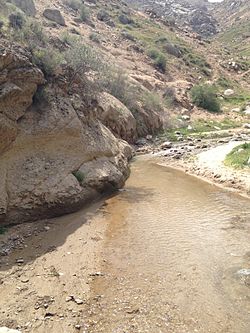 Giltemesay upstream in May Giltemesay upstream in May | |
| Characteristic | |
| Length | 18 km |
| Pool | 25 km² |
| Water consumption | 0,080—0,100 m³ / s |
| Watercourse | |
| Source | |
| • Location | Aktau ridge, Lyangar village |
| • Height [?] | about 1300-1500 m |
| • Coordinates | |
| The mouth [?] | blind (does not reach Saya Kalamjar ) |
| • Location | Nurata Plain , 3 km south-west of the village of Saykichar |
| • Height | about 650 m |
| • Coordinates | |
| Location | |
| Water system | Kalamjar |
| A country |
|
| Region | Navoi region |

General Description
The length of the Giltemesaya is 18 km, the basin area is 25 km² [1] .
The average annual flow rate is 80-100 l / s. At the same time, the full-flowing capacity of sai increases from February to April, and in May, and especially in June, decreases. River food is mixed: first of all, rain, partly snow and spring. Due to the large number of springs in the basin, the watercourse in the upper and middle reaches does not dry out completely throughout the year [1] .
River
Giltemesay is formed on the northern slope of the Aktau ridge, at the northern edge of the village of Lyangar [1] [2] at an altitude of about 1300-1500 m [2] . It flows in a general northeastern direction, in some sections - approximately to the east [2] [3] . The river basin from the northeast is limited by the Koshdergen mountain range [2] .
In the course of the sai, the inhabited villages of Karatut , Dara , Chuya are located . Behind the settlement, Dara [3] merges with a large tributary of Kirichsai , takes on the name Chuyasai and leaves the mountains on the Nurata Plain [1] . In the Chuya region, the water in the river runs out (the Chuyaaryk canal leaves from it), then it continues as a dry channel. Below sai crosses the R-55 highway [3] .
Giltemesay is considered a tributary of the Kalamjar Sai, but does not reach it [1] even as a dry riverbed. The Chuyasaya channel disappears at the Saparniyazkuduk [3] well 3 km south-west of the Saykichar [1] village , located on the bank of Kalamjar. The end point is at an altitude of about 650 m [3] .
Gilthemes tributaries
A tributary of Giltemesai is Kirichsai , flowing to the left, behind the settlement of Dara [1] [3] .
Notes
- Comments
- ↑ Sayas in Central Asia are called ravines with permanent or temporary watercourses, as well as the watercourses themselves (in particular, relatively small rivers experiencing sharp seasonal fluctuations in full flow or are completely dry).
- Sources
- ↑ 1 2 3 4 5 6 7 Giltemasoy - National Encyclopedia of Uzbekistan . - Tashkent, 2000-2005. ( Uzbek )
- ↑ 1 2 3 4 Map sheet K-41-132 Nurata . Scale: 1: 100,000. State of the terrain for 1983. 1989 Edition
- ↑ 1 2 3 4 5 6 Map sheet K-42-121 Jush . Scale: 1: 100,000. State of the terrain for 1983. 1987 edition
Literature
- Zhiltemasoy - National Encyclopedia of Uzbekistan . - Tashkent, 2000-2005. ( Uzbek )