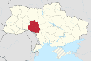
Vinnytsia region ( Ukrainian: Vinnytska oblast ) is a region in Ukraine . The administrative center of the region is the city of Vinnitsa .
| region | |||||
| Vinnytsia region | |||||
|---|---|---|---|---|---|
| Ukrainian Vinnytska region | |||||
| |||||
| A country | |||||
| Includes | 27 districts, 18 cities, 29 urban settlements, 1466 villages | ||||
| Adm. center | Vinnitsa | ||||
| Chairman of the regional state administration | Vladislav Vladimirovich Skalsky [1] | ||||
| Chairman of the Regional Council | Anatoly Dmitrievich Oleinik | ||||
| History and Geography | |||||
| Date of formation | February 27, 1932 | ||||
| Area | 26 492 [2] km² (4.39%, 12th place ) | ||||
Height
|
| ||||
| Timezone | EET ( UTC + 2 , summer UTC + 3 ) | ||||
| The largest city | Vinnitsa | ||||
| Dr. big cities | Zhmerynka , Mogilev-Podolsky , Khmelnik | ||||
| Population | |||||
| Population | 1548585 [3] people ( 2019 ) | ||||
| Density | 61.07 people / km² | ||||
| Nationalities | Ukrainians, Russians, Poles. | ||||
| Official language | Ukrainian | ||||
| Digital identifiers | |||||
| ISO 3166-2 Code | UA-05 | ||||
| Telephone code | +380 43 | ||||
| Postal codes | 21xxx, 22xxx, 23xxx, 24xxx | ||||
| Internet domain | .vinnica.ua, .vn.ua | ||||
| Auto Code numbers | Ab | ||||
| Official site | |||||
 | |||||
 | |||||

Vinnytsia region was formed on February 27, 1932 . Historically, the region was preceded by part of the counties of the Podolsk province .
Content
- 1 Physical and geographical characteristic
- 1.1 Geographical location
- 1.2 Relief
- 1.3 Climate
- 1.4 Soil
- 1.5 Vegetation
- 2 History
- 3 population
- 4 Administrative-territorial structure
- 4.1 Administrative division
- 4.2 Change in administrative divisions
- 4.3 Authorities
- 4.4 Neighborhoods
- 4.5 Cities
- 5 General map
- 6 Economics
- 6.1 Major industries
- 6.2 Mechanical Engineering
- 6.3 Building materials industry
- 6.4 Economic performance
- 7 Transport
- 8 Resort Resources
- 9 Born in the Vinnitsa region
- 10 Attractions
- 11 Notes
- 12 Literature
- 13 Links
Physico-geographical characteristics
Geographical position
Vinnytsia region is located on the Right-Bank Ukraine, in the eastern part of Podillia . In the north, the region borders on the Zhytomyr region, in the east - with the Kiev , Cherkasy and Kirovograd regions, in the west - with the Khmelnytsky and Chernivtsi regions, in the south - with the Odessa region and Moldova .
Relief
Most of the region’s territory is located within the Podolsk (elevation up to 362 m) and Dnieper (elevation up to 323 m) hills. The surface of the Vinnitsa region is a wavy plain, rising to the northwest and decreasing to the south and southeast. Its southwestern part is particularly strongly dissected by the narrow valleys of the meridional left tributaries of the Dniester .
Climate
The climate is temperate continental . Winter is moderately mild. The average temperature of the coldest month (January) is from −4 ° C to −6 ° C (−5.7 ° C, Vinnitsa ). Summer is warm, sunny; Wed temperature of the warmest (July) approx. 18 ° C. Precipitation is 500-550 mm per year, mainly in summer (during the warm period - 375-400 mm). The number of hours of sunshine is up to 1850 per year. The duration of the growing season (with temperatures above 10 ° C) is about 180-200 days.
In the central part of the region, the South Bug River flows from the north-west to the southeast with the tributaries Zgar , Rov , Selnitsa, Dohna, Snivoda, Desna , Sob , Udych, along the south-western border of the region the Dniester River flows with the left tributaries: Lyadova , Kamenka , Nemia, Murafa and others. Rivers are used for small shipping and as sources of hydropower.
Soil
Fertile soils prevail in the Vinnitsa region. In the northeastern part of the region, mainly black earth soils are distributed, in the central - gray and light gray, in the southeast and in the Transnistrian regions - alternation of thick chernozems with podzolized soils.
Vegetation
Vinnytsia region is located in the forest-steppe zone. Oak , hornbeam , ash , linden , maple , and pine grow in the forests.
Forests and shrubs occupy 12.6% of the territory of the region, treeless spaces are plowed up.
Fauna: roe deer , wolf , fox , marten , squirrel , hare ; along the banks of rivers and other bodies of water - minks , otters , ducks , geese .
History
The mammoth tusk found in the village of Doroshivka over 22 thousand years old has the oldest image of a deer in Ukraine [4] [5] .
Objects of Trypillian culture (IV — III millennium BC), Poenesti-Lukashev culture (III — IV century AD) and Prague culture (V — VII century AD) were studied in the village of Bernashovka [6] .
Nemirovskoe settlement - a multi-layered monument of archeology of the Scythian time.
In the IX century, the Slavic tribes of streets , Buzhan and Tiverts , who were part of the ancient Russian state - Kievan Rus, lived on the lands of the present Vinnitsa region. Over time, this region was annexed to the Galicia-Volyn principality . The territory of the region was devastated during the Mongol-Tatar invasion of 1237-1240. After the victory in 1362 of the army of the Lithuanian prince Olgerd over the army of the Mongol-Tatars in the battle on the Blue Waters, Podillia fell under the rule of the Lithuanian principality . Since 1569, the territory of the region was part of Poland . In the Buchach peace of 1672, Poland gave the Turks a significant part of the Podolsky , Bratslav, and Kiev voivodships, but in 1686 they returned these lands.
In the XVII century - the beginning of the XVIII century, Cossack regiments were located in the Vinnitsa region: Vinnitsa (Kalnitsky) regiment with centers in Vinnitsa and Kalnik, Bratslav regiment with a center in Bratslav, Podolsky regiment with a center in Mogilev-Podolsky, Chechelnitsky regiment with a center in Chechelnik, Zhivotovsky regiment with its center in Zhivotov , as well as hundreds of Cossack (in particular, Bershad and Ladyzhinsky) of the Umansky regiment and Pavolochsky regiment .
As a result of the second partition of Poland in 1793, the territory of the region became part of the Russian Empire . April 13, 1793 was established Bratslav province from Podolsk and Bratslav voivodships. On the basis of tsar's decrees of May 22, 1795, Bratslav governorship was created, divided into 13 districts. Having ascended the throne, Paul I by decree of December 12, 1796 liquidated Bratslav governorship , and its lands became part of Podolsky (Bratslav, Vinnitsa, Litinsky, Bershad, Gaysinsky, Yampolsky, Mogilevsky, Tulchinsky and Khmelnitsky counties) and Kiev province (Makhnovsky, Skvvsky, Skvvsky, Skvvsky, Skvvsky , Lipovetsky and Pyatigorsk counties).
During the formation of the Podolsk province in 1796, the territory of the region became part of it as the Vinnitsa district .
During the civil war of 1917-1920, power in the cities and villages of the future Vinnitsa region repeatedly changed, and at the end of the war the territory of the region became part of the Ukrainian SSR .
Vinnytsia region was formed on February 27, 1932, among the first five regions of the Ukrainian SSR . September 22, 1937 from the region was allocated Kamenetz-Podolsk region .
In 1941, during the Great Patriotic War, the territory of the Vinnitsa region was captured by German troops, near the Vinnitsa was built the Werewolf bunker - Hitler’s headquarters. In 1944, the Vinnytsia region was liberated by the Red Army .
In the post-war years, the region was actively recovering and soon became the leader of the beet-growing and sugar industry of the USSR. The region was also distinguished by vegetable growing, horticulture and animal husbandry [7] .
After the collapse of the USSR in December 1991, it is part of independent Ukraine .
Population
The population of the region according to Ukrstat is 1,575,000 [8] people. (2017).
As of December 5, 2001 (Ukrainian census), the population of the Vinnitsa region was 1,772,400 people, of which 818,900 - live in cities, 953,500 - in villages. The population of the region as of December 1, 2013 amounted to 1,619,253 people (which is 1,090 less than November 1), including the urban population of 815,423 people (50.36%), the rural population - 803,830 people (49, 64%). The permanent population is 1,612,168 people. Including the urban population — 806,417 people (50.02%), and the rural population — 805,751 people (49.98%). The number of rural population is the largest after the Lviv region among the regions of Ukraine. Representatives of 92 nationalities live in the region, among which 93.5% are Ukrainians , 3.9% are Russians , 1.4% are Jews , 0.4% are Poles , 0.26% are Belarusians , 0.2% are Moldovans .
The largest cities in the region are Vinnitsa (371 100), Zhmerynka (35.4 thousand), Mogilev-Podolsky (32.2 thousand), Khmelnik (28.2 thousand), Kazatin (24.3 thousand), Gaysin (25.7 thousand ), Ladyzhin (22.9 thousand), Kalinovka (19.3 thousand), Bar (16.4 thousand).
According to professional structuring, among the employed population there are 326,400 workers in agriculture, forestry and fisheries, 127,500 in industry, 105,900 in services and trade, 59.0 thousand in education, 51.1 thousand in healthcare and social assistance. , 44.7 thousand - in the field of transport and communications.
The first secretaries of the regional committee [9] :
| No. | Name | Period | Comment |
|---|---|---|---|
| one | Alekseev, Nikita Alekseevich | 02/32/32 - 10/1932 | |
| 2 | Chernyavsky, Vladimir Ilyich | 10.1932–08.1937 | |
| 3 | Bondarenko, Mikhail Ilyich | 08/08/37 - 08/30/1937 | and. about. |
| four | Spivak, Illarion Savelyevich | 09.1937-1938 | |
| 5 | Mishchenko, Gavriil Korneevich | 1938-10.1941 | |
| 6 | Korneychuk, Mikhail Sergeevich | 1941-1944 | underground |
| 7 | Mishchenko, Gavriil Korneevich | 03/03/44—07/1945 | |
| 8 | Stakhursky, Mikhail Mikhailovich | 07/07/45—1951 | |
| 9 | Shevchuk, Grigory Ivanovich | 1951-11.1952 | |
| 10 | Bubnovsky, Nikita Dmitrievich | 11.1952—03.1954 | |
| eleven | Doroshenko, Petro Emelyanovich | 03.1954 - 08.22.1955 | |
| 12 | Trump, Pavel Panteleevich | 08/22/1955—01.1963 | |
| 13 | Trump, Pavel Panteleevich | 01.1963-12.1964 | rural |
| fourteen | Shevtsov, Yuri Nikolaevich | 01.1963-12.1964 | industrial |
| fifteen | Trump, Pavel Panteleevich | 12.1964-7.05.1970 | |
| 16 | Taratuta, Vasily Nikolaevich | 05/07/1970—03.1983 | |
| 17 | Krivoruchko, Leonty Leontyevich | 03.1983-11.1988 | |
| eighteen | Nekhaevsky, Arkady Petrovich | 11.1988—26.08.1991 |
Administrative-territorial structure
Administrative division
For the implementation of public administration functions, the Vinnytsia region is divided into:
- areas (27)
- cities of regional subordination (6)
Change of administrative division
- 02/27/1932 - Vinnitsa region was formed consisting of 69 districts and 2 cities of regional subordination.
- 10/15/1932 - Babansky, Monastyryshchensky, Oratovsky, Plykivsky, Pogrebischensky, Umansky and Khristinovsky districts are transferred to the Kiev region.
- 03/07/1933 - Yurinetsky district was renamed Satanovsky.
- 12/01/1933 - in the region of 64 districts.
- 04/01/1935 - 4 districts were created.
- 01.01.1937 - 44 districts and 4 districts (74 districts in total): Barsky, Bershad, Bratslavsky, Vinnitsa, Vovkovinetskoy, Voronovitsky, Gaysinsky, Dashevsky, Derazhnyansky, Dzhulinsky, Zhmerinsky, Zatonsky, Ilyinsky named after Dzerzhinsky, Kalinovsky, Kazatinsky, Nemirovib Obodovsky, Olgopolsky, Ostropilsky, Peschansky, Sitkovetsky, Shpikovsky, Yanushpilsky districts; Kamyanets-Podilsky (Dunaevetsky, Minkovetsky, Novoushitsky, Oryninsky, Smotrytsky, Solobkovetsky, Staroushitsky and Chemerovetsky Yarishivsky Mikhalpilsky, Satanovsky, Chernoostrovsky, Yarmolinetsky districts), Shepetovsky (Antoninsky, Berezdov district).
- September 22, 1937 - 33 districts were transferred to the Kamenetz-Podolsky region (Vinkovetsky (Zatonsky), Vovkovinetsky, Derazhnyansky, Letichevsky, Medzhibozhsky, districts of the Kamenetz-Podolsky, Proskurovsky and Shepetovsky districts), 4 - to the Zhytomyr (Dzerzhinsky, Lyubarsky, Chudsky, Yudpilsky, Chudsky, Judy ) In the region there are 37 districts; 4 districts moved from the Kiev region: Monastyryshchensky, Oratovsky, Pliskovsky, Pogrebischensky.
- 1946 - the Dzhurinsky district was created.
- On June 4, 1958, the Mogilev-Podolsky district was formed (a total of 45 districts).
- 1954 - The monastery district moved to the Cherkasy region.
- 1950s - 12 districts were abolished: Voronovitsky, Dashevsky (01.21.1959), Dzhulinsky, Dzhurinsky, Kopaygorodsky, Obodovsky (01.21.1959), Olgopolsky, Samgorodsky, Sitkovetsky (01.21.1959), Stanislavchitsky, Turbovsky, Yampolsky.
- 1962 - enlargement of districts (13 were created instead of 32): Barsky, Bershad, Gaysinsky, Zhmerinsky, Kalinovsky, Koziatinsky, Kryzhopolsky, Lipovetsky, Mogilev - Podolsky, Nemirovsky, Pogrebischensky, Tulchinsky, Khmelnitsky.
- January 4, 1965 - Vinnitsa, Ilyinets, Tyvrov, Trostyanets, Shargorod and Yampol districts were restored.
- 1966 - Litinsky, Murovanokurilovetsky, Peschansky, Teplitsky, Tomashpolsky, Chechelnitsky districts were restored.
- 1979 - Oratovsky district was restored.
- November 28, 1990 - Chernevets district was created.
Authorities
State authorities of the Vinnitsa region are located in Vinnitsa.
Government bodies and officials of the Vinnitsa region are:
- Vinnytsia Regional Council - legislative (representative) body of state power; the term of office of deputies is 4 years. It is elected by the population of the region (one half of the composition - according to party lists, the other - according to single-mandate constituencies), the current composition was formed in 2010. The building of the Duma is located in Vinnitsa.
- The governor of the Vinnitsa region is the highest official in the region.
Neighborhoods
In the Vinnitsa region 27 districts:
- Barsky district
- Bershad district
- Vinnitsa district
- Gaysinsky District
- Zhmerinsky district
- Ilyinetsky district
- Kalinovsky district
- Kazatinsky district
- Kryzhopolsky district
- Lipovetsky district
- Litinsky district
- Mogilev-Podolsky district
- Murovanokurilovets district
- Nemirovsky district
- Oratovsky district
- Peschan district
- Pogrebischensky district
- Teplik district
- Tomashpolsky district
- Trostyanetsky district
- Tulchinsky district
- Tyvrovsky district
- Khmelnitsky district
- Chernevets district
- Chechelnitsky district
- Shargorodsky district
- Yampolsky district
Cities
Cities of regional significance:
- Vinnitsa
- Mogilev-Podolsky
- Kazatin
- Ladyzhin
- Zhmerynka
- Khmilnik
Cities of district significance:
- Bar
- Bershad
- Gaysin
- Rotting
- Ilyintsy
- Kalinovka
- Lipovets
- Nemirov
- Cemetery
- Tulchin
- Shargorod
- Yampol
| Settlements with a population of over 8 thousand as of January 1, 2015 [10] | ||||||||||||||||||||||||||||||||||||||||
|
Community Map
Map Legend:
| The regional center, more than 300,000 people. | |
| from 25,000 to 50,000 people | |
| from 10,000 to 25,000 people | |
| from 5,000 to 10,000 people. | |
| from 2,000 to 5,000 |
Economics
Экономика региона в большинстве ориентирована на аграрный сектор и обрабатывающую промышленность. Все ведущие отрасли (за исключением электроэнергии) непосредственно связаны с производством сельхозпродукции, начиная с производства машин и удобрений и заканчивая переработкой сельскохозяйственного сырья. Крупнейшие промышленные предприятия области — радиотехнический, ликёроводочный заводы, завод Кристалл, ЗАО Химпром и масложировый комбинат в городе Винница, машиностроительные заводы им. Кирова в городе Могилёв-Подольский и в городе Бар. На область приходится 12,7 % численности промышленно-производственного потенциала Украины, 2 % стоимости основных производственных фондов и 2,6 % выпуска промышленной продукции.
Выделяют такие главные отрасли промышленности Винницкой области как: пищевая промышленность, машиностроение, легкая промышленность, производство стройматериалов.
Аграрным производством в области занимается более 700 коллективных сельскохозяйственных и межхозяйственных предприятий, более 100 совхозов, 846 сельских (фермерских) и 333 подсобных и заготовительных хозяйств, 4 исследовательских станции, научно-исследовательский институт кормов. На Винниччине есть предприятия по переработке семян подсолнечника, крупяных культур. Винниччина занимает 1 место в стране по валовому производству сахара и зерна.
В недрах области найдено более 1100 месторождений и залежей 30 видов различных полезных ископаемых, десятки месторождений торфа, а также залежи гранита и каолина, граната и флюорита. В области действует ряд источников минеральной, а также радоновой воды в городе Хмельник.
Индустриальный потенциал области сконцентрирован в предприятиях — Ладыжинская ГРЭС, объединений «Октябрь», «Инфракон», «Маяк», «Кристалл», «Винницкий подшипниковый завод», «Химпром», десятки предприятий перерабатывающей и легкой промышленности. В разных областях промышленности в области работает около 400 предприятий.
Главные отрасли промышленности
В отраслевой структуре промышленности Винницкой области выделяются пищевая промышленность, машиностроение, легкая промышленность, производство стройматериалов, электротехническая и радиотехническая промышленность, сельскохозяйственное машиностроение, а также приборостроение.
Машиностроение
Довольно большую группу промышленных предприятий области составляют предприятия:
- Винницкий завод тракторных агрегатов, производящий узлы и запасные части к тракторам и комбайнам;
- Калиновский машиностроительный завод, который производит оборудование для сахарных заводов;
- Могилев-Подольский и Барский машиностроительные заводы.
Промышленность строительных материалов
В данной отрасли основное место занимает каолиновое производство (Глуховецкий и Турбовский комбинаты), а также добыча гранита (Гниваньский, Жежелевский, Губниковский гранитные карьеры). Важнейшими центрами строительной индустрии являются следующие города: Винница, Гнивань, Глуховцы, Ладыжин, Немиров, Погребище.
Экономические показатели
| N | показатель | единицы | значение, 2014 year |
|---|---|---|---|
| one | Экспорт товаров | млн долларов США | 742,2 [11] |
| 2 | Уд.вес в общеукраинском | % | 1.4 |
| 3 | Импорт товаров | млн долларов США | 428,2 [11] |
| four | Уд.вес в общеукраинском | % | 0.8 |
| 5 | Сальдо экспорт - импорт | млн долларов США | 314,0 [11] |
| 6 | Капитальные инвестиции | млн гривен | 5490,9 [12] |
| 7 | Средняя зарплата | UAH | 2810 [13] |
| 8 | Средняя зарплата [14] | долларов США | 236,4 [15] |
По материалам Комитета статистики Украины (укр.) и Главного управления статистики в Винницкой области (укр.)
Transport
Винницкая область имеет весьма обширную транспортную сеть, включающую автомобильные и железные дороги, водные пути по крупнейшим рекам. Структура наземных линий представляет собой ряд магистралей. Крупными железнодорожными узлами являются города Жмеринка и Казатин .
Курортные ресурсы
Курортные ресурсы Винницкой области наряду с хорошим климатом составляют минеральные воды , в первую очередь радоновые воды Новохмельниковского месторождения, на базе которого функционирует курорт Хмельник . На территории области обнаружены также другие месторождения минеральных вод различного химического состава. Некоторые из них используются в качестве столовых минеральных вод и поступают в продажу под названием «Регина», «Подольская», «Шумиловская» и др. Близ Хмельника расположено месторождение торфяной лечебной грязи (болото Войтовцы), которая используется для грязелечения на курорте Хмельник. В Винницкой области функционируют курорт Печера (Бугские пороги) , 14 санаториев, в том числе 6 детских, 3 пансионата и 6 домов отдыха, в том числе и крупнейший из них «Авангард», расположенный в городе Немиров .
Родившиеся в Винницкой области
Attractions
На территории области находится много сохранившихся старинных усадеб и поместий с садово-парковыми ансамблями, явившихся базой для создания в 1920—1923 гг. первых советских здравниц, а также расположены ландшафтные парки, музеи, храмы и замки:
- Антополь (Томашпольский район) (дворец Антония Яна Непомуцена Святополк-Четвертинского),
- Бар (костел святой Анны 1811 года, Покровский женский монастырь 1616 года, дом М. М. Коцюбинского),
- Браилов (Жмеринский район) (усадьба Н. фон Мекк (ныне государственный музей П. И. Чайковского), Свято-Троицкий женский монастырь ),
- Буша (Ямпольский район) (остатки старинной крепости, этнографический музей),
- Вороновица (Винницкий район) (музей истории авиации и космонавтики имени А. Ф. Можайского),
- Могилев-Подольский (Николаевский собор 1754 года, деревянная церковь Святой Параскевы 1775 года),
- Мурованые Куриловцы (усадьба помещика А. Комара),
- Печера (Тульчинский район) (парк графа Потоцкого с искусственными порогами и гротами),
- Старая Прилука (Липовецкий район) (усадьба помещика С. Меринга),
- Стрижавка (военная ставка А. Гитлера « Вервольф »).
Для отдыхающих и туристов представляют интерес историко-архитектурные памятники и другие достопримечательности области и региона Брацлавщины . В Виннице — деревянные церкви Николая ( 1746 г. ) и Юрия ( 1726 г. ), Преображенский (1616) и Благовещенский (1626) монастыри, комплексы построек иезуитского, доминиканского и капуцинского монастырей (XVII—XVIII вв.); дворцовый ансамбль (1770-е) в усадьбе М. Грохольского в районе Пятничаны.
В Могилёв-Подольском р-не (на Днестре, с. Лядова) — остатки замковых укреплений XVII в. , в г. Бар — кармелитский монастырь (1531 г.).
В г. Тульчин , пос. Немиров , и селах Верховцы и Ободивцы — дворцовые и парковые ансамбли XVIII—XIX вв. (в Тульчине самое грандиозное усадебное сооружение XVIII века на Украине — дворцовый ансамбль; арх. Лакруа)
Интересны экспозиции краеведческих музеев в Виннице, Могилёве-Подольском и Тульчине (здание офицерского собрания), литературно-мемориального музея М. М. Коцюбинского в Виннице, музеев декабриста П. И. Пестеля в Тульчине, полководца А. В. Суворова в с. Тимановка , заповедного комплекса крупного украинского учёного микробиолога и эпидемиолога Д. К. Заболотного в с. Чеботарка .
В Виннице находится (в бывшем с. Пирогово, на берегу р. Вишенки) мемориальный музей-усадьба основоположника военно-полевой хирургии Н. И. Пирогова , где в склепе (в церкви-усыпальнице) сохраняется его набальзамированное тело.
Notes
- ↑ Указ президента Украины от 18 вересня 2019 года № 706/2019 «Про призначення В.Скальського головою Вінницької обласної державної адміністрації» (укр.)
- ↑ Статистичний збірник «Регіони України» 2016. Частина І / За редакцією І. М. Жук. Відповідальний за випуск М. Б. Тімоніна. — К. : Державна служба статистики України , 2016. — С. 261. (укр.)
- ↑ Державна служба статистики України
- ↑ На бивні мамонта — зображення оленя: археологи знаходять на теренах Буковини унікальні давні предмети
- ↑ На берегу Днестра нашли бивень мамонта возрастом 22 тысячи лет
- ↑ В. Д. Баран. БЕРНАШІВКА // Енциклопедія історії України : у 10 т. : [ Ukrainian ] / editorial: V. A. Smoliy (head) and ін. ; Institute of History of Ukraine NAS of Ukraine . — К. : Наукова думка , 2003. — Т. 1 : А — В. — 688 с. : il. — ISBN 966-00-0734-5 .
- ↑ Винницкая область во времена СССР — Города и области Украины
- ↑ Чисельність населення (щомісячна інформація) Архивная копия от 7 апреля 2014 на Wayback Machine
- ↑ Центральный комитет КПСС, ВКП(б), РКП(б), РСДРП(б): Историко-биографический справочник / Сост. Ю. В. Горячев. М., 2005.
- ↑ Государственный комитет статистики Украины. Сборник: Численность наличного населения Украины на 1 января 2015 года. Киев 2015. Ответственная за выпуск Тимошенко Г. М. (doc) (укр.)
- ↑ 1 2 3 Внешняя торговля товарами Винницкой области за 2014 год (укр.)
- ↑ Капитальные инвестиции по видам активов за январь — декабрь 2014 года (укр.)
- ↑ Среднемесячная заработная плата штатных работников по городам и районам Винницкой области за январь — декабрь 2014 года (укр.)
- ↑ Официальный курс гривны НБУ (средний за период) (укр.)
- ↑ Курс 11,8867 за 2014 г.
Literature
- Жизнь в оккупации. Винницкая область. 1941—1944 гг. Сборник документов. Comp.V. Yu. Vasiliev, R. Yu. Podkur, S. D. Galchik, D. Bairau, A. Weiner. M., ROSSPEN, 2010, 856 pp.