Ternopil region ( Ukrainian: Ternopil region ) - a region in the west of Ukraine . Formed by Decree of the Presidium of the Supreme Soviet of the USSR of December 4, 1939 .
| region | |||||
| Ternopil region | |||||
|---|---|---|---|---|---|
| Ukrainian Ternopil region | |||||
| |||||
| A country | |||||
| Includes | 17 districts, 18 cities, 17 village, 1022 villages [1] | ||||
| Adm. Centre | Ternopil | ||||
| Head of the regional state administration | Ivan Bogdanovich Krysak | ||||
| Head of Regional Council | Victor Viktorovich Ovcharuk | ||||
| History and Geography | |||||
| Date of formation | December 4, 1939 | ||||
| Square | 13 824 [2] km² (2.29%, 23rd place ) | ||||
Height
|
| ||||
| Timezone | EET ( UTC + 2 , summer UTC + 3 ) | ||||
| The largest city | Ternopil | ||||
| Population | |||||
| Population | ▼ 1,044,872 people ( 2013 ) (2.36%, 22nd place ) | ||||
| Density | 77.76 people / km² | ||||
| Official language | Ukrainian | ||||
| Digital identifiers | |||||
| ISO 3166-2 Code | UA-61 | ||||
| Telephone code | +380 35 | ||||
| Postal codes | 46xxx, 47xxx, 48xxx | ||||
| Internet domain | ternopil.ua; te.ua | ||||
| Auto Code numbers | IN | ||||
| Official site | |||||
 | |||||
 | |||||

In historical and ethnographic terms, it covers the eastern part of Galicia , the western part of Podolia and southern Volhynia . Geographically, it is located on the Podolsk Upland ; the southern border of the Ternopil region runs along the Dniester River , the eastern - along the Zbruch River .
Area - 13,824 [2] km² (2.29% of the territory of Ukraine), 1,074,923 residents (October 1, 2013), including 474,992 urban people (44.18%) and 599,931 rural people (55.82% ) In the region there are 18 cities, 17 urban settlements, 1,022 rural settlements, 17 districts, 580 village councils. [1] The national composition of the population, according to the 1970 census: Ukrainians - 96.1%, Russians - 2.3%, Poles - 1%, Jews - 0.5%.
Physico-geographical characteristics
Geographical position
Ternopil region is located in the west of Ukraine . It borders in the north with Rovnenskaya , in the east with Khmelnitsky , in the south with Chernivtsi , in the southwest with Ivano-Frankivsk and in the northwest with the Lviv regions of Ukraine. Territory - 13 823 km² (2.29% of the territory of Ukraine).
Relief
The region is located within the Podolsk Upland, the extreme north-western part - on the plains of Lesser Polesie. The relief of the region is elevated plateau with a general slope from north to south. The amplitude of the absolute heights exceeds 300 m, the maximum height is 443 m (in the Berezhansky district in the vicinity of the village of Mechischev on the border with the Ivano-Frankivsk region ), the minimum is 116 m (in the southeast). The relief of the extreme northwestern part of the region is low-lying hilly, absolute heights of 210-250 m. Flat and hilly areas prevail in the central part (Ternopil Plateau). The Tovtr region (6–12 km wide and 380–400 m high), crossing the central part of the region from the northwest to the southeast, stands out separately. In the north of the region are the Kremenets mountains (heights up to 408 m), in the extreme southwest - Opole (heights 360-400 m). The relief of Transnistria is hilly forest, deeply cut by canyon river valleys, gullies and ravines; absolute heights of 120-170 m. In the southeast, karst relief forms prevail.
Geological structure and minerals
The territory of the Ternopil region is located on the Volyn-Podilsky plate of the East European platform . At a depth of 1,500-3,000 meters lies the Precambrian crystalline basement. From above it is covered with sedimentary rocks .
The most ancient sediments that go to the surface of the region are rocks of the Upper Silurian (in the Dniester Valley, downstream from the Dniester village to Zbruch ). They are represented by dolomites , dolomite marls , limestones , mudstones and siltstones . Devonian rocks occur on Silurian rocks and are found west of the village of Dniester in the Dniester Valley, as well as in the valleys of its tributaries ( Zolotaya Lipa , Strypa , Sereta , Koropets , Nichlava ). They are represented by dolomites, limestones, red-colored sandstones, clays and mudstones .
From the Mesozoic period in the Ternopol region, rocks of the Jurassic and Cretaceous have access to the surface. In particular, Jurassic rocks are found in the southwestern part of the region, as well as in the valleys of the Dniester and its tributaries (Zolotaya Lipa and Koropets). They are represented by clays, mudstones, sandstones, dolomites, limestones and conglomerates. The rocks of the Cretaceous system are most common in Lesser Polesie , as well as in the valleys of the rivers of the Pripyat basin, Zolotaya Lipa, Koropets, the upper reaches of Seret and Strypa. These are limestones, sandstones, marls, chalk, chalk-like limestones.
The largest area of the Ternopil region is covered by Cenozoic rocks. Breeds from all its periods are represented. Paleogene rocks are not significant in thickness and occur in the valleys of Viliya and Goryn . These are sands , sandstones and marls. The most common sediments in the Ternopil region are rocks of the Lower Neogene . They are represented by sands, clays, sandstones, limestones, gypsums , marls, and brown coal [3] .
Three geomorphological regions can be distinguished in the region: Lesser Polesie , Podolia and Opole .
Lesser Polesie is represented by denudation flat-wavy, weak-wavy and in some places stepped plains. A glacier was approaching them. There are sand hills - “manes”. In some places there are remnant hills and recesses of karst origin.
Most of the territory of Podillia is occupied by loess plateaus. In the north and in the middle part, the river valleys here are weakly incised - up to 80-100 meters. In the south, river valleys are divided much more strongly - up to 150 meters and more. In the southern part - Transnistria - karst relief forms are quite common: caves, lakes, leukemic and dish-like depressions. Here, ravines and deeply incised canyon-like river valleys are also widespread.
The watershed structural-denudation hill, poorly transformed by piling loess deposits, occupies the territory of the Kremenets mountains and Medoborov . In the Kremenetsky mountains there are many ledges, hollows, ravines, ravine-like valleys and mountains-outliers. The commodity range consists of limestone hills and ridges with significant ledges on the south side.
In the Ternopil region, there are significant reserves of building mineral raw materials ( limestone , chalk , marl , gypsum , quartz sand, sandstones , brick-tiled clays, loams, gravel and pebble materials). There are also peat reserves and small deposits of brown coal [4] . There are significant reserves of mineral healing water that can be used for diseases of the internal organs, musculoskeletal system and other diseases. The sources of hydrocarbonate, chloride, hydrogen sulfide and sulfate waters have been explored [5] .
Soils and land resources
Soils of the Ternopil region were formed as a result of the interaction of the parent rock ( subsoil ), climate , vegetation , and microorganisms . The basic soil formation in the region is loess and loess-like loams , limestones , clays , alluvial deposits. These rocks in the territory with a flat topography and forest-steppe vegetation became the basis for the formation of different types of soils.
The largest area in the region (about 72%) is occupied by forest-steppe podzolized soils:
- chernozems
- light gray
- gray forest
- dark gray
The most common are codzolized chernozems. They occupy the interfluve of the rivers Streepa and Seret and the gentle slopes of the hills. They are distinguished by deep humus content: the humus layer has a depth of 83-90 cm, the humus coloring is also observed in the mother rock, the humus content in the upper horizon is 3.6-3.9%.
Of the total land fund, which is 1382.4 thousand hectares, 85% are land used for agriculture. Plowed territory is 64%. Arable land in the structure of agricultural land is 84.2% (about 890 thousand hectares), which is one of the highest indicators in Ukraine [5] .
Hydrography
120 rivers flow over the territory of the region, each more than 10 km long. They belong to the Dniester basins ( Zolotaya Linden , Koropets , Strypa , Dzhurin , Seret , Nichlava , Zbruch , Rotten , Mystery ) and Pripyat ( Goryn , Gorynka , Ikva , Zherd , Zhirak ). The Dniester flows in the south along the border with the Ivano-Frankivsk and Chernivtsi regions. Rivers are fed by rain, snow and groundwater. In the region there are about 270 ponds and reservoirs, including part of the Dniester reservoir. The largest plain waterfall of Ukraine, Dzhurinsky (Chervonogradsky), is located on the Dzhurin River .
Recreational resources
About 200 thousand hectares of landscape areas of the region (15% of the total area) are of recreational importance. There are over 400 territories and objects of the nature reserve fund in the Ternopil region, including the Medobory nature reserve, 89 reserves, among which 15 are of national importance, 308 are natural monuments, including 12 of national importance, 18 parks are monuments of landscape gardening, of which 4 national importance [4] .
The main objects of excursion tourism are Tovtrovy Ridge , Kremenets Mountains , Dniester Canyon , karst caves (among them the largest cave in Europe - Optimistic ) [5] .
History
Traces of human existence in the territory of the Ternopil region belong to the Paleolithic . Layer III at the Middle Paleolithic site Great Glybochek 1 has a thermoluminescent date 175 ± 13 thousand years ago [6] . The Buglov site belongs to the Middle Paleolithic. On the outskirts of the city of Kremenets , on the slope of Mount Kulichivka, on the right bank of the Ikva River, is the late Paleolithic archaeological site [7] .
Near the village of Petrikov, a pair burial of the Bronze Age was found, belonging to the Vysotsky culture dating from 1100-600 years BC [8] .
In the Verteba cave, the Paleolithic settlement of Bilche-Zolotoe , 2 settlements of the Trypillian culture , burial mounds of the early Scythians (VI-V centuries BC) was found.
The Eastern Slavs , who inhabited the modern territory of Ukraine, in the 4th century formed a large association of tribes, known as Ants .
In the 9th-13th centuries, the Zbruch cult center was located in Medobory on the banks of the Zbruch River , which had a complex structure and consisted of three sanctuary towns ( Bohit , Zvenigorod , Govda ) on the right bank of the Zbruch and, possibly, one sanctuary on the left bank of the Zbruch (Ivankivtsi , natural boundary Zamchishche).
Most of the territory of the Ternopil region, along with Lviv and Ivano-Frankivsk, is part of the historical region of Galicia. This region was part of Kievan Rus , Volyn , Terebovl , Galician and Galician-Volyn principalities, and since the XIV century it was part of Poland , the Commonwealth ( 1349 - 1772 ), Austria (the kingdom of Galicia and Lodomeria , 1772 - 1918 ), Russia ( 1809 - 1815 ), Poland ( 1918 - 1939 ), USSR ( 1939 - 1941 ), under German occupation ( 1941 - 1944 ), CCCP ( 1944 - 1991 ) [4] .
Kremenetsky district ( Pochaev Lavra is located on its territory), Shumsky , Lanovetsky and Zbarazhsky districts fully or partially relate to the historical region of Volyn . They were part of the Volyn province of the Russian Empire since 1795 and moved to Poland in 1921 under the Riga Treaty .
Ternopil region has always been and remains an agricultural land. However, with the beginning of industrialization in the second half of the 19th century, 8 steam and 680 small water mills, 170 distilleries and breweries operated in the territory of the modern Ternopol region, the number of which grew to 390 in 1910. The construction of railways in the 19th century was important for the economic development of the region century. In 1939, there were about 1700 enterprises in the Ternopil region, which employed only about 8800 workers [4] .
Until August 9, 1944, it was called the Tarnopol region (the center is the city of Tarnopol ) [9] .
Having survived the destruction of the times of the Great Patriotic War , the Ternopil region in the post-war years developed its agricultural potential. New industries have emerged: mechanical engineering , chemical industry , instrument making , building materials industry and others. Ternopol has become one of the industrial and cultural centers of Ukraine [4] .
Population
Strength
The dynamics of the population in the Ternopil region according to the censuses and the regional statistics department is as follows (in thousands of people):
- 1,433.6 (1940);
- 1085.6 (1959);
- 1152.6 (1970);
- 1163.1 (1979);
- 1180.3 (1993);
- 1177.7 (1995);
- 1175.4 (1996);
- 1172.3 (1997);
- 1168.4 (1998);
- 1163.9 (1999);
- 1152.7 (2000);
- 1142.4 (2001);
- 1141.3 (2002);
- 1134.2 (2003);
- 1126.6 (2004);
- 1119.6 (2005);
- 1112.1 (2006);
- 1,105.4 (2007);
- 1098.6 (2008);
- 1093.3 (2009);
- 1088.9 (2010);
- 1084.1 (2011);
- 1,080.4 (2012).
The maximum population of the Ternopil region was reached on the eve of World War II . By the number of inhabitants as of January 1, 2003 Ternopil region occupied the penultimate place among the regions of Ukraine.
Since the late 1980s, the rate of natural population growth has significantly decreased. If in 1960, calculated per 1000 inhabitants, 21.7 were born and 7.9 people died, in 1992 - 13.8 and 13.9 people, respectively, then in 2002 - 9.2 and 14.4 people. Natural population growth was constantly decreasing:
- 1960 +13.8%
- 1992 −0.1%,
- 2002 —5.2%;
- 2013 —4.1%.
In 2013, 10.3 were born per 1000 inhabitants and 14.4 died. Natural growth — 4.1.
In the Ternopil region since 1992, there has been a decrease in the number of people. In 2002-2003 there were 7 thousand less inhabitants. The age structure of the population in rural areas is especially unfavorable: children make up 20.5%, elderly people - 29.8%, able-bodied people - 49.7%. This leads to a further increase in mortality and demographic burden. The rural population prevails in the region - 55.81%. According to the State Statistics Service, the population of the region as of October 1, 2013 amounted to 1,074,923 people (which is 492 people less than September 1), including the urban population 474,992 people (44.19%), the rural population 599,931 people (55 , 81%). The resident population is 1,071,672 people, including the urban population of 470,307 people (43.88%), the rural population of 601,365 people (56.12%).
National composition
According to the national composition of the population, the Ternopil region is the most mono-ethnic in Ukraine. Moreover, according to the data of the All-Ukrainian Census, the population of 2001, representatives of 85 nationalities and nationalities live in the territory of the Ternopol region, among which the following are most numerous [10] :
Confessional composition
In 2019, in the Ternopil region, there were 1,621 religious associations, among which [11] approximately:
- 757 - UGCC (second in the number of communities region of Ukraine)
- 495 - Orthodox Church of Ukraine
- 117 - UOC (MP)
- 80 - Roman Catholic Church
- 95 - Pentecostals (the third most populated region)
- 21 - Jehovah's Witnesses
- 17 - Baptists
- 12 - Seventh-day Adventists
- 10 - Christians of the Gospel Faith
- 3 - Jews .
Most of the region’s population belongs to the Greek Catholic Church, with the exception of the northeastern regions of the region (historically belonging to Volyn) - Kremenetsky, Shumsky, Lanovetsky and the northern part of Zbarazhsky, where the majority of the population are Orthodox.
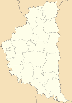
Community Map
Map Legend:
| The regional center, more than 200,000 people. | |
| from 20,000 to 50,000 | |
| from 10,000 to 20,000 people. | |
| from 5,000 to 10,000 people. | |
| from 2,000 to 5,000 | |
| from 1,000 to 2,000 |
Administrative-territorial structure
General information
The administrative center of the Ternopil region is the city of Ternopol .
The number of administrative units, councils and settlements of the region [1] :
- districts - 17;
- districts in cities - 0;
- settlements - 1057, including:
- rural - 1022;
- urban - 35, including:
- urban-type settlements - 17;
- 18 cities, including:
- cities of regional significance - 4; [12]
- cities of regional significance - 14;
- village councils - 580.
Local self-government in the region is carried out by the Ternopil Regional Council, the executive branch is the regional state administration. The head of the region is the chairman of the regional state administration appointed by the President of Ukraine .
Neighborhoods
In the Ternopil region 17 districts:
|
|
Cities
Cities of regional significance:
- Ternopil
- Berezhany [12]
- Kremenets [12]
- Chortkov
Cities of district significance:
|
|
| Settlements with a population of over 5 thousand as of January 1, 2015 [1] | ||||||||||||||||||||||||||||||||||||||||
|
Authorities
In the extraordinary elections to the Ternopil Regional Council that took place on March 15, 2009, the following political forces passed to the regional council [13] [14] :
- The All-Ukrainian Association "Freedom" - 34.69% of the vote (50 deputy mandates out of 120),
- " Unified Center " - 14.2% (20 mandates in the regional council),
- Party of Regions - 9.8% (14 mandates),
- Yulia Tymoshenko’s bloc - 8.1% (12 mandates, which all those on the BYuT list refused May 11, 2009 [15] ),
- Ukrainian People's Party - 7.99% (11 seats),
- " Our Ukraine - People’s Self-Defense " - 5.52% (8 mandates),
- Lytvyn’s People’s Bloc - 3.6% (5 mandates).
6.78% of those who took part in the vote voted against all.
The governor of the region (head of state administration) is Valentin Antonovich Khoptyan . Since the end of March 2009, the Ternopil Regional Council has been headed by the representative of the Freedom All-Russian Association, Alexei Kaida [16] .
The mayor is S. Nadal .
Economics
| N | indicator | units | value, 2014 year |
|---|---|---|---|
| one | Export of goods | million US dollars | 359.0 [17] |
| 2 | Ud.weight in the all-Ukrainian | % | 0.7 |
| 3 | Import of goods | million US dollars | 303.7 [17] |
| four | Ud.weight in the all-Ukrainian | % | 0.6 |
| five | Balance export - import | million US dollars | 55.3 [17] |
| 6 | Capital investment | million hryvnias | 2433.1 [18] |
| 7 | Average salary | UAH | 2527 [19] |
| eight | Average salary [20] | US dollars | 212.6 [21] |
According to the materials of the Committee of Statistics of Ukraine (Ukrainian) and the Main Department of Statistics in the Ternopil region (Ukrainian)
Agricultural Sector
The agricultural sector is the leading sector of the economy of the Ternopil region. Its share in the gross output of the region is over 60%. The agricultural sector of the Ternopil region produces 3% of all-Ukrainian agricultural products ; sugar and alcohol - more than 10%. Currently, there are 1,018 thousand hectares of agricultural land, including 834 thousand hectares of arable land - 0.82 hectares per inhabitant; 9307 tractors , 2547 combines (16 tractors per 1000 hectares of arable land, 7 combines per 1000 hectares of grain). 78.3 thousand people work, or 28% of all those employed in social production. After the reform of the agricultural sector, 578 agricultural enterprises were created, including private-rental enterprises - 297, business associations - 247, cooperatives - 14, state-owned - 8, other forms - 12, peasant farms - 721, serving cooperatives - 25.
In the Ternopil region, grain and sugar beet subcomplexes have the largest share. The grain product subcomplex combines 432 thousand hectares of crops of grain and leguminous crops, 15 grain receiving points, over 250 mills and grinders , almost 150 bakeries and workshops. The sugar beet sub-complex includes 9 sugar factories with a total production capacity of 35 thousand tons per day, as well as over 500 beet-growing farms with a total area of 78 thousand hectares. Since 1997, the farms of the region from the sale of sugar raw materials have suffered losses. Most sugar factories have reduced sugar production due to a lack of raw materials .
Industry
In the structure of industrial production in the Ternopil region, the largest share is held by the food industry, mechanical engineering, and light industry. In the structure of production of consumer goods, the share of food products is 71%. In total, 270 industrial enterprises operate in the region, 347 small industrial enterprises also function [4] .
The decisive role in the industry of the region is played by the city of Ternopol. Vatra OJSC, Orion and Saturn radio factories, and a car repair plant are located here. Light industry is represented by Teksterno OJSC , a sewing and haberdashery factory; food industry - sugar, two bakeries, two breweries, a dairy, a meat factory. The reinforced concrete plant, brick, asphalt concrete and porcelain factories stand out from the enterprises of the construction industry. There are also enterprises of woodworking (furniture factory) and chemical industry (pharmaceutical factory) [22] .
Social Issues
Since 2008, in Ternopol’s, it has been invariably fixed [23] at the same time the lowest wage level among all regions of Ukraine [24] and the highest officially registered unemployment rate [25] .
Culture
There are 1927 cultural and art institutions in the Ternopil region, of which 927 are club-type cultural institutions and 927 libraries, 52 schools of aesthetic education, 4 state museums, two theaters, a regional philharmonic society, 2 higher educational institutions of 1-3 degrees of accreditation, and a regional methodical center of folk creativity and the regional communal educational-methodical center [4] . On the territory of the Ternopil region is one of the most revered monasteries of the Ukrainian Orthodox Church - Pochaev Lavra .
Ecology
An analysis of the ecological state for 2001-2003 showed that the largest air pollutants in the region belong to the Gusyatinsky gas compressor station, the Ternopol linear gas pipeline management, sugar factories, and thermal stations. In industry, most pollutants are emitted into the air when fuel is burned in thermal units. The largest contribution to the gross emissions of pollutants into the air of the Ternopol region was made by the enterprises: the city of Ternopol - 0.902 thousand tons, the Gusyatinsky district - 1.344 thousand tons, the Kremenetsky district - 0.954 thousand tons, the Ternopol region –1.317 thousand tons ., Chortkovsky district - 1.211 thousand tons. The highest emission density per 1 sq. Km. km It was observed in the city of Ternopol - 15.203 tons. About 74% of the percent (27.139 thousand tons) of all emissions of pollutants in the region was emitted by road [26] .
The greatest use of water is carried out from the river basins of Seret, Strypa, Zolotaya Lipa, Goryn. Less water is taken from the river basins of Zbruch, Koropets, Nichlava, Ikva [27] .
According to the data of 2001-2003, the main pollutants of surface water sources were the objects of housing and communal services - Chortkovskaya VUVKG, Monastyrsky, Shumsky, Lanovetsky, Borschevsky, Zborovsky combines of communal enterprises, Kremenetsky housing and communal services, Berezhansky SE "Kommunalshchik", etc .; enterprises of the dairy and food industry - Vishnivetsky cheese factory OJSC, Monastyrysky milk factory OJSC, Berezhansky creamery OJSC, Agrofood OJSC, Zaleshchitsky cannery, healthcare facilities, education, etc. Not all settlements of Ternopolskaya are equipped with sewage treatment plants water, dilapidated many existing sewage treatment plants [27] .
More than a third of arable land is subjected to water erosion , moreover, in Berezhansky and Zborovsky districts, it is manifested on almost two-thirds of arable land, and in Zbarazhsky, Lanovetsky, Monastyrisky, Podvolochissky, Shumsky districts, more than half of the cultivated area lends itself to washout. As a result of the Chernobyl accident in the Ternopil region, 18.7 thousand ha of agricultural land remain partially contaminated with cesium-137 , of which 17824 ha (94.6%) are arable land, 709 ha (3.8%) are meadows and pastures, 316 ha (1.6%) - perennial plantations [28] .
Attractions
In the Ternopil region preserved monuments of history and culture:
- v. Vishnevets: the palace of the magnates of Vishnevetsky and the park of the XVIII century
- Gusyatin village : Onufrievskaya church of the second half of the 16th century, the Bernardine church and monastery of the 16th – 17th centuries, the town hall;
- Zalishchyky : a palace of the 18th century;
- with. Mezhgorye: the old Slavic cave church of the 10th-17th centuries with a sacrificial stone and the Ascension Church of the 17th century;
- Podgaytsy : church of the XV — XVII centuries, Assumption Church of the XVII century, synagogue of the XVII century;
- Pochaev - Pochaev Lavra ;
- p. Mikulintsy : a castle of the 16th century, a palace of the 18th-19th centuries, a church of the 18th century;
- with. Krivche : castle of the 17th century;
- with. Sapogov: a wooden church of the XVIII century;
- Skala-Podolskaya settlement : castle of the XV — XVI centuries, defensive tower of the XVI century, baroque palace, church and park of the XVIII century;
- Mr. Skalat - the castle in 1630 ;
- with. Skoriki: the wooden church of St. John the Evangelist of the 17th century;
- with.Yazlovets (formerly Yablonovka) of the Buchach region: the ruins of the castle of the XIV-XVIII centuries, the Nikolaev church of the XVII century, the Assumption Church with a bell tower 1589-1590, the palace of the middle of the XVII century [29] .
Notes
- ↑ 1 2 3 4 Государственный комитет статистики Украины. Сборник: Численность наличного населения Украины на 1 января 2015 года. Киев 2015. Ответственная за выпуск Тимошенко Г. М. (doc) (укр.)
- ↑ 1 2 Статистичний збірник «Регіони України» 2016. Частина І / За редакцією І. М. Жук. Відповідальний за випуск М. Б. Тімоніна. — К. : Державна служба статистики України , 2016. — С. 261. (укр.)
- ↑ Поділля. Тернопільщина (недоступная ссылка) . Дата обращения 20 марта 2009. Архивировано 15 июня 2013 года.
- ↑ 1 2 3 4 5 6 7 Тернопільська область — інформаційна картка
- ↑ 1 2 3 Загальний огляд економіки області
- ↑ Дороничев В. Б. Индустрии с листовидными бифасиальными наконечниками в среднем палеолите Восточной Европы и Кавказа
- ↑ Shkrdla P. Bohunice in the territories of Moravia and neighboring regions // Archeology, Ethnography and Anthropology of Eurasia. 3 (55) 2013
- ↑ На Украине найдены останки женщины, похороненной живьем
- ↑ Название изменено Указом Президиума Верховного совета СССР от 9 августа 1944 года
- ↑ Национальный состав Тернопольской области
- ↑ Портрет избирателя: религия
- ↑ 1 2 3 Верховная Рада Украины приняла ряд постановлений про отнесение некоторых населённых пунктов к категории городов областного значения (укр.)
- ↑ Суд запретил публиковать результаты тернопольских выборов
- ↑ Окончательные результаты выборов в Тернопольской области (список) Архивировано 23 марта 2009 года.
- ↑ БЮТ отказался от мандатов в Тернопольском облсовете
- ↑ Тернопольский облсовет возглавил человек Тягнибока
- ↑ 1 2 3 Географическая структура внешней торговли товарами области за 2014 год (укр.)
- ↑ Капитальные инвестиции по видам активов за январь — декабрь 2014 года (укр.)
- ↑ Среднемесячная заработная плата штатных работников по городам и районам Тернопольской области за 2014 год (укр.) (недоступная ссылка) . Дата обращения 30 мая 2015. Архивировано 4 марта 2016 года.
- ↑ Официальный курс гривны НБУ (средний за период) (укр.)
- ↑ Курс 11,8867 за 2014 г.
- ↑ Подільський соціально-економічний район (недоступная ссылка) . Дата обращения 20 марта 2009. Архивировано 22 марта 2009 года.
- ↑ Средняя заработная плата (Тернопольская обл.) . index.minfin.com.ua. Date of treatment March 13, 2019.
- ↑ Информация Торгпредства РФ в Республике Украина за период 01-12 февраля 2008 (недоступная ссылка)
- ↑ Информация Торгпредства РФ в Республике Украина за период 14-26 февраля 2008 (недоступная ссылка)
- ↑ Атмосферне повітря (недоступная ссылка) . Дата обращения 19 марта 2009. Архивировано 13 мая 2013 года.
- ↑ 1 2 Водні ресурси (недоступная ссылка) . Дата обращения 19 марта 2009. Архивировано 13 мая 2013 года.
- ↑ Забруднення грунтів (недоступная ссылка) . Дата обращения 19 марта 2009. Архивировано 13 мая 2013 года.
- ↑ Тернопольская область в Энциклопедии туриста