Gorkovskoye Reservoir - a reservoir on the Volga River [1] , formed by the dam of the Nizhny Novgorod hydroelectric power station . Due to its size, as well as due to storms with a wave height of more than 2 meters, the Gorky Sea has the common name. Included in the Volga cascade of reservoirs .
| Gorky reservoir | |
|---|---|
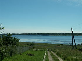 View of the reservoir from the village of Porozovo | |
| Morphometry | |
| Height above sea level | 84 m |
| Dimensions | 440 [1] × <14 [1] km |
| Square | 1590 [1] km² |
| Volume | 8.71 [1] km³ |
| Deepest | 22 m |
| Average depth | 3.65 m |
| Specifications | |
| Year of filling | 1955-1957 [1] |
| Pool | |
| Flowing watercourses | Mera , Unzha , Nyomda |
| Flowing watercourse | Volga |
| Location | |
| A country |
|
| Subjects of the Russian Federation | Yaroslavl region , Kostroma region , Ivanovo region , Nizhny Novgorod region |
| HWR code | |


Area - 1590 km², volume - 8.71 km³, length - 440 km, width - up to 14 km [1] , average depth - 3.65 m, maximum depth - 22 m. The right side of the reservoir is navigable. Altitude - 84 m.
Located in the Yaroslavl , Kostroma , Ivanovo and Nizhny Novgorod regions [1] . In the upper section, the water flooded only the floodplain and the first terrace . A vast lowland called the Kostroma Gulf is flooded in the confluence of the Kostroma River . Below the city of Yuryevets, on the site of the ancient Puchezh-Katunsky crater , the expanded lake-shaped part of the reservoir begins, reaching 14 km in some places.
The filling of the reservoir began on August 24, 1955, after the closure of the Volga channel in the area of the dam under construction, and continued until 1957. The water drop in the Gorky (Nizhny Novgorod) hydroelectric station amounted to 17 meters. The backwater of the reservoir forms a deep-water navigable route to Yaroslavl and Rybinsk , the passage of vessels downstream is provided by two-chamber locks of the Gorodets Hydroelectric Station [3] .
High and picturesque shores - in the area of the city of Plyos . Weekly flow regulation is carried out; water level fluctuations up to 2 m. Created in the interests of energy , shipping . Widely used for recreation and fishing . On the banks of the city are: Rybinsk , Tutaev , Yaroslavl , Kostroma , Plyos , Navoloki , Kineshma , Zavolzhsk , Yuryevets , Puchezh , Chkalovsk , Zavolzhye , Gorodets .
Due to the filling of the reservoir, the Sokolsky district of the Ivanovo region was cut off from the regional center and was later annexed to the Nizhny Novgorod region.
Topographic maps
Notes
- ↑ 1 2 3 4 5 6 7 8 Gorky reservoir // Great Soviet Encyclopedia : [in 30 vol.] / Ch. ed. A.M. Prokhorov . - 3rd ed. - M .: Soviet Encyclopedia, 1969-1978.
- ↑ Surface Water Resources of the USSR: Hydrological Understanding. T. 10. Upper Volga region / ed. V.P. Shaban. - L .: Gidrometeoizdat, 1966 .-- 528 p.
- ↑ Pipe L. L. Geography of the Gorky region. - Gorky: Volga-Vyatka Prince. Publishing House, 1978.- 176 p.